La-Ronciere-Insel
| La-Ronciere-Insel | ||
|---|---|---|
 | ||
| Gewässer | Arktischer Ozean | |
| Inselgruppe | Franz-Josef-Land | |
| Geographische Lage | 81° 0′ N, 60° 52′ O8160.866666666667431Koordinaten: 81° 0′ N, 60° 52′ O | |
| ||
| Länge | 29 km | |
| Breite | 19 km | |
| Fläche | 478 km² | |
| Höchste Erhebung | 431 m | |
| Einwohner | unbewohnt | |
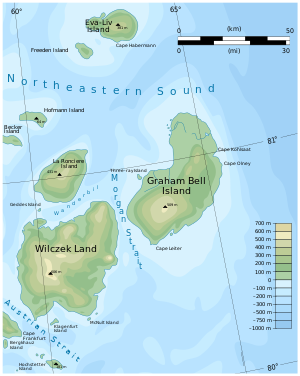 | ||


Die La-Ronciere-Insel (russisch Остров Ла-Ронсьер, Ostrow La-Ronsjer) ist eine unbewohnte Insel des zu Russland gehörenden arktischen Franz-Josef-Lands.
Sie liegt im Osten des Archipels und ist vom südlich gelegenen Wilczek-Land durch die 10 km breite Vanderbilt-Straße getrennt. Die Arthur-Insel ist 478 km² groß[1] und bis auf die Küstenregion um Kap Hitt im Nordosten sowie das Westkap Mys Rogaty von einer bis zu 431 m hohen Eiskappe bedeckt.
Die La-Ronciere-Insel wurde von der Österreich-Ungarischen Nordpolarexpedition (1872–1874) entdeckt und für eine Halbinsel von Wilczek-Land gehalten. Julius Payer benannte sie nach Camille de La Roncière-Le Noury (1816–1881), dem Präsidenten der französischen Société de Géographie. Ihren Inselcharakter erkannte erst Evelyn Briggs Baldwin, der während der Walter-Wellman-Expedition (1898–1899) mit dem Hundeschlitten durch die Vanderbilt-Straße fuhr.[2] Wellmans Benennung der Insel nach William Collins Whitney, einem Finanzier seiner Expedition, hatte keinen Bestand.[3]
Einzelnachweise
- ↑ Andreas Umbreit: LaRonciere Insel – Franz-Joseph-Land (Memento vom 29. Januar 2021 im Internet Archive)
- ↑ Peter J. Capelotti: E. B. Baldwin and the American–Norwegian discovery and exploration of Graham Bell Island, 1899. In: Polar Research. Band 25, Nr. 2, 2006, S. 155–171. doi:10.3402/polar.v25i2.6245
- ↑ Peter J. Capelotti: The Greatest Show in the Arctic: The American Exploration of Franz Josef Land, 1898–1905. University of Oklahoma Press, Norman (Oklahoma) 2016, ISBN 978-0-8061-5222-6, S. 185 (englisch, eingeschränkte Vorschau in der Google-Buchsuche).
Weblinks
- Topografische Karte der Insel im Maßstab 1:200.000
Inseln des Franz-Josef-Landes
Aagaard-Insel | Adelaide-Insel | Alexandraland | Alger-Insel | Apollonow-Insel | Arthur-Insel | Becker-Insel | Bell-Insel | Berghaus-Insel | Bliss-Insel | Borisjak-Insel | Brady-Insel | Brosch-Insel | Brice-Insel | Bromwich-Insel | Brown-Inseln | Bruce-Insel | Champ-Insel | Coburg-Insel | David-Insel | Davis-Insel | Derewjanny-Insel | Dicks-Insel | Eaton-Insel | Etheridge-Inseln | Elizabeth-Insel | Eva-Liv-Insel | Freeden-Insel | Geddes-Insel | Gorbunow-Insel | Graham-Bell-Insel | Greely-Insel | Hall-Insel | Harley-Insel | Hayes-Insel | Hochstetter-Inseln | Hoffmann-Insel | Hohenlohe-Insel | Hooker-Insel | Houen-Insel | Iwanow-Insel | Jackson-Insel | Jefferson-Insel | Kane-Insel | Karl-Alexander-Insel | Klagenfurt-Insel | Kling-Insel | Knospe-Insel | Koettlitz-Insel | Koldewey-Insel | Komsomol-Inseln | Kupolok-Insel | Kutschin-Inseln | Kuhn-Insel | La-Ronciere-Insel | Lamont-Insel | Leigh-Smith-Insel | Lewanewski-Insel | Luigi-Insel | Lütke-Insel | Mabel-Insel | MacGee-Inseln | May-Insel | Maly-Insel | Marley-Insel | Mathilda-Insel | McClintock-Insel | McNulty-Insel | Nansen-Insel | Newcomb-Insel | Newton-Insel | Nitsch-Insel | Northbrook-Insel | Nowy-Insel | Ommanney-Insel | Payer-Insel | Perlmutt-Insel | Pontremoli-Inseln | Prinz-Georg-Land | Querini-Insel | Rainer-Insel | Robinson-Insel | Royal-Society-Insel | Rudolf-Insel | Salisbury-Insel | Salm-Insel | Schönau-Insel | Scott-Keltie-Insel | Solowjow-Insel | Stoliczka-Insel | Sub-Insel | Tillo-Insel | Torup-Insel | Tom-Insel | Trjochlutschewoi-Insel | Tschitschagow-Inseln | Udatschny-Insel | Ugolnoi-Kopi-Insel | Weyprecht-Insel | Windward-Insel | Wiener-Neustadt-Insel | Wilczek-Insel | Wilczek-Land | Ziegler-Insel


