Liste der Einträge im National Register of Historic Places im Franklin County (Massachusetts)

Die Liste der Einträge im National Register of Historic Places im Franklin County in Massachusetts führt alle Bauwerke, National Historic Landmarks und historischen Stätten im Franklin County auf, die in das National Register of Historic Places aufgenommen wurden.[1]
Legende
| NRHP | Historic Place |
|---|---|
| NHL | Historic Landmark |
| NHLD | Historic Landmark District |
| HD | Historic District |
Aktuelle Einträge
| [2] | Name[3] | Bild | Eintragsdatum | Lage | Ort | Beschreibung |
|---|---|---|---|---|---|---|
| 1 | Simeon Alexander, Jr., House |  | 28. Mai 1991 ID-Nr. 91000598 | Millers Falls Rd. 42° 38′ 19″ N, 72° 27′ 56,2″ W42.6386-72.4656 | Northfield | |
| 2 | Alvah Stone Mill | 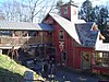 | 30. Juni 1997 ID-Nr. 97000562 | 440 Greenfield Rd. 42° 32′ 16″ N, 72° 32′ 20″ W42.537778-72.538889 | Montague | |
| 3 | Ashfield Plain Historic District | 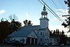 | 20. Sep. 1991 ID-Nr. 91001373 | 42° 31′ 37″ N, 72° 47′ 17″ W42.526944-72.788056 | Ashfield | |
| 4 | Bardwell’s Ferry Bridge | 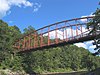 weitere Bilder | 10. Feb. 2000 ID-Nr. 00000076 | Bardwell’s Ferry Rd. 42° 33′ 20″ N, 72° 40′ 41″ W42.555556-72.678056 | Conway | |
| 5 | Benson’s New Block and the Mohawk Chambers |  | 11. März 2014 ID-Nr. 14000046 | 42° 35′ 16,8″ N, 72° 36′ 14,4″ W42.588-72.604 | Greenfield | |
| 6 | Bernardston Congregational Unitarian Church | 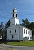 | 18. März 1993 ID-Nr. 93000128 | Church und Depot Sts. 42° 40′ 14″ N, 72° 33′ 0″ W42.670556-72.55 | Bernardston | |
| 7 | Bissell Bridge |  | 26. Feb. 2004 ID-Nr. 04000083 | Heath Rd. 42° 37′ 57″ N, 72° 52′ 10″ W42.6325-72.869444 | Charlemont | |
| 8 | Burkeville Covered Bridge |  | 9. Sep. 1988 ID-Nr. 88001456 | Main Poland Rd. 42° 29′ 1″ N, 72° 42′ 44″ W42.483611-72.712222 | Conway | |
| 9 | Charlemont Village Historic District |  | 10. Feb. 1988 ID-Nr. 87001880 | MA 2 (Main St.) zwischen South und Harmont Sts. 42° 37′ 40″ N, 72° 52′ 27″ W42.627778-72.874167 | Charlemont | |
| 10 | Colrain Center Historic District |  | 15. Nov. 2006 ID-Nr. 06001057 | 42° 40′ 24″ N, 72° 41′ 52″ W42.673333-72.697778 | Colrain | |
| 11 | Conway Center Historic District |  | 10. Sep. 1999 ID-Nr. 99001043 | 42° 30′ 31″ N, 72° 41′ 50″ W42.508611-72.697222 | Conway | |
| 12 | Dedic Site |  | 16. Juli 1980 ID-Nr. 80000504 | Die genaue Lage wird nicht veröffentlicht. | Deerfield | Archäologische Ausgrabung |
| 13 | Deerfield Valley Agricultural Society Fairgrounds |  | 11. Mai 2011 ID-Nr. 11000267 | Park St. 42° 37′ 51″ N, 72° 52′ 3″ W42.630833-72.8675 | Charlemont | |
| 14 | East Charlemont District School | 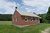 | 7. März 2017 ID-Nr. 100000721 | 1811 MA 2 | Charlemont | |
| 15 | East Hawley Center Historic District |  | 24. Juli 1992 ID-Nr. 92000951 | 42° 33′ 48″ N, 72° 52′ 43″ W42.563333-72.878611 | Hawley | |
| 16 | East Leverett Historic District |  | 29. Jan. 2014 ID-Nr. 13001131 | 42° 26′ 17,8″ N, 72° 28′ 57,6″ W42.438281-72.48268 | Leverett | |
| 17 | East Main-High Street Historic District |  | 16. März 1989 ID-Nr. 88002011 | 42° 35′ 20″ N, 72° 35′ 49″ W42.588889-72.596944 | Greenfield | |
| 18 | Franklin County Fairgrounds |  | 15. Juni 2011 ID-Nr. 11000359 | 89 Wisdom Way 42° 34′ 44″ N, 72° 36′ 42″ W42.578889-72.611667 | Greenfield | |
| 19 | Garden Theater Block |  | 1. Sep. 1983 ID-Nr. 83000591 | 353-367 Main St. 42° 35′ 15″ N, 72° 36′ 1″ W42.5875-72.600278 | Greenfield | |
| 20 | Gill Center Historic District | 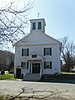 | 5. Nov. 2018 ID-Nr. 100003068 | Center, Main, Cross, Boyle, River & Lyons Hill Rds. 42° 38′ 27″ N, 72° 30′ 9,3″ W42.640823-72.5025743 | Gill | |
| 21 | Maj. Joseph Griswold House |  | 23. Feb. 1972 ID-Nr. 72000130 | Upper St. 42° 35′ 25,7″ N, 72° 47′ 38,7″ W42.590468-72.794087 | Buckland | |
| 22 | Heath Center Historic District |  | 25. Okt. 2007 ID-Nr. 07001103 | 42° 40′ 25″ N, 72° 49′ 19″ W42.673603-72.821944 | Heath | Eine Erweiterung der Distriktgrenzen wurde am 24. August 2017 eingetragen. |
| 23 | Hill Cemetery and Parson Hubbard House Historic District |  | 23. Aug. 2006 ID-Nr. 06000716 | Old Village Rd. 42° 35′ 54″ N, 72° 41′ 16″ W42.598333-72.687778 | Shelburne | |
| 24 | King Philip’s Hill |  | 16. Dez. 1981 ID-Nr. 81000106 | Old Bernardston Road 42° 41′ 2″ N, 72° 28′ 35″ W42.683889-72.476389 | Northfield | |
| 25 | Leavitt-Hovey House |  | 22. Dez. 1983 ID-Nr. 83003977 | 402 Main St. 42° 35′ 17″ N, 72° 35′ 58″ W42.588056-72.599444 | Greenfield | |
| 26 | Leverett Center Historic District | 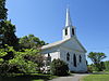 | 5. Dez. 2008 ID-Nr. 08001127 | 42° 27′ 4,6″ N, 72° 30′ 6,2″ W42.451286-72.501728 | Leverett | |
| 27 | Long Plain Cemetery | 29. Juni 2020 ID-Nr. 100005304 | 19 Deport Rd. 42° 27′ 2,9″ N, 72° 31′ 39,2″ W42.4508003-72.5275501 | Leverett | ||
| 28 | Main Street Historic District |  | 13. Okt. 1988 ID-Nr. 88001908 | 42° 35′ 13″ N, 72° 36′ 5″ W42.586944-72.601389 | Greenfield | |
| 29 | Millers Falls Village Historic District |  weitere Bilder | 22. Nov. 2021 ID-Nr. 100007171 | 42° 34′ 45″ N, 72° 29′ 36″ W42.579167-72.493333 | Montague | |
| 30 | Montague Center Historic District |  | 16. Nov. 2001 ID-Nr. 01001236 | 42° 32′ 6″ N, 72° 32′ 5″ W42.535-72.534722 | Montague | |
| 31 | Moore’s Corner Historic District |  | 19. Mai 2014 ID-Nr. 14000215 | 42° 29′ 40,2″ N, 72° 28′ 5,9″ W42.4945-72.4683 | Leverett | |
| 32 | New Salem Common Historic District | 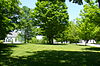 weitere Bilder | 12. Apr. 1978 ID-Nr. 78000443 | S. Main St. 42° 29′ 55″ N, 72° 19′ 54″ W42.498611-72.331667 | New Salem | |
| 33 | Newton Street School |  | 27. Okt. 1988 ID-Nr. 88001907 | Shelburne Rd. 42° 35′ 8″ N, 72° 36′ 52″ W42.585556-72.614444 | Greenfield | |
| 34 | North Cemetery | 1. Juli 2020 ID-Nr. 100005276 | 42° 28′ 3″ N, 72° 30′ 1,6″ W42.4674976-72.5004399 | Leverett | ||
| 35 | North Leverett Historic District | 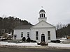 | 13. Juni 2014 ID-Nr. 14000326 | 42° 30′ 28,4″ N, 72° 29′ 31,2″ W42.5079-72.492 | Leverett | |
| 36 | Northfield Center Cemetery |  | 13. Nov. 2004 ID-Nr. 04001220 | Parker Ave. 42° 41′ 41″ N, 72° 27′ 40″ W42.694722-72.461111 | Northfield | |
| 37 | Northfield Main Street Historic District |  | 8. Juli 1982 ID-Nr. 82004965 | 42° 41′ 50″ N, 72° 27′ 16″ W42.697222-72.454444 | Northfield | |
| 38 | Odd Fellows’ Hall |  | 10. Mai 1979 ID-Nr. 79000345 | 1-5 State St. 42° 36′ 14″ N, 72° 44′ 23″ W42.603889-72.739722 | Buckland | |
| 39 | Old Deerfield Historic District |  weitere Bilder | 15. Okt. 1966 ID-Nr. 66000774 | 42° 33′ 4″ N, 72° 36′ 30″ W42.551111-72.608333 | Deerfield | |
| 40 | Orange Center Historic District |  | 27. Apr. 1989 ID-Nr. 89000057 | 42° 35′ 24″ N, 72° 18′ 39″ W42.59-72.310833 | Orange | |
| 41 | Pine Street School |  | 13. März 2002 ID-Nr. 02000156 | 13 Pine St. 42° 42′ 32″ N, 72° 26′ 50″ W42.708889-72.447222 | Northfield | |
| 42 | Powers Institute Historic District |  | 18. März 1994 ID-Nr. 93000127 | 42° 40′ 16″ N, 72° 33′ 12″ W42.671111-72.553333 | Bernardston | |
| 43 | Riverside Archeological District | 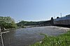 | 9. Juli 1975 ID-Nr. 75000256 | Die genaue Lage wird nicht veröffentlicht. | Greenfield und Gill | Archäologische Ausgrabung |
| 44 | Riverside Village Historic District |  | 18. Sep. 2017 ID-Nr. 100001617 | 42° 36′ 37,3″ N, 72° 32′ 55,4″ W42.6103699-72.5487107 | Gill | |
| 45 | Shelburne Falls Historic District |  | 28. Jan. 1988 ID-Nr. 87002548 | 42° 36′ 11″ N, 72° 44′ 25″ W42.603056-72.740278 | Buckland und Shelburne | |
| 46 | Shelburne Free Public Library | 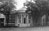 | 18. Juli 2016 ID-Nr. 16000453 | 233 Shelburne Center Rd. 42° 35′ 20,1″ N, 72° 41′ 19,6″ W42.588928-72.688787 | Shelburne | |
| 47 | Arthur A. Smith Covered Bridge |  | 3. Feb. 1983 ID-Nr. 83000592 | Lyonsville Rd. 42° 40′ 12″ N, 72° 43′ 9″ W42.67-72.719167 | Colrain | |
| 48 | South School | 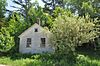 | 26. Dez. 2007 ID-Nr. 07001312 | 6 Schoolhouse Rd. 42° 25′ 11″ N, 72° 26′ 0″ W42.419722-72.433333 | Shutesbury | |
| 49 | Sunderland Center Historic District |  | 15. März 2002 ID-Nr. 02000157 | 42° 27′ 59″ N, 72° 34′ 46,4″ W42.466397-72.579567 | Sunderland | |
| 50 | Old Tavern Farm |  | 10. März 2005 ID-Nr. 05000120 | 817 Colrain Rd. 42° 37′ 20″ N, 72° 38′ 9″ W42.622222-72.635833 | Greenfield | |
| 51 | Turners Falls Historic District |  | 2. Mai 1982 ID-Nr. 82004966 | 42° 36′ 30″ N, 72° 33′ 23″ W42.608333-72.556389 | Montague | |
| 52 | US Post Office-Greenfield Main |  | 20. Dez. 1985 ID-Nr. 85003224 | 442 Main St. 42° 35′ 15″ N, 72° 35′ 53″ W42.5875-72.598056 | Greenfield | |
| 53 | Weldon Hotel |  | 6. Aug. 1980 ID-Nr. 80000503 | 54 High St. 42° 35′ 26″ N, 72° 35′ 44″ W42.590556-72.595556 | Greenfield | |
| 54 | Wendell Town Common Historic District |  | 21. Mai 1992 ID-Nr. 92000580 | 42° 32′ 55″ N, 72° 23′ 51″ W42.548611-72.3975 | Wendell | |
| 55 | West Whately Historic District |  | 10. Okt. 2003 ID-Nr. 03001018 | 42° 26′ 17,9″ N, 72° 40′ 55,2″ W42.4383-72.682 | Whately | |
| 56 | Whately Center Historic District |  | 11. Sep. 2003 ID-Nr. 03000920 | 42° 26′ 18″ N, 72° 38′ 9″ W42.438333-72.635833 | Whately | |
| 57 | Whitaker-Clary House |  | 18. Juni 1975 ID-Nr. 75000257 | Elm St. 42° 32′ 26″ N, 72° 18′ 58″ W42.540556-72.316111 | New Salem | Sitz der Swift River Historical Society |
| 58 | The Wilder Homestead |  | 24. Jan. 2011 ID-Nr. 10001178 | Ashfield Rd. 42° 35′ 59″ N, 72° 46′ 44″ W42.599722-72.778889 | Buckland | |
| 59 | Robert Strong Woodward House and Studio |  | 11. Jan. 2018 ID-Nr. 100001961 | 43 Upper St. 42° 35′ 15,9″ N, 72° 47′ 50,4″ W42.5877457-72.797328 | Buckland |
Siehe auch
- Liste der National Historic Landmarks in Massachusetts
- National Register of Historic Places in Massachusetts
Weblinks
Commons: National Register of Historic Places in Franklin County, Massachusetts – Sammlung von Bildern, Videos und Audiodateien
Einzelnachweise
- ↑ Auszug aus dem National Register of Historic Places - Franklin County Abgerufen am 20. November 2015
- ↑ Die Nummerierung in dieser Listenspalte ist an der vom National Park Service vorgelegten Reihenfolge der Einträge orientiert; die Farben unterscheiden verschiedene Schutzgebietstypen des Nationalparksystems mit landesweiter Bedeutung (z. B. National Historic Landmarks) von den sonstigen Einträgen im National Register of Historic Places.
- ↑ National Register Information System. In: National Register of Historic Places. National Park Service, abgerufen am 13. März 2009 (englisch).
- Karte mit allen Koordinaten:
- OSM
- WikiMap
V
Einträge im National Register of Historic Places in Massachusetts| Countys | Barnstable • Berkshire • Bristol • Dukes • Essex • Franklin • Hampden • Hampshire • Middlesex • Nantucket • Norfolk • Plymouth • Suffolk • Worcester (Nord | Süd) | ||||||||||||||||
| Städte |
|


