Liste der Einträge im National Register of Historic Places im Grant County (Wisconsin)

Die Liste der Registered Historic Places im Grant County in Wisconsin führt alle 35 Bauwerke und historischen Stätten im Grant County auf, die in das National Register of Historic Places aufgenommen wurden.[1]
Legende
| NRHP | Historic Place |
|---|---|
| HD | Historic District |
Aktuelle Einträge
| Lfd. Nr. | Name im NRHP | Bild | Jahr der Eintragung | Adresse / Lage | Ort | NRHP-ID |
|---|---|---|---|---|---|---|
| 1 | Agriculture and Manual Arts Building/Platteville State Normal School | 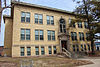 | 1985 | University of Wisconsin, Platteville 42° 44′ 3″ N, 90° 29′ 10″ W42.734166666667-90.486111111111 | Platteville | 85000578 |
| 2 | L. J. Arthur House |  | 1985 | 210 North Jefferson Street 42° 50′ 57″ N, 90° 42′ 39″ W42.849166666667-90.710833333333 | Lancaster | 85001951 |
| 3 | James Ballantine House |  | 1976 | 720 North 4th Street 42° 53′ 16″ N, 90° 55′ 34″ W42.887777777778-90.926111111111 | Bloomington | 76000062 |
| 4 | Bass Site (47Gt25) | 1982 | Lancaster | 82000669 | ||
| 5 | Bayley Avenue Historic District |  | 2007 | 100-400 Bayley Avenue, 400 Block South Court Street, 150, 210, 270 Rountree Avenue und 65 Mitchell Avenue 42° 43′ 52″ N, 90° 28′ 46″ W42.731111111111-90.479444444444 | Platteville | 07000708 |
| 6 | Beebe House | 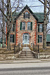 | 1979 | 390 West Adams Street 42° 44′ 19″ N, 90° 28′ 49″ W42.738611111111-90.480277777778 | Platteville | 79000078 |
| 7 | Bode-Wad-Mi Rockshelter | 1995 | Castle Rock | 95000760 | ||
| 8 | Boscobel Grand Army of the Republic Hall | 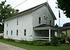 | 2007 | 102 Mary Street 43° 7′ 55″ N, 90° 42′ 23″ W43.131944444444-90.706388888889 | Boscobel | 07001329 |
| 9 | Boscobel High School |  | 1986 | 207 Buchanan Street 43° 7′ 59″ N, 90° 42′ 11″ W43.133055555556-90.703055555556 | Boscobel | 86003518 |
| 10 | Central House Hotel |  | 1996 | 1005 Wisconsin Avenue 43° 8′ 4″ N, 90° 42′ 20″ W43.134444444444-90.705555555556 | Boscobel | 96001361 |
| 11 | Courthouse Square Historic District |  | 2006 | Abgegrenzt durch Cherry Street, Jefferson Street, Madison Street und Maple Street 42° 50′ 51″ N, 90° 42′ 36″ W42.8475-90.71 | Lancaster | 06000233 |
| 12 | Denniston House |  | 1975 | 117 East Front Street 42° 42′ 45″ N, 90° 59′ 25″ W42.7125-90.990277777778 | Cassville | 75000213 |
| 13 | Division Street Historic District |  | 2007 | 200-300 Block Division Street, 145, 170, 175, 190, 195 und 220 South Chestnut Street 42° 43′ 57″ N, 90° 28′ 54″ W42.7325-90.481666666667 | Platteville | 07000709 |
| 14 | Eagle Valley Mound District | 2001 | Glen Haven | 01000736 | ||
| 15 | Fred Edwards Site | 1982 | Burton | 82005118 | ||
| 16 | Jonathan H. Evans House |  | 1982 | 440 West Adams Street 42° 44′ 20″ N, 90° 28′ 53″ W42.738888888889-90.481388888889 | Platteville | 82000670 |
| 17 | First Congregational Church |  | 1985 | 80 Market Street 42° 44′ 9″ N, 90° 28′ 42″ W42.735833333333-90.478333333333 | Platteville | 85001359 |
| 18 | Grant County Courthouse | 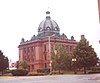 | 1978 | 126 West Main Street 42° 50′ 51″ N, 90° 42′ 36″ W42.8475-90.71 | Lancaster | 78000096 |
| 19 | Hazel Green Town Hall |  | 1989 | 2130 North Main Street 42° 32′ 0″ N, 90° 26′ 5″ W42.533333333333-90.434722222222 | Hazel Green | 88003231 |
| 20 | Hog Hollow Site | 1996 | Potosi | 96000496 | ||
| 21 | Patrick and Margaret Kinney House |  | 2008 | 424 North Fillmore Street 42° 51′ 6″ N, 90° 43′ 10″ W42.851666666667-90.719444444444 | Lancaster | 08000160 |
| 22 | Lancaster Municipal Building |  | 1983 | 206 South Madison Street 42° 50′ 51″ N, 90° 42′ 33″ W42.8475-90.709166666667 | Lancaster | 83003397 |
| 23 | Lancaster Post Office |  | 2000 | 236 West Maple Street 42° 50′ 52″ N, 90° 42′ 43″ W42.847777777778-90.711944444444 | Lancaster | 00001245 |
| 24 | Main Street Commercial Historic District |  | 1990 | Umgrenzt von Chestnut Street, Furnace Street, Bonson Street, Mineral Street, OakStreet und Pine Street 42° 44′ 4″ N, 90° 28′ 42″ W42.734444444444-90.478333333333 | Platteville | 90000377 |
| 25 | Mitchell-Rountree House | 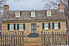 | 1972 | Jewett Street Ecke Lancaster Street 42° 44′ 29″ N, 90° 28′ 57″ W42.741388888889-90.4825 | Platteville | 72000052 |
| 26 | Dwight T. Parker Public Library | 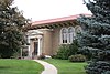 | 1983 | 925 Lincoln Avenue 42° 59′ 0″ N, 90° 39′ 18″ W42.983333333333-90.655 | Fennimore | 83003398 |
| 27 | Potosi Badger Huts Site |  | 1996 | 8 km südwestlich der Kreuzung der WI 133 mit der WI U 42° 41′ 10″ N, 90° 42′ 45″ W42.686111111111-90.7125 | Potosi | 96001532 |
| 28 | Potosi Brewery | 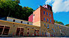 | 1980 | Main Street 42° 40′ 37″ N, 90° 43′ 32″ W42.676944444444-90.725555555556 | Potosi | 80000138 |
| 29 | Rountree Hall |  | 1974 | 30 North Elm Street 42° 44′ 7″ N, 90° 28′ 53″ W42.735277777778-90.481388888889 | Platteville | 74000091 |
| 30 | J. H. Rountree Mansion | 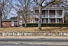 | 1986 | 150 Rountree Avenue 42° 43′ 56″ N, 90° 28′ 41″ W42.732222222222-90.478055555556 | Platteville | 86001307 |
| 31 | St. John Mine | 1979 | WI 133 42° 41′ 10″ N, 90° 42′ 56″ W42.686111111111-90.715555555556 | Potosi | 79000079 | |
| 32 | Stonefield |  | 1970 | 4 km nordwestlich von Cassville an der County Road VV 42° 44′ 3″ N, 91° 1′ 18″ W42.734166666667-91.021666666667 | Cassville | 70000034 |
| 33 | West Main Street Historic District |  | 2007 | Umgrenzt von Nort Elm Street, South Elm Street, West Pine Street, North Hickory Street, South Hickory Street und West Mineral Street 42° 44′ 3″ N, 90° 28′ 43″ W42.734166666667-90.478611111111 | Platteville | 07000710 |
| 34 | Wyalusing State Park Mounds Archeological District | 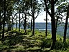 | 1999 | 13342 County Highway C 42° 58′ 52″ N, 91° 6′ 42″ W42.981111111111-91.111666666667 | Bagley | 99001175 |
| 35 | John Young House |  | 1994 | 323 South Wisconsin Avenue 43° 10′ 57″ N, 90° 26′ 35″ W43.1825-90.443055555556 | Muscoda | 94001157 |
Siehe auch
- Liste der National Historic Landmarks in Wisconsin
- National Register of Historic Places in Wisconsin
Einzelnachweise
- ↑ Auszug aus dem National Register of Historic Places - Grant County Abgerufen am 15. Juli 2012

Einträge im National Register of Historic Places in Wisconsin
National Register of Historic Places in Wisconsin
Adams | Ashland | Barron | Bayfield | Brown | Buffalo | Burnett | Calumet | Chippewa | Clark | Columbia | Crawford | Dane | Dodge | Door | Douglas | Dunn | Eau Claire | Florence | Fond du Lac | Forest | Grant | Green | Green Lake | Iowa | Iron | Jackson | Jefferson | Juneau | Kenosha | Kewaunee | La Crosse | Lafayette | Langlade | Lincoln | Manitowoc | Marathon | Marinette | Marquette | Menominee | Milwaukee | Monroe | Oconto | Oneida | Outagamie | Ozaukee | Pepin | Pierce | Polk | Portage | Price | Racine | Richland | Rock | Rusk | Sauk | Sawyer | Shawano | Sheboygan | St. Croix | Taylor | Trempealeau | Vernon | Vilas | Walworth | Washburn | Washington | Waukesha | Waupaca | Waushara | Winnebago | Wood


