Shelton (Connecticut)
| Shelton | |||
|---|---|---|---|
 Plumb Memorial Library | |||
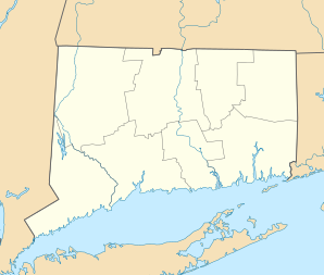
| Lage in Connecticut | |||
| |||
| Basisdaten | |||
| Gründung: | 1789 | ||
| Staat: | Vereinigte Staaten | ||
| Bundesstaat: | Connecticut | ||
| County: | Fairfield County | ||
| Koordinaten: | 41° 18′ N, 73° 8′ W41.304166666667-73.13805555555619Koordinaten: 41° 18′ N, 73° 8′ W | ||
| Zeitzone: | Eastern (UTC−5/−4) | ||
| Einwohner: | 40.869 (Stand: 2020) | ||
| Haushalte: | 16.516 (Stand: 2020) | ||
| Fläche: | 82,6 km² (ca. 32 mi²) davon 79,2 km² (ca. 31 mi²) Land | ||
| Bevölkerungsdichte: | 516 Einwohner je km² | ||
| Höhe: | 19 m | ||
| Postleitzahl: | 06484 | ||
| Vorwahl: | +1 203 | ||
| FIPS: | 09-68100 | ||
| GNIS-ID: | 0210800 | ||
| Website: | cityofshelton.org | ||
| Bürgermeister: | Mark A. Lauretti | ||

Shelton ist eine Stadt im Fairfield County im US-amerikanischen Bundesstaat Connecticut mit 40.869 Einwohnern (US-Census 2020).[1]
Die geografischen Koordinaten sind: 41,30° Nord, 73,14° West. Das Stadtgebiet hat eine Größe von 82,7 km².
Sehenswürdigkeiten
- Indian Well State Park: Der Park liegt am Westufer des Housatonic River und am Lake Housatonic (Stausee mit Strand und Bootsanlegeplatz).
National Register of Historic Places
- Plumb Memorial Library
Persönlichkeiten
- Helen Barnes (1895–1925), Schauspielerin
- Peter Leo Gerety (1912–2016), Erzbischof von Newark
- Ernest Rossi (1933–2020), Psychoanalytiker und -therapeut
Weblinks
Commons: Shelton (Connecticut) – Sammlung von Bildern, Videos und Audiodateien
- City of Shelton Offizielle Website
- City-Data.com Statistische Daten über Shelton
Einzelnachweise
- ↑ Explore Census Data. Abgerufen am 1. Juni 2022.
County Seat: Bridgeport
| Cities | Bridgeport • Danbury • Norwalk • Shelton • Stamford | |
| Towns | Bethel • Brookfield • Darien • Easton • Fairfield • Greenwich • Monroe • New Canaan • New Fairfield • Newtown • Redding • Ridgefield • Sherman • Stratford • Trumbull • Weston • Westport • Wilton | |
| CDPs | Ball Pond • Bethel • Bigelow Corners • Bogus Hill • Botsford • Branchville • Brookfield Center • Byram • Candlewood Isle • Candlewood Knolls • Candlewood Lake Club • ‡ Candlewood Orchards • Candlewood Shores • Cannondale • Coleytown • Compo • Cos Cob • Daniels Farm • Darien Downtown • Dodgingtown • East Village • Fairfield University • Georgetown • Glenville • Greens Farms • Greenwich • Hawleyville • Indian Field • Inglenook • Kellogg Point • Knollcrest • Lakes East • Lakes West • Lakeside Woods • Long Hill • Lordship • Mamanasco Lake • Mill Plain • Murray • New Canaan • Noroton • Noroton Heights • Old Greenwich • Old Hill • Oronoque • Pemberwick • Plattsville • Poplar Plains • Redding Center • Ridgebury • Ridgefield • Riverside • Rock Ridge • Route 7 Gateway • Sacred Heart University • Sail Harbor • Sandy Hook • Saugatuck • Sherman • South Wilton • Southport • Staples • Stepney • Stratford Downtown • Tashua • Taylor Corners • Tokeneke • Topstone • Trumbull Center • West Mountain • Weston • Westport Village • Wilton Center | |
| Unincorporated Communities | Aspetuck • Greenfield Hill • Hattertown • Mianus • Mill Plain • Nichols • Silvermine | |
| Borough | Newtown | |
| Geisterstadt | Little Danbury |


