Anniversary Peak
Mountain in British Columbia, Canada


Anniversary Peak
Location in British Columbia
Show map of British Columbia
Anniversary Peak
Anniversary Peak (Canada)
Show map of CanadaThe Bugaboos[1]
Anniversary Peak is a 2,947-metre (9,669-foot) summit in The Bugaboos of British Columbia, Canada. It is located southeast of the Bugaboo Glacier, on the southern boundary of Bugaboo Provincial Park.[5] Precipitation runoff from Anniversary Peak drains into Bugaboo Creek which is a tributary of the Columbia River. Anniversary Peak is more notable for its steep rise above local terrain than for its absolute elevation as topographic relief is significant with the summit rising 1,350 meters (4,429 ft) above Bugaboo Creek in 4 km (2.5 mi).
History
Anniversary Peak was climbed by 43 persons of the Alpine Club of Canada in five parties in July 1946.[6] The club so-named the peak because it was the 40th anniversary of the club's inception.[7] The mountain's toponym was published in "A Climber's Guide to the Interior Ranges of British Columbia" by J.M. Thorington in 1947,[5] and it was officially adopted on October 29, 1962, by the Geographical Names Board of Canada.[3]
Climate
Based on the Köppen climate classification, Anniversary Peak is located in a subarctic climate zone with cold, snowy winters, and mild summers.[8] Winter temperatures can drop below −20 °C with wind chill factors below −30 °C. This climate supports the Bugaboo Glacier below the peak's northwest slope.
Gallery
-
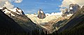 Anniversary Peak (left), Hound's Tooth/Marmolata Spire (centered) in Bugaboo Glacier, and Snowpatch Spire (right). East aspect.
 -
 Anniversary Peak (left), with Hound's Tooth/Marmolata Spire to right.
 -
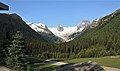 View from the Bugaboos Lodge. Left to rightː Anniversary Peak, Hound's Tooth, Bugaboo Glacier, and Snowpatch Spire.
 -
 Anniversary Peak (left of center) and Marmolata Mountain seen from Applebee Dome
 -


See also
- The Bugaboos
- Geography of British Columbia
 Mountains portal

References
- ^ a b "Anniversary Peak, British Columbia". Peakbagger.com. Retrieved 2023-02-05.
- ^ a b "Anniversary Peak, Peakvisor.com". Retrieved 2023-02-05.
- ^ a b "Anniversary Peak". Geographical Names Data Base. Natural Resources Canada. Retrieved 2023-02-05.
- ^ a b Mary Caperton Morton (2017), Aerial Geology; A High-Altitude Tour of North America's Spectacular Volcanoes, Canyons, Glaciers, Lakes, Craters, and Peaks, Timber Press, ISBN 9781604698350, p. 42
- ^ a b "Anniversary Peak". BC Geographical Names. Retrieved 2023-02-05.
- ^ "North America, Canada, Bugaboos Camp of the A.A.C., Americanalpineclub.org". Retrieved 2023-02-05.
- ^ William Lowell Putnam, Glen W. Boles, Roger W. Laurilla (1990), Place names of the Canadian Alps, Publisher:Footprint, ISBN 9780969162148, p. 10
- ^ Peel, M. C.; Finlayson, B. L.; McMahon, T. A. (2007). "Updated world map of the Köppen−Geiger climate classification". Hydrol. Earth Syst. Sci. 11: 1633–1644. ISSN 1027-5606.
External links
- Anniversary Peak: weather
- v
- t
- e
Places adjacent to Anniversary Peak
| Marmolata Spire | Hound's Tooth | Frenchman Mountain |
 | ||
| Flattop Peak |  Anniversary Peak Anniversary Peak | Bugaboo Creek |
 | ||
| Howser Peak | Bugaboo Pass |


