Bandudato
You can help expand this article with text translated from the corresponding article in German. (July 2012) Click [show] for important translation instructions.
- View a machine-translated version of the German article.
- Machine translation, like DeepL or Google Translate, is a useful starting point for translations, but translators must revise errors as necessary and confirm that the translation is accurate, rather than simply copy-pasting machine-translated text into the English Wikipedia.
- Do not translate text that appears unreliable or low-quality. If possible, verify the text with references provided in the foreign-language article.
- You must provide copyright attribution in the edit summary accompanying your translation by providing an interlanguage link to the source of your translation. A model attribution edit summary is
Content in this edit is translated from the existing German Wikipedia article at [[:de:Bandudato]]; see its history for attribution. - You may also add the template
{{Translated|de|Bandudato}}to the talk page. - For more guidance, see Wikipedia:Translation.
Suco in Aileu, East Timor
Bandudato | |
|---|---|
 Raelete, Bandudato | |
 Sucos of Aileu District | |
| Country |  East Timor East Timor |
| District | Aileu |
| Subdistrict | Aileu |
| Area | |
| • Total | 30.65 km2 (11.83 sq mi) |
| Population (2010) | |
| • Total | 1,426 |
| Time zone | UTC +9 |
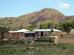
Bandudato is a suco of Aileu subdistrict, Aileu District, East Timor.[1] The administrative area covers an area of 30.65 square kilometres and at the time of the 2010 census it had a population of 1,426 people. [2]
See also
References
- ^ "PUBLICAÇÃO OFICIAL DA REPÚBLICA DEMOCRÁTICA DE TIMOR - LESTE" (PDF). Jornal da República, Government of East Timor. 16 September 2009. Archived from the original (PDF) on 1 March 2012. Retrieved 21 July 2012.
- ^ "Census" (PDF). Direcção Nacional de Estatística. Archived from the original (PDF) on 10 October 2011. Retrieved 21 July 2012.
8°45′48″S 125°34′09″E / 8.7633°S 125.5692°E / -8.7633; 125.5692
 | This East Timor location article is a stub. You can help Wikipedia by expanding it. |
- v
- t
- e


 Bandudatu