Binnenstad, Maastricht
Neighborhood of Maastricht in Netherlands, Limburg
Binnenstad | |
|---|---|
Neighborhood of Maastricht | |
 Location of Binnenstad in Maastricht | |
| Municipality | Maastricht |
| Province | Limburg |
| Country | Netherlands |
| Area | |
| • Total | 34 ha (84 acres) |
| Population | |
| • Total | 1,645 |
| • Density | 4,800/km2 (13,000/sq mi) |
Binnenstad (Dutch pronunciation: [ˈbɪnə(n)ˌstɑt]; Limburgish: Binnestad [ˈbɪnəˌstɑt]; English: Inner city) is a neighbourhood in Maastricht, Netherlands. Until 2007, it was officially named City. As its name suggests, it is the most centrally located area of Maastricht.
Notable features
- Dinghuis, a Medieval courthouse
- The Dominicanenkerk (Dominican Church), a former church now housing a book shop
- Entre Deux, a newly rebuilt shopping centre
- The 'Hoge Brug/Hoeg Brögk' (High Bridge, built 2003), connecting the Binnenstad to Wyck-Céramique
- The Markt with the city hall of Maastricht
- The Onze-Lieve-Vrouweplein with the Basilica of Our Lady, Maastricht (Basiliek van Onze-Lieve-Vrouw-Tenhemelopneming)
- The Vrijthof with the Basilica of Saint Servatius (Sint-Servaasbasiliek) and Protestant Sint-Janskerk
- Treasury of the Basilica of Saint Servatius
- Sint Servaasbrug, 13th-century arch-bridge over the Maas
- The Stokstraat area (Stokstraatkwartier)
Impressions
-
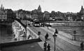 Historic picture of the Binnenstad seen from the opposite bank of the Maas
 -
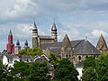 Panorama, with three churches (Onze-Lieve-Vrouwekerk, Sint-Janskerk and Sint-Servaasbasiliek)
 -
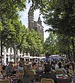
 Pubs on the Vrijthof square
 -
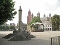 View of the Vrijthof square, with the Maastrichtian perron in the foreground
 -
 Shop in the Stokstraatkwartier
 -
 The Onze-Lieve-Vrouweplein
 -
 Dinghuis and the Kleine Staat street, as it looked in 1957


Location
- v
- t
- e
Neighbouring areas
| Statenkwartier | Boschstraatkwartier | Sint Maartenspoort |
 | ||
| Kommelkwartier |  Binnenstad Binnenstad | Wyck-Céramique |
 | ||
| Kommelkwartier | Jekerkwartier | Jekerkwartier |
| ||||||||
|---|---|---|---|---|---|---|---|---|
| Culture |
|  | ||||||
| Geography |
| |||||||
| Politics |
| |||||||
| Sports | ||||||||
| Transportation |
| |||||||


50°50′59″N 5°41′20″E / 50.8498°N 5.6890°E / 50.8498; 5.6890


 Binnenstad,_Maastricht