Blue Glacier to Cape Chocolate Important Bird Area
Important Bird Area in Antarctica
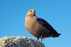
The Blue Glacier to Cape Chocolate Important Bird Area is a 1,206 ha tract of ice-free land running for 10 km south from Blue Glacier towards Cape Chocolate along the Scott Coast of southern Victoria Land, Antarctica. It has been identified as an Important Bird Area (IBA) by BirdLife International because in 1981 it supported an estimated 226 breeding pairs of south polar skuas. It lies within the McMurdo Dry Valleys Antarctic Specially Managed Area.[1]
References
- ^ "Blue Glacier to Cape Chocolate". BirdLife Data Zone. BirdLife International. 2015. Retrieved 25 October 2020.
77°53′30″S 164°30′18″E / 77.89167°S 164.50500°E / -77.89167; 164.50500
- v
- t
- e
Important Bird Areas of Antarctica
- Berkner Island
- Coalseam Cliffs
- Mount Faraway
- Stewart Buttress
- Dawson-Lambton Glacier
- Luitpold Coast
- Stancomb-Wills Glacier
- Amanda Bay
- Bluff Island
- Boyd Island
- Caro Island
- Donskiye Islands
- Filla Island
- Gardner Island
- Hop Island
- Kazak Island
- Lucas Island
- Lugg Island
- Magnetic Island
- Rookery Lake
- Tryne Islands
- Turner Island
- Warriner Island
- Waterhouse Island
- West Ice Shelf
- Zolotov Island
- Arthurson Ridge
- Kartografov Island
- Mount Archer
- Sturge Island
- Adélie Cove
- Blue Glacier to Cape Chocolate
- Cape Adare
- Cape Main
- Cape Roget
- Cape Wadworth
- Cape Washington
- Cotter Cliffs
- Dailey Islands
- Depot Island
- Downshire Cliffs
- Duke of York Island
- Dunlop Island
- Edmonson Point
- Foyn Island
- Gregory Island
- Inexpressible Island
- Mandible Cirque
- Possession Islands
- Seabee Hook
- Brownson Islands
- Edwards Islands
- Hummer Point
- Lindsey Islands
- Maher Island
- Mathewson Point
- Mount Paterson
- Thurston Glacier
- Worley Point
- Ambush Bay
- Apéndice Island
- Armstrong Reef
- Avian Island
- Bates Island
- Brash Island
- Brown Bluff
- Cape Evensen
- Cape Wollaston
- Cierva Point
- Cockburn Island
- Cormorant Island
- Cuverville Island
- D'Urville Monument
- Danger Islands
- Devil Island
- Dion Islands
- Dodman Island
- Dream Island
- Duroch Islands
- Earle Island
- Eden Rocks
- Emperor Island
- Gerlache Island
- Ginger Islands
- Gourdin Island
- Guépratte Island
- Hope Bay
- Joubin Islands
- Lagotellerie Island
- Litchfield Island
- Madder Cliffs
- Midas Island
- Moss Islands
- Murray Island
- Paulet Island
- Pearl Rocks
- Penguin Point
- Petermann Island
- Pursuit Point
- Rosenthal Islands
- Ryder Bay Islands
- Snow Hill Island
- Stonington Island
- Trinity Island
- Tupinier Islands
- Uruguay Island
- Admiralty Bay
- Ardley Island
- Aspland Island
- Baily Head
- Barnard Point
- Byers Peninsula
- Cape Bowles
- Cape Garry
- Cape Hooker
- Cape Lookout
- Cape Melville
- Cape Shirreff
- Cape Wallace
- Chinstrap Cove
- Eadie Island
- East of Nelly Point
- Eastern Litwin Bay
- Escarpada Point
- False Round Point
- Fur Seal Point
- Gibbs Island
- Half Moon Island
- Harmony Point
- Heywood Island
- Jameson Point
- Kellick Island
- Lions Rump
- Milosz Point
- Mount Elder
- North Foreland
- O'Brien Island
- Owen Island
- Penguin Island
- Point Hennequin
- Point Wordie
- Potter Peninsula
- Pottinger Point
- Saddleback Point
- Seal Islands
- Stinker Point
- Sugarloaf Island
- Tartar Island
- Vapour Col
- Walker Point
- Yankee Harbour
- Atriceps Island
- Buchanan Point
- Cape Davidson
- Cape Hansen
- Cape Robertson
- Cape Whitson
- Cheal Point
- Christoffersen Island
- Eillium Island
- Ferguslie Peninsula
- Ferrier Peninsula
- Fraser Point
- Fredriksen Island
- Gibbon Bay
- Gosling Islands
- Graptolite Island
- Grey Island
- Inaccessible Islands
- Larsen Islands
- Matthews Island
- Michelsen Island
- Moe Island
- Moreton Point
- Pirie Peninsula
- Point Martin
- Return Point
- Robertson Islands
- Shingle Cove
- Signy Island
- Skilling Island
- Southern Powell Island
- Watson Peninsula
- Weddell Islands
This Victoria Land location article is a stub. You can help Wikipedia by expanding it. |
- v
- t
- e