Fourmile, Kentucky
Unincorporated community in Kentucky, United States
Unincorporated community in Kentucky, United States
36°47′33″N 83°44′34″W / 36.79250°N 83.74278°W / 36.79250; -83.7427840939
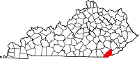
Fourmile is an unincorporated community located in Bell County, Kentucky.
Fourmile appears on the Pineville U.S. Geological Survey Map.[1]
Geography
Fourmile is located at 36°47′33″N 83°44′34″W / 36.79250°N 83.74278°W / 36.79250; -83.74278. Fourmile is along the Cumberland River.
History
A post office was established in the community in 1899. The origins of the name Fourmile are disputed: some hold it is because of hamlet's location four miles downriver from Pineville, while others believe it was named after the four-mile length of nearby Fourmile Creek.[2]
References
- v
- t
- e
Municipalities and communities of Bell County, Kentucky, United States
County seat: Pineville
- Middlesboro
- Pineville
- Arjay
unincorporated
communities
- Balkan
- Black Snake
- Blackmont
- Calvin
- Clear Creek Springs
- Colmar
- Cubage
- Field
- Fonde
- Fourmile
- Frakes
- Harbell
- Hutch
- Ingram
- Jaybel
- Keenox
- Kettle Island
- Meldrum
- Miracle
- Noetown
- Oaks
- Olcott
- Ponza
- Premier
- Pruden‡
- Red Oak
- Rella
- Stoney Fork
- Stony Fork Junction
- Tejay
- Timsley
- Tuggleville
- Varilla
- Wallsend
- Wasioto
(and the creeks
they are on)
- Red Bird River (includes Red Bird/Nuckles/Beverly)
‡This populated place also has portions in an adjacent county or counties
- Kentucky portal
- United States portal


