Gega, Bulgaria
You can help expand this article with text translated from the corresponding article in Bulgarian. (March 2018) Click [show] for important translation instructions.
- View a machine-translated version of the Bulgarian article.
- Machine translation, like DeepL or Google Translate, is a useful starting point for translations, but translators must revise errors as necessary and confirm that the translation is accurate, rather than simply copy-pasting machine-translated text into the English Wikipedia.
- Do not translate text that appears unreliable or low-quality. If possible, verify the text with references provided in the foreign-language article.
- You must provide copyright attribution in the edit summary accompanying your translation by providing an interlanguage link to the source of your translation. A model attribution edit summary is
Content in this edit is translated from the existing Bulgarian Wikipedia article at [[:bg:Гега (село)]]; see its history for attribution. - You may also add the template
{{Translated|bg|Гега (село)}}to the talk page. - For more guidance, see Wikipedia:Translation.
Village in Blagoevgrad, Bulgaria
Gega Гега | |
|---|---|
Village | |
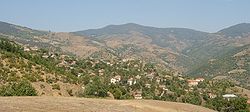 Panoramic view of the village | |
| 41°27′0″N 23°00′0″E / 41.45000°N 23.00000°E / 41.45000; 23.00000 | |
| Country |  Bulgaria Bulgaria |
| Province | Blagoevgrad |
| Municipality | Petrich |
| Area | |
| • Total | 15,772 km2 (6,090 sq mi) |
| Elevation | 700 m (2,300 ft) |
| Population (2015) | |
| • Total | 247 |
| Time zone | UTC+2 (EET) |
| • Summer (DST) | UTC+3 (EEST) |
| Postal code | 2882 |
| Area code | 074204 |
| Vehicle registration | Е |
Gega (Bulgarian: Гега [ˈɡɛɡɐ]) is a village in Petrich Municipality, in Blagoevgrad Province, Bulgaria.[1] As of 2013, it had a population of 219.[2]
References
- v
- t
- e
Petrich MunicipalityCapital: Petrich
- Baskaltsi
- Belasitsa
- Bogoroditsa
- Borovichene
- Chuchuligovo
- Churicheni
- Churilovo
- Dolene
- Dolna Krushitsa
- Dolna Ribnitsa
- Dolno Spanchevo
- Dragush
- Drangovo
- Drenovitsa
- Drenovo
- Gabrene
- Gega
- General Todorov
- Gorchevo
- Ivanovo
- Karnalovo
- Kavrakirovo
- Kamena
- Kapatovo
- Kladentsi
- Klyuch
- Kolarovo
- Krandzhilitsa
- Kromidovo
- Kukurahtsevo
- Kulata
- Marikostinovo
- Marino Pole
- Mendovo
- Mitino
- Mihnevo
- Novo Konomladi
- Parvomay
- Pravo Bardo
- Ribnik
- Rupite
- Razhdak
- Samuilova Krepost
- Samuilovo
- Skrat
- Starchevo
- Strumeshnitsa
- Tonsko Dabe
- Topolnitsa
- Vishlene
- Volno
- Yavornitsa
- Yakovo
- Zoychene
- Churilovo Monastery
- Heraclea Sintica
- Kozhuh
- Samuil's Fortress
- Tsar Samuil Stadium
41°27′N 23°00′E / 41.450°N 23.000°E / 41.450; 23.000
 | This Blagoevgrad Province, Bulgaria location article is a stub. You can help Wikipedia by expanding it. |
- v
- t
- e


