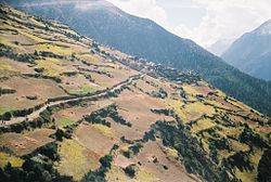
Ghyaru
Village development committee in Gandaki Zone, Nepal
Ghyaru घ्यारु | |
|---|---|
Village development committee | |
 | |
| 28°40′N 84°09′E / 28.66°N 84.15°E / 28.66; 84.15 | |
| Country |  Nepal Nepal |
| Zone | Gandaki Zone |
| District | Manang District |
| Elevation | 3,730 m (12,240 ft) |
| Population (2011)[1] | |
| • Total | 71 |
| Time zone | UTC+5:45 (Nepal Time) |
Ghyaru is a village development committee in Manang District in the Gandaki Zone of northern Nepal. At the time of the 2011 Nepal census it had a population of 71 people living in 33 individual households.[2]

References
- ^ "National Population and Housing Census 2011(Village Development Committee/Municipality)" (PDF). Government of Nepal. National Planning Commission. November 2012. Archived from the original (PDF) on 2018-10-05. Retrieved 2017-01-18.
- ^ "Nepal Census 2001", Nepal's Village Development Committees, Digital Himalaya, archived from the original on 12 October 2008, retrieved 15 November 2009.
- v
- t
- e
Manang District
Headquarters: Chame Rural Municipality
- Chame
- Nason
- Narpa Bhumi
- Nesyang

 | This article about a location in the Manang District of Nepal is a stub. You can help Wikipedia by expanding it. |
- v
- t
- e


