Grade II* listed buildings in Sedgemoor

Sedgemoor is a local government district in the English county of Somerset. In the United Kingdom, the term listed building refers to a building or other structure officially designated as being of special architectural, historical or cultural significance; Grade II* structures are those considered to be "particularly significant buildings of more than local interest".[1] Listing was begun by a provision in the Town and Country Planning Act 1947. Once listed, severe restrictions are imposed on the modifications allowed to a building's structure or its fittings. In England, the authority for listing under the Planning (Listed Buildings and Conservation Areas) Act 1990 rests with Historic England, a non-departmental public body sponsored by the Department for Digital, Culture, Media and Sport; local authorities have a responsibility to regulate and enforce the planning regulations.[2]
Sedgemoor is a low-lying area of land close to sea level between the Quantock and Mendip hills, historically largely marsh (or moor). It contains the bulk of the area also known as the Somerset Levels, including one of Europe's oldest known engineered roadways, the Sweet Track.[3]
There are 90 Grade II* listed buildings in Sedgemoor. The oldest buildings in the list are Anglo-Saxon and Norman churches, with many more churches and churchyard crosses from the Middle Ages. There are also medieval country houses and the remains of castles. Urban architecture is represented by King Square in Bridgwater. Industrial buildings include Ashton Windmill which was built in the 18th century, on a site which has been the location of a windmill since the medieval period.[4] In Bridgwater the Chandos Glass Cone and Brick Kiln are parts of its industrial history.[5][6] Related transport structures include Bridgwater railway station and the Telescopic Bridge carrying the railway over the River Parrett.[7][8] The history of the drainage of the Somerset Levels is on display at the Westonzoyland Pumping Station Museum.[9] One of the first buildings to make extensive use of Portland cement for pre-cast concrete was Castle House in Bridgwater which was built in 1851.[10] Decorative work in Bridgwater is also represented with the inclusion of the Blake Statue and War Memorial.[11][12]
Map all coordinates using OpenStreetMap
Download coordinates as:
- KML
- GPX (all coordinates)
- GPX (primary coordinates)
- GPX (secondary coordinates)
Buildings
| Name | Location | Type | Completed [note 1] | Grid ref.[note 2] Geo-coordinates | Entry number [note 3] | Image | Ref. |
|---|---|---|---|---|---|---|---|
| Ashton Windmill | Chapel Allerton | Windmill | 18th century | ST414502 51°14′56″N 2°50′24″W / 51.2488°N 2.8401°W / 51.2488; -2.8401 (Ashton Windmill) | 1173522 |  More images | [13] |
| King John's Hunting Lodge (Axbridge Museum) | Axbridge | House | Early 16th century | ST430545 51°17′14″N 2°49′03″W / 51.2871°N 2.8176°W / 51.2871; -2.8176 (King John's Hunting Lodge (Axbridge Museum)) | 1059142 | 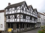 More images | [14] |
| Baptist Church | Bridgwater | Church | c. 1837 | ST297369 51°07′38″N 3°00′17″W / 51.1272°N 3.0046°W / 51.1272; -3.0046 (Baptist Church) | 1298798 |  More images | [15] |
| Barford House and outbuilding wing at rear | Enmore | Farmhouse | c. 1710 | ST233358 51°07′02″N 3°05′47″W / 51.1171°N 3.0965°W / 51.1171; -3.0965 (Barford House and outbuilding wing at rear) | 1058941 | 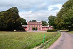 More images | [16] |
| Beere Manor Farmhouse and attached barn | Cannington | Cross passage house | 16th or 17th century | ST240414 51°10′01″N 3°05′15″W / 51.1670°N 3.0875°W / 51.1670; -3.0875 (Beere Manor Farmhouse and attached barn) | 1059062 |  Upload Photo | [17] |
| Blake Statue | Bridgwater | Statue | 1898 | ST298370 51°07′42″N 3°00′13″W / 51.1284°N 3.0036°W / 51.1284; -3.0036 (Blake Statue) | 1205747 | 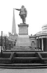 More images | [18] |
| Boomer Farmhouse | North Petherton | Farmhouse | 1681 | ST277328 51°05′27″N 3°01′59″W / 51.0908°N 3.0331°W / 51.0908; -3.0331 (Boomer Farmhouse) | 1344987 |  More images | [19] |
| Brick Kiln | Bridgwater | Kiln | 19th century | ST299376 51°08′01″N 3°00′07″W / 51.1337°N 3.0019°W / 51.1337; -3.0019 (Brick Kiln) | 1206110 | 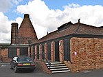 More images | [20] |
| Bridgwater Railway Station | Bridgwater | Bridge | 1841 | ST307369 51°07′40″N 2°59′25″W / 51.1278°N 2.9904°W / 51.1278; -2.9904 (Bridgwater Railway Station) | 1187364 |  More images | [21] |
| Castle House | Bridgwater | House | 1851 | ST299371 51°07′45″N 3°00′07″W / 51.1291°N 3.0020°W / 51.1291; -3.0020 (Castle House) | 1355168 |  More images | [22] |
| Castle House with adjoining wings & Gate Cottage | Enmore | House | 18th century | ST243348 51°06′30″N 3°04′53″W / 51.1084°N 3.0815°W / 51.1084; -3.0815 (Castle House with adjoining wings & Gate Cottage) | 1177302 |  More images | [23] |
| Castle wall, watergate and undercroft | Bridgwater | Curtain wall | 13th century | ST299372 51°07′48″N 3°00′07″W / 51.1301°N 3.0020°W / 51.1301; -3.0020 (Castle wall, watergate and undercroft) | 1207427 | Upload Photo | [24] |
| Christ Church Unitarian Chapel | Bridgwater | Schoolroom | 19th century | ST299369 51°07′38″N 3°00′08″W / 51.1273°N 3.0022°W / 51.1273; -3.0022 (Christ Church Unitarian Chapel) | 1197371 |  More images | [25] |
| Church Cross in churchyard, 10 metres south of Church of St Andrew | Compton Bishop | Cross | 15th century | ST395553 51°17′39″N 2°52′04″W / 51.2943°N 2.8677°W / 51.2943; -2.8677 (Church Cross in churchyard, 10 metres south of Church of St Andrew) | 1344903 |  More images | [26] |
| Church Farm House and Church Farmhouse | Cheddar | Farmhouse | 15th century | ST460530 51°16′25″N 2°46′31″W / 51.2737°N 2.7752°W / 51.2737; -2.7752 (Church Farm House and Church Farmhouse) | 1344877 | Upload Photo | [27] |
| Church of All Saints | Ashcott | Church | 15th century | ST437371 51°07′51″N 2°48′21″W / 51.1308°N 2.8057°W / 51.1308; -2.8057 (Church of All Saints) | 1058957 |  More images | [28] |
| Church of All Saints | Otterhampton | Church | 12th century | ST246431 51°10′59″N 3°04′47″W / 51.1830°N 3.0797°W / 51.1830; -3.0797 (Church of All Saints) | 1344927 |  More images | [29] |
| Church of All Saints | Aisholt | Church | 14th century | ST193356 51°06′51″N 3°09′12″W / 51.1143°N 3.1533°W / 51.1143; -3.1533 (Church of All Saints) | 1178112 |  More images | [30] |
| Church of St Bridget | Brean | Church | 13th century | ST296559 51°17′54″N 3°00′36″W / 51.2983°N 3.0099°W / 51.2983; -3.0099 (Church of St Bridget) | 1262963 |  More images | [31] |
| Church of St Giles | Thurloxton | Church | 14th and 15th century | ST274304 51°04′07″N 3°02′12″W / 51.0686°N 3.0367°W / 51.0686; -3.0367 (Church of St Giles) | 1295089 |  More images | [32] |
| Church of St John the Baptist | Biddisham | Church | 13th century | ST381534 51°16′36″N 2°53′15″W / 51.2767°N 2.8876°W / 51.2767; -2.8876 (Church of St John the Baptist) | 1059138 |  More images | [33] |
| Church of St John the Baptist | Bridgwater | Church | 1843 | ST303373 51°07′52″N 2°59′49″W / 51.1311°N 2.9969°W / 51.1311; -2.9969 (Church of St John the Baptist) | 1197354 |  More images | [34] |
| Church of St Martin | Fiddington | Church | 11th century | ST215405 51°09′33″N 3°07′23″W / 51.1592°N 3.1230°W / 51.1592; -3.1230 (Church of St Martin) | 1264213 |  More images | [35] |
| Church of St Mary | Cossington | Church | 13th century | ST356402 51°09′29″N 2°55′17″W / 51.1581°N 2.9215°W / 51.1581; -2.9215 (Church of St Mary) | 1344698 | 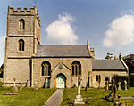 More images | [36] |
| Church of St Mary the Virgin | Nether Stowey | Church | 15th century | ST196396 51°09′01″N 3°08′59″W / 51.1503°N 3.1498°W / 51.1503; -3.1498 (Church of St Mary the Virgin) | 1344922 | 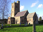 More images | [37] |
| Church of St Michael | Enmore | Church | 19th century | ST239352 51°06′40″N 3°05′14″W / 51.1111°N 3.0873°W / 51.1111; -3.0873 (Church of St Michael) | 1177223 |  More images | [38] |
| Church of St Michael and All Angels | Bawdrip | Church | 13th century | ST341395 51°09′06″N 2°56′34″W / 51.1517°N 2.9429°W / 51.1517; -2.9429 (Church of St Michael and All Angels) | 1060158 | 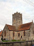 More images | [39] |
| Church of St Michael and All Angels | Rowberrow | Church | 14th century | ST449586 51°19′26″N 2°47′29″W / 51.3240°N 2.7915°W / 51.3240; -2.7915 (Church of St Michael and All Angels) | 1296019 |  More images | [40] |
| Church of St Peter | North Newton | Church | Saxon | ST301311 51°04′31″N 2°59′56″W / 51.0753°N 2.9990°W / 51.0753; -2.9990 (Church of St Peter) | 1058917 |  More images | [41] |
| Church of St Peter and St Paul, Over Stowey | Over Stowey | Church | 1840 | ST185385 51°08′24″N 3°09′56″W / 51.1400°N 3.1655°W / 51.1400; -3.1655 (Church of St Peter and St Paul, Over Stowey) | 1060177 |  More images | [42] |
| Church of the Blessed Virgin Mary | Shapwick | Church | 1331 | ST417382 51°08′26″N 2°50′01″W / 51.1405°N 2.8337°W / 51.1405; -2.8337 (Church of the Blessed Virgin Mary) | 1058962 |  More images | [43] |
| Church of the Holy Trinity | Chilton Trinity | Church | 13th century | ST296391 51°08′51″N 3°00′26″W / 51.1474°N 3.0072°W / 51.1474; -3.0072 (Church of the Holy Trinity) | 1264231 |  More images | [44] |
| Churchyard Cross in churchyard approximately 10 metres south of nave, Church of St Gregory | Weare | Cross | 15th century | ST414526 51°16′13″N 2°50′28″W / 51.2702°N 2.8412°W / 51.2702; -2.8412 (Churchyard Cross in churchyard approximately 10 metres south of nave, Church of St Gregory) | 1059090 |  More images | [45] |
| Churchyard Cross in churchyard, 30 metres east of East End, Church of St Mary | Wedmore | Cross | 15th century | ST435479 51°13′40″N 2°48′37″W / 51.2278°N 2.8103°W / 51.2278; -2.8103 (Churchyard Cross in churchyard, 30 metres east of East End, Church of St Mary) | 1252634 | 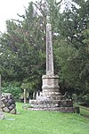 More images | [46] |
| Churchyard Cross | Broomfield | Cross | 13th century | ST224320 51°04′56″N 3°06′31″W / 51.0822°N 3.1087°W / 51.0822; -3.1087 (Churchyard Cross) | 1058938 |  More images | [47] |
| Churchyard Cross in churchyard, Church of St Michael | Enmore | Cross | 15th century | ST239351 51°06′40″N 3°05′14″W / 51.1110°N 3.0872°W / 51.1110; -3.0872 (Churchyard Cross in churchyard, Church of St Michael) | 1344998 |  More images | [48] |
| Churchyard Cross, in churchyard, 5 metres south of South Porch, Church of St John the Baptist | Biddisham | Cross | Late 14th century | ST381534 51°16′36″N 2°53′15″W / 51.2766°N 2.8875°W / 51.2766; -2.8875 (Churchyard Cross, in churchyard, 5 metres south of South Porch, Church of St John the Baptist) | 1173427 |  | [49] |
| Clerks Cottage | Spaxton | House | 16th or 17th century | ST231361 51°07′08″N 3°06′00″W / 51.1190°N 3.0999°W / 51.1190; -3.0999 (Clerks Cottage) | 1344669 | Upload Photo | [50] |
| Coleridge's Cottage | Nether Stowey | House | 17th century | ST191398 51°09′08″N 3°09′29″W / 51.1522°N 3.1580°W / 51.1522; -3.1580 (Coleridge's Cottage) | 1344921 | 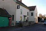 More images | [51] |
| Compton House and Forecourt Railings | Axbridge | Manor house | Early 17th century | ST426546 51°17′16″N 2°49′26″W / 51.2878°N 2.8239°W / 51.2878; -2.8239 (Compton House and Forecourt Railings) | 1173405 | 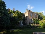 More images | [52] |
| County Court Office | Bridgwater | Office | 1824 | ST299371 51°07′45″N 3°00′09″W / 51.1293°N 3.0024°W / 51.1293; -3.0024 (County Court Office) | 1197407 |  More images | [53] |
| Court House Farmhouse | Spaxton | Farmhouse | 15th or 16th century | ST225370 51°07′40″N 3°06′31″W / 51.1278°N 3.1086°W / 51.1278; -3.1086 (Court House Farmhouse) | 1344667 |  More images | [54] |
| Crosse Family Monument in churchyard about 1 metre south of nave, Church of St Mary and All Saints | Broomfield | Chest tomb | 1653 | ST224320 51°04′56″N 3°06′32″W / 51.0822°N 3.1088°W / 51.0822; -3.1088 (Crosse Family Monument in churchyard about 1 metre south of nave, Church of St Mary and All Saints) | 1344997 | Upload Photo | [55] |
| Dovecote in grounds of Shapwick Manor | Shapwick | Dovecote | Medieval | ST417383 51°08′30″N 2°50′01″W / 51.1418°N 2.8337°W / 51.1418; -2.8337 (Dovecote in grounds of Shapwick Manor) | 1190558 |  | [56] |
| Durleigh Church | Durleigh | Church | 11th century | ST274361 51°07′12″N 3°02′15″W / 51.1199°N 3.0375°W / 51.1199; -3.0375 (Durleigh Church) | 1177147 |  More images | [57] |
| Edington House | Edington | Farmhouse | c. 1640 | ST385396 51°09′09″N 2°52′49″W / 51.1524°N 2.8802°W / 51.1524; -2.8802 (Edington House) | 1344661 | Upload Photo | [58] |
| Farm Estate Farmhouse | Fiddington | Farmhouse | 16th century | ST223417 51°10′12″N 3°06′46″W / 51.1699°N 3.1127°W / 51.1699; -3.1127 (Farm Estate Farmhouse) | 1237276 | Upload Photo | [59] |
| Former Market Cross in churchyard, Church of St Mark | Mark | Market cross | 15th century | ST380478 51°13′35″N 2°53′19″W / 51.2264°N 2.8886°W / 51.2264; -2.8886 (Former Market Cross in churchyard, Church of St Mark) | 1252188 |  More images | [60] |
| Gazebo and attached walling bounding grounds of Stowey Court | Nether Stowey | Gate | Early 18th century | ST195396 51°09′00″N 3°09′06″W / 51.1500°N 3.1517°W / 51.1500; -3.1517 (Gazebo and attached walling bounding grounds of Stowey Court) | 1264119 |  More images | [61] |
| Great House Farmhouse and flanking walls | Wedmore | Farmhouse | 1670 | ST453464 51°12′53″N 2°47′00″W / 51.2146°N 2.7833°W / 51.2146; -2.7833 (Great House Farmhouse and flanking walls) | 1252915 | Upload Photo | [62] |
| Legion House and attached wall to right | Bridgwater | Terrace | Mid 18th century | ST299371 51°07′45″N 3°00′10″W / 51.1293°N 3.0029°W / 51.1293; -3.0029 (Legion House and attached wall to right) | 1280623 |  More images | [63] |
| Manor House | Lympsham | Manor house | Mid 18th century | ST334542 51°17′00″N 2°57′20″W / 51.2832°N 2.9556°W / 51.2832; -2.9556 (Manor House) | 1262680 | Upload Photo | [64] |
| Market Cross | Cheddar | Market cross | 15th century | ST459532 51°16′31″N 2°46′36″W / 51.2754°N 2.7767°W / 51.2754; -2.7767 (Market Cross) | 1173642 |  More images | [65] |
| Maunsel House | North Petherton | House | Later 15th century | ST304300 51°03′55″N 2°59′38″W / 51.0654°N 2.9940°W / 51.0654; -2.9940 (Maunsel House) | 1177930 |  More images | [66] |
| No 10 King Square and attached railings | Bridgwater | House | Late 18th or early 19th century | ST298371 51°07′47″N 3°00′13″W / 51.1296°N 3.0035°W / 51.1296; -3.0035 (No 10 King Square and attached railings) | 1297163 |  | [67] |
| No 13 King Square and attached railings | Bridgwater | House | c. 1770–1800 | ST2987337198 51°07′47″N 3°00′13″W / 51.129748°N 3.003551°W / 51.129748; -3.003551 (No 13 King Square and attached railings) | 1197394 |  | [68] |
| No 14 King Square and attached railings | Bridgwater | House | c. 1770–1800 | ST298372 51°07′47″N 3°00′13″W / 51.1298°N 3.0036°W / 51.1298; -3.0036 (No 14 King Square and attached railings) | 1280095 |  | [69] |
| No 15 Frian Street and attached front railings and rear garden walls | Bridgwater | Town house | c. 1700 | ST298368 51°07′36″N 3°00′13″W / 51.1268°N 3.0035°W / 51.1268; -3.0035 (No 15 Frian Street and attached front railings and rear garden walls) | 1297157 | Upload Photo | [70] |
| 9 High Street | Axbridge | Timber framed house | 15th or 16th century | ST430545 51°17′14″N 2°49′05″W / 51.2871°N 2.8180°W / 51.2871; -2.8180 (9 High Street) | 1344893 |  More images | [71] |
| 45 and 47 St Mary Street | Bridgwater | House | 14th century | ST297369 51°07′39″N 3°00′18″W / 51.1274°N 3.0050°W / 51.1274; -3.0050 (45 and 47 St Mary Street) | 1052245 |  | [72] |
| 1 King Square | Bridgwater | House | c. 1770–1800 | ST298371 51°07′45″N 3°00′14″W / 51.1293°N 3.0039°W / 51.1293; -3.0039 (1 King Square) | 1197393 |  | [73] |
| 10 and 11, West Quay | Bridgwater | House | Early/mid 18th century | ST299372 51°07′47″N 3°00′07″W / 51.1298°N 3.0019°W / 51.1298; -3.0019 (10 and 11, West Quay) | 1197421 |  | [74] |
| 3–9 Chandos Street | Bridgwater | Terrace | Early 18th century | ST299372 51°07′48″N 3°00′10″W / 51.1301°N 3.0028°W / 51.1301; -3.0028 (3–9 Chandos Street) | 1205624 | 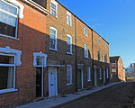 | [75] |
| 8 and 9 King Square | Bridgwater | Terrace | c. 1770–1800 | ST298371 51°07′46″N 3°00′13″W / 51.1294°N 3.0036°W / 51.1294; -3.0036 (8 and 9 King Square) | 1206644 |  | [76] |
| 2–7 King Square | Bridgwater | Terrace | c. 1770–1800 | ST298371 51°07′45″N 3°00′13″W / 51.1293°N 3.0037°W / 51.1293; -3.0037 (2–7 King Square) | 1280107 |  | [77] |
| Nos 11 and 12 King Square and attached railings | Bridgwater | Terrace | c. 1770–1800 | ST298371 51°07′47″N 3°00′13″W / 51.1296°N 3.0035°W / 51.1296; -3.0035 (Nos 11 and 12 King Square and attached railings) | 1206669 | 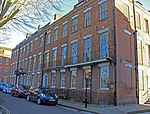 | [78] |
| Nos 16 and 17 King Square and attached railings | Bridgwater | House | c. 1770–1800 | ST298372 51°07′47″N 3°00′16″W / 51.1298°N 3.0044°W / 51.1298; -3.0044 (Nos 16 and 17 King Square and attached railings) | 1297164 |  | [79] |
| Old Manor House | Axbridge | Manor house | Early 17th century | ST430545 51°17′14″N 2°49′07″W / 51.2872°N 2.8186°W / 51.2872; -2.8186 (Old Manor House) | 1059147 |  | [80] |
| Patcombe Farmhouse including chimney stack adjoining south east | Broomfield | House | 1771 | ST247333 51°05′41″N 3°04′31″W / 51.0947°N 3.0753°W / 51.0947; -3.0753 (Patcombe Farmhouse including chimney stack adjoining south east) | 1060152 | Upload Photo | [81] |
| Paulet House (formerly known as Church Close) | Goathurst | House | 15th century | ST256343 51°06′14″N 3°03′47″W / 51.1038°N 3.0630°W / 51.1038; -3.0630 (Paulet House (formerly known as Church Close)) | 1058949 | Upload Photo | [82] |
| Rail Bridge over the River Parrett | Bridgwater | Railway bridge | 1871 | ST299374 51°07′54″N 3°00′06″W / 51.1318°N 3.0018°W / 51.1318; -3.0018 (Rail Bridge over the River Parrett) | 1297139 | 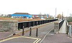 More images | [83] |
| Remains of Churchyard Cross in churchyard, about 23 metres north of North Aisle, Church of St Mary | North Petherton | Cross | 15th century | ST290330 51°05′32″N 3°00′53″W / 51.0923°N 3.0148°W / 51.0923; -3.0148 (Remains of Churchyard Cross in churchyard, about 23 metres north of North Aisle, Church of St Mary) | 1344990 | Upload Photo | [84] |
| Roadside Cross at Ngr St 4248 4966 (Stoughton Cross) | Wedmore | Wayside cross | 15th century | ST424496 51°14′36″N 2°49′31″W / 51.2432°N 2.8254°W / 51.2432; -2.8254 (Roadside Cross at Ngr St 4248 4966 (Stoughton Cross)) | 1252914 |  More images | [85] |
| Robin Hood's Hut | Goathurst | Kitchen | 1765 | ST254333 51°05′40″N 3°03′58″W / 51.0944°N 3.0660°W / 51.0944; -3.0660 (Robin Hood's Hut) | 1060155 |  More images | [86] |
| Shapwick House Hotel: The Granary | Shapwick | House | 1630 | ST416387 51°08′43″N 2°50′06″W / 51.1452°N 2.835°W / 51.1452; -2.835 (Shapwick House Hotel: The Granary) | 1190480 |  | [87] |
| Shapwick Manor | Shapwick | Manor house | Medieval | ST417384 51°08′32″N 2°50′03″W / 51.1422°N 2.8341°W / 51.1422; -2.8341 (Shapwick Manor) | 1190512 |  More images | [88] |
| St Judes | Axbridge | House | Late 15th century | ST430545 51°17′14″N 2°49′06″W / 51.2872°N 2.8184°W / 51.2872; -2.8184 (St Judes) | 1344894 |  More images | [89] |
| St Michael's Cheshire Home | Axbridge | House | Late 19th century | ST440548 51°17′23″N 2°48′12″W / 51.2896°N 2.8032°W / 51.2896; -2.8032 (St Michael's Cheshire Home) | 1425501 | Upload Photo | [90] |
| Stable block with coach house to Shapwick Manor | Shapwick | Stable | Mid 17th century | ST417384 51°08′33″N 2°50′00″W / 51.1424°N 2.8334°W / 51.1424; -2.8334 (Stable block with coach house to Shapwick Manor) | 1344994 | Upload Photo | [91] |
| Stawell Church | Stawell | Church | 13th century | ST368382 51°08′25″N 2°54′17″W / 51.1404°N 2.9047°W / 51.1404; -2.9047 (Stawell Church) | 1174228 | 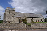 More images | [92] |
| Stone screen and flanking sections of walling enclosing former parterre on frontage of Shapwick Manor | Shapwick | Gate | 17th century | ST417384 51°08′32″N 2°50′02″W / 51.1423°N 2.8339°W / 51.1423; -2.8339 (Stone screen and flanking sections of walling enclosing former parterre on frontage of Shapwick Manor) | 1293774 | Upload Photo | [93] |
| Temple of Harmony | Goathurst | Garden temple | 1767 | ST251342 51°06′08″N 3°04′14″W / 51.1023°N 3.0705°W / 51.1023; -3.0705 (Temple of Harmony) | 1058952 |  More images | [94] |
| Blake Museum | Bridgwater | House | Late 15th or early 16th century | ST300368 51°07′38″N 3°00′06″W / 51.1271°N 3.0016°W / 51.1271; -3.0016 (Blake Museum) | 1205363 | 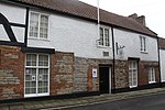 More images | [95] |
| The Old Angel | Axbridge | House | c. 1550 | ST431545 51°17′15″N 2°49′02″W / 51.2875°N 2.8173°W / 51.2875; -2.8173 (The Old Angel) | 1344883 |  More images | [96] |
| Tirelands Farmhouse | Enmore | Farmhouse | 15th century | ST241345 51°06′19″N 3°05′05″W / 51.1053°N 3.0848°W / 51.1053; -3.0848 (Tirelands Farmhouse) | 1177211 | Upload Photo | [97] |
| West Bower Manor with barn | Durleigh | Farmhouse | 15th century | ST265364 51°07′20″N 3°03′03″W / 51.1223°N 3.0507°W / 51.1223; -3.0507 (West Bower Manor with barn) | 1058940 |  More images | [98] |
| West Newton Manor with barn | North Petherton | Farmhouse | c. 1346 | ST288291 51°03′26″N 3°00′57″W / 51.0572°N 3.0159°W / 51.0572; -3.0159 (West Newton Manor with barn) | 1344642 | Upload Photo | [99] |
| Westonzoyland Engine Trust Old Pumping Station | Westonzoyland | Engine house | Early 19th century | ST339328 51°05′28″N 2°56′40″W / 51.0910°N 2.9445°W / 51.0910; -2.9445 (Westonzoyland Engine Trust Old Pumping Station) | 1174295 |  More images | [100] |
| Willis Family Monument | Goathurst | Chest tomb | 1765 | ST256343 51°06′12″N 3°03′48″W / 51.1034°N 3.0633°W / 51.1034; -3.0633 (Willis Family Monument) | 1344967 | Upload Photo | [101] |
| World War Memorial | Bridgwater | Statue | 1920s | ST298371 51°07′47″N 3°00′14″W / 51.1296°N 3.0040°W / 51.1296; -3.0040 (World War Memorial) | 1197395 |  More images | [102] |
See also
Notes
- ^ The date given is the date used by Historic England as significant for the initial building or that of an important part in the structure's description.
- ^ Sometimes known as OSGB36, the grid reference is based on the British national grid reference system used by the Ordnance Survey.
- ^ The "List Entry Number" is a unique number assigned to each listed building and scheduled monument by Historic England.
References
- ^ "Listed Buildings". Historic England. Archived from the original on 19 March 2017. Retrieved 23 August 2017.
- ^ "Planning (Listed Buildings and Conservation Areas) Act 1990 (c. 9)". Ministry of Justice. Archived from the original on 18 April 2010. Retrieved 17 December 2007.
- ^ "The day the Sweet Track was built". New Scientist. 16 June 1990. Archived from the original on 11 March 2010. Retrieved 26 October 2007.
- ^ Historic England. "Ashton Windmill (1173522)". National Heritage List for England. Retrieved 23 August 2017.
- ^ Historic England. "Chandos Glass Cone, at the junction of Northgate and Valetta Place (1019899)". National Heritage List for England. Retrieved 23 August 2017.
- ^ Historic England. "Brick and tile kiln west of East Quay, 200m east of Bridgwater Dock lock (1019900)". National Heritage List for England. Retrieved 23 August 2017.
- ^ Historic England. "Telescopic rail bridge over the River Parrett, 270m south east of Bridgwater Dock lock (1020624)". National Heritage List for England. Retrieved 6 April 2015.
- ^ Historic England. "Rail bridge over the River Parrett (1297139)". National Heritage List for England. Retrieved 6 April 2015.
- ^ Historic England. "Westonzoyland Engine Trust Old Pumping Station (1174295)". National Heritage List for England. Retrieved 6 April 2015.
- ^ Historic England. "Castle House (1355168)". National Heritage List for England. Retrieved 23 August 2017.
- ^ Historic England. "Blake Statue (1205747)". National Heritage List for England. Retrieved 23 August 2017.
- ^ Historic England. "World War Memorial (1197395)". National Heritage List for England. Retrieved 23 August 2017.
- ^ Historic England. "Ashton Windmill (1173522)". National Heritage List for England. Retrieved 3 April 2015.
- ^ Historic England. "King John's Hunting Lodge (Axbridge Museum) (1059142)". National Heritage List for England. Retrieved 7 July 2015.
- ^ Historic England. "Baptist Church (1298798)". National Heritage List for England. Retrieved 3 April 2015.
- ^ Historic England. "Barford House And Outbuilding Wing At Rear (1058941)". National Heritage List for England. Retrieved 3 April 2015.
- ^ Historic England. "Beere Manor Farmhouse And Attached Barn (1059062)". National Heritage List for England. Retrieved 3 April 2015.
- ^ Historic England. "Blake Statue (1205747)". National Heritage List for England. Retrieved 3 April 2015.
- ^ Historic England. "Boomer Farmhouse (1344987)". National Heritage List for England. Retrieved 3 April 2015.
- ^ Historic England. "Brick Kiln (1206110)". National Heritage List for England. Retrieved 3 April 2015.
- ^ Historic England. "Bridgwater Railway Station (1187364)". National Heritage List for England. Retrieved 3 April 2015.
- ^ Historic England. "Castle House (1355168)". National Heritage List for England. Retrieved 3 April 2015.
- ^ Historic England. "Castle House With Adjoining Wings Gate Cottage (1177302)". National Heritage List for England. Retrieved 3 April 2015.
- ^ Historic England. "Castle Wall, Watergate And Undercroft (1207427)". National Heritage List for England. Retrieved 3 April 2015.
- ^ Historic England. "Christ Church Unitarian Chapel (1197371)". National Heritage List for England. Retrieved 3 April 2015.
- ^ Historic England. "Church Cross, In Churchyard, 10 Metres South Of Church Of St Andrew (1344903)". National Heritage List for England. Retrieved 3 April 2015.
- ^ Historic England. "Church Farm House And Church Farmhouse (1344877)". National Heritage List for England. Retrieved 3 April 2015.
- ^ Historic England. "Church Of All Saints (1058957)". National Heritage List for England. Retrieved 3 April 2015.
- ^ Historic England. "Church Of All Saints (1344927)". National Heritage List for England. Retrieved 3 April 2015.
- ^ Historic England. "Church Of All Saints (1178112)". National Heritage List for England. Retrieved 3 April 2015.
- ^ Historic England. "Church Of St Bridget (1262963)". National Heritage List for England. Retrieved 3 April 2015.
- ^ Historic England. "Church Of St Giles (1295089)". National Heritage List for England. Retrieved 3 April 2015.
- ^ Historic England. "Church Of St John The Baptist (1059138)". National Heritage List for England. Retrieved 3 April 2015.
- ^ Historic England. "Church Of St John The Baptist (1197354)". National Heritage List for England. Retrieved 3 April 2015.
- ^ Historic England. "Church Of St Martin (1264213)". National Heritage List for England. Retrieved 3 April 2015.
- ^ Historic England. "Church Of St Mary (1344698)". National Heritage List for England. Retrieved 3 April 2015.
- ^ Historic England. "Church Of St Mary The Virgin (1344922)". National Heritage List for England. Retrieved 3 April 2015.
- ^ Historic England. "Church Of St Michael (1177223)". National Heritage List for England. Retrieved 3 April 2015.
- ^ Historic England. "Church Of St Michael And All Angels (1060158)". National Heritage List for England. Retrieved 3 April 2015.
- ^ Historic England. "Church Of St Michael And All Angels (1296019)". National Heritage List for England. Retrieved 3 April 2015.
- ^ Historic England. "Church of St Peter (1058917)". National Heritage List for England. Retrieved 3 April 2015.
- ^ Historic England. "Church Of St Peter And St Paul (1060177)". National Heritage List for England. Retrieved 3 April 2015.
- ^ Historic England. "Church Of The Blessed Virgin Mary (1058962)". National Heritage List for England. Retrieved 3 April 2015.
- ^ Historic England. "Church Of The Holy Trinity (1264231)". National Heritage List for England. Retrieved 3 April 2015.
- ^ Historic England. "Churchyard Cross In Churchyard Approximately 10 Metres South Of Nave, Church Of St Gregory (1059090)". National Heritage List for England. Retrieved 3 April 2015.
- ^ Historic England. "Churchyard Cross In Churchyard, 30 Metres East Of East End, Church Of St Mary (1252634)". National Heritage List for England. Retrieved 3 April 2015.
- ^ Historic England. "Churchyard Cross (1058938)". National Heritage List for England. Retrieved 3 April 2015.
- ^ Historic England. "Churchyard Cross In Churchyard, Church Of St Michael (1344998)". National Heritage List for England. Retrieved 3 April 2015.
- ^ Historic England. "Churchyard Cross, In The Churchyard, 5 Metres South Of South Porch, Church Of St John The Baptist (1173427)". National Heritage List for England. Retrieved 3 April 2015.
- ^ Historic England. "Clerks Cottage (1344669)". National Heritage List for England. Retrieved 3 April 2015.
- ^ Historic England. "Coleridge's Cottage (1344921)". National Heritage List for England. Retrieved 7 July 2015.
- ^ Historic England. "Compton House And Forecourt Railings (1173405)". National Heritage List for England. Retrieved 3 April 2015.
- ^ Historic England. "County Court Office (1197407)". National Heritage List for England. Retrieved 3 April 2015.
- ^ Historic England. "Court House Farmhouse (1344667)". National Heritage List for England. Retrieved 3 April 2015.
- ^ Historic England. "Crosse Family Monument In Churchyard About 1 Metre South Of Nave, Church Of St Mary And All Saints (1344997)". National Heritage List for England. Retrieved 3 April 2015.
- ^ Historic England. "Dovecote In Grounds Of Shapwick Manor (1190558)". National Heritage List for England. Retrieved 3 April 2015.
- ^ Historic England. "Durleigh Church (1177147)". National Heritage List for England. Retrieved 3 April 2015.
- ^ Historic England. "Edington House (1344661)". National Heritage List for England. Retrieved 3 April 2015.
- ^ Historic England. "Farm Estate Farmhouse (1237276)". National Heritage List for England. Retrieved 3 April 2015.
- ^ Historic England. "Former Market Cross In Churchyard, Church Of St Mark (1252188)". National Heritage List for England. Retrieved 3 April 2015.
- ^ Historic England. "Gazebo And Attached Walling Bounding Grounds Of Stowey Court (1264119)". National Heritage List for England. Retrieved 3 April 2015.
- ^ Historic England. "Great House Farmhouse And Flanking Walls (1252915)". National Heritage List for England. Retrieved 3 April 2015.
- ^ Historic England. "Legion House And Attached Wall To Right (1280623)". National Heritage List for England. Retrieved 3 April 2015.
- ^ Historic England. "Manor House (1262680)". National Heritage List for England. Retrieved 3 April 2015.
- ^ Historic England. "Market Cross (1173642)". National Heritage List for England. Retrieved 3 April 2015.
- ^ Historic England. "Maunsel House (1177930)". National Heritage List for England. Retrieved 3 April 2015.
- ^ Historic England. "No 10 And Attached Railings (1297163)". National Heritage List for England. Retrieved 3 April 2015.
- ^ Historic England. "No 13 And Attached Railings (1297163)". National Heritage List for England. Retrieved 3 April 2015.
- ^ Historic England. "No 14 And Attached Railings (1280095)". National Heritage List for England. Retrieved 3 April 2015.
- ^ Historic England. "No 15 And Attached Front Railings And Rear Garden Walls (1297157)". National Heritage List for England. Retrieved 3 April 2015.
- ^ Historic England. "9, High Street (1344893)". National Heritage List for England. Retrieved 3 April 2015.
- ^ Historic England. "45 and 47 St Mary Street (1052245)". National Heritage List for England. Retrieved 3 April 2015.
- ^ Historic England. "1 King Square (1197393)". National Heritage List for England. Retrieved 3 April 2015.
- ^ Historic England. "10 And 11, West Quay (1197421)". National Heritage List for England. Retrieved 3 April 2015.
- ^ Historic England. "3–9, Chandos Street (1205624)". National Heritage List for England. Retrieved 3 April 2015.
- ^ Historic England. "8 And 9, King Square (1206644)". National Heritage List for England. Retrieved 3 April 2015.
- ^ Historic England. "2–7, King Square (1280107)". National Heritage List for England. Retrieved 3 April 2015.
- ^ Historic England. "Nos 11 And 12 And Attached Railings (1206669)". National Heritage List for England. Retrieved 3 April 2015.
- ^ Historic England. "Nos 16 And 17 And Attached Railings (1297164)". National Heritage List for England. Retrieved 3 April 2015.
- ^ Historic England. "Old Manor House (1059147)". National Heritage List for England. Retrieved 3 April 2015.
- ^ Historic England. "Patcombe Farmhouse Including Chimney Stack Adjoining South East (1060152)". National Heritage List for England. Retrieved 3 April 2015.
- ^ Historic England. "Paulet House (Formerly Known As Church Close) (1058949)". National Heritage List for England. Retrieved 3 April 2015.
- ^ Historic England. "Rail Bridge Over The River Parrett (1297139)". National Heritage List for England. Retrieved 3 April 2015.
- ^ Historic England. "Remains Of Churchyard Cross In Churchyard, About 23 Metres North Of North Aisle, Church Of St Mary (1344990)". National Heritage List for England. Retrieved 3 April 2015.
- ^ Historic England. "Roadside Cross At Ngr St 4248 4966 (1252914)". National Heritage List for England. Retrieved 3 April 2015.
- ^ Historic England. "Robin Hood's Hut (1060155)". National Heritage List for England. Retrieved 7 July 2015.
- ^ Historic England. "Shapwick House Hotel The Granary (1190480)". National Heritage List for England. Retrieved 3 April 2015.
- ^ Historic England. "Shapwick Manor (1190512)". National Heritage List for England. Retrieved 3 April 2015.
- ^ Historic England. "St Judes (1344894)". National Heritage List for England. Retrieved 3 April 2015.
- ^ Historic England. "St Michael's Cheshire Home (1425501)". National Heritage List for England. Retrieved 27 June 2017.
- ^ Historic England. "Stable Block With Coach House To Shapwick Manor (1344894)". National Heritage List for England. Retrieved 3 April 2015.
- ^ Historic England. "Stawell Church (1174228)". National Heritage List for England. Retrieved 3 April 2015.
- ^ Historic England. "Stone Screen And Flanking Sections Of Walling Enclosing Former Parterre On Frontage Of Shapwick Manor (1293774)". National Heritage List for England. Retrieved 3 April 2015.
- ^ Historic England. "Temple of Harmony (1058952)". National Heritage List for England. Retrieved 3 April 2015.
- ^ Historic England. "The Admiral Blake Museum (1205363)". National Heritage List for England. Retrieved 3 April 2015.
- ^ Historic England. "The Old Angel (1344883)". National Heritage List for England. Retrieved 3 April 2015.
- ^ Historic England. "Tirelands Farmhouse (1177211)". National Heritage List for England. Retrieved 3 April 2015.
- ^ Historic England. "West Bower Manor with barn (1058940)". National Heritage List for England. Retrieved 3 April 2015.
- ^ Historic England. "West Newton Manor (1344642)". National Heritage List for England. Retrieved 3 April 2015.
- ^ Historic England. "Westonzoyland Engine Trust Old Pumping Station (1174295)". National Heritage List for England. Retrieved 3 April 2015.
- ^ Historic England. "Willis Family Monument (1344967)". National Heritage List for England. Retrieved 3 April 2015.
- ^ Historic England. "World War Memorial (1197395)". National Heritage List for England. Retrieved 3 April 2015.
External links
- v
- t
- e


