Grade I and II* listed buildings in the London Borough of Haringey
Map all coordinates using OpenStreetMap
Download coordinates as:
- KML
- GPX (all coordinates)
- GPX (primary coordinates)
- GPX (secondary coordinates)
There are over 9,000 Grade I listed buildings and 20,000 Grade II* listed buildings in England. This page is a list of these buildings in the London Borough of Haringey.
Grade I
| Name | Location | Type | Completed [note 1] | Date designated | Grid ref.[note 2] Geo-coordinates | Entry number [note 3] | Image |
|---|---|---|---|---|---|---|---|
| Bruce Castle | Tottenham, Haringey | House | c. 1600 | 22 July 1949 | TQ3339690676 51°35′57″N 0°04′31″W / 51.599138°N 0.075409°W / 51.599138; -0.075409 (Bruce Castle) | 1358861 |  More images |
| Cromwell House | Highgate, Haringey | House | 1637–1638 | 19 March 1951 | TQ2879787290 51°34′11″N 0°08′35″W / 51.569779°N 0.143012°W / 51.569779; -0.143012 (Cromwell House) | 1079233 |  More images |
| Forecourt Walls to Cromwell House | Highgate, Haringey | Gate Pier | Later | 10 May 1974 | TQ2879087282 51°34′11″N 0°08′35″W / 51.569709°N 0.143116°W / 51.569709; -0.143116 (Forecourt Walls to Cromwell House) | 1188817 | |
| Highpoint I (A–D, G–I, K, 1–12, 12A, and 14– 48) | Highgate, Haringey | Flats | 1933–1935 | 10 May 1974 | TQ2825287841 51°34′29″N 0°09′02″W / 51.574855°N 0.150671°W / 51.574855; -0.150671 (Highpoint I (A–D, G–I, K, 1–12, 12A, and 14– 48)) | 1358885 |  More images |
| Highpoint II | Highgate, Haringey | Flats | 1936–1938 | 10 May 1974 | TQ2826987801 51°34′28″N 0°09′02″W / 51.574491°N 0.15044°W / 51.574491; -0.15044 (Highpoint II) | 1079183 |  More images |
| Tower to South West of Bruce Castle | Tottenham, Haringey | Tower | 16th century | 22 July 1949 | TQ3337990652 51°35′56″N 0°04′32″W / 51.598926°N 0.075663°W / 51.598926; -0.075663 (Tower to South West of Bruce Castle) | 1294388 |  More images |
Grade II*
| Name | Location | Type | Completed [note 1] | Date designated | Grid ref.[note 2] Geo-coordinates | Entry number [note 3] | Image |
|---|---|---|---|---|---|---|---|
| All Hallows Vicarage, the Priory | Tottenham, Haringey | House | 1620 | 22 July 1949 | TQ3330890796 51°36′01″N 0°04′36″W / 51.600237°N 0.076633°W / 51.600237; -0.076633 (All Hallows Vicarage, the Priory) | 1079263 | 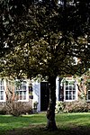 More images |
| Byron House | Highgate, Haringey | House | Early 18th century | 19 March 1951 | TQ2827187543 51°34′20″N 0°09′02″W / 51.572172°N 0.150505°W / 51.572172; -0.150505 (Byron House) | 1358887 |  More images |
| Church of St Bartholomew | Stamford Hill, Haringey | Parish Church | 1904 | 10 May 1974 | TQ3386688160 51°34′35″N 0°04′11″W / 51.576417°N 0.069586°W / 51.576417; -0.069586 (Church of St Bartholomew) | 1079264 |  More images |
| Church of St John the Baptist (greek Orthodox) | Harringay, Haringey | Parish Church | 1896–1898 | 10 May 1974 | TQ3119889208 51°35′11″N 0°06′28″W / 51.586462°N 0.107673°W / 51.586462; -0.107673 (Church of St John the Baptist (greek Orthodox)) | 1189472 | 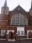 More images |
| Dial House | Tottenham, Haringey | House | Late 17th century | 22 July 1949 | TQ3390091350 51°36′18″N 0°04′04″W / 51.605075°N 0.067879°W / 51.605075; -0.067879 (Dial House) | 1079241 |  Upload Photo |
| Forecourt Walls and Railings to Number 796 (Percy House) | Tottenham, Haringey | Gate | LATE 17th century OR EARLY 18th century | 22 July 1949 | TQ3389291382 51°36′19″N 0°04′05″W / 51.605365°N 0.067982°W / 51.605365; -0.067982 (Forecourt Walls and Railings to Number 796 (Percy House)) | 1079243 | Upload Photo |
| Front Wall and Gates to the Priory | Tottenham, Haringey | Gate | Early 18th century | 10 May 1974 | TQ3333390788 51°36′01″N 0°04′35″W / 51.600159°N 0.076275°W / 51.600159; -0.076275 (Front Wall and Gates to the Priory) | 1358844 |  More images |
| Hornsey Town Hall | Crouch End, Haringey | Town Hall | 1935 | 16 January 1981 | TQ3020488316 51°34′43″N 0°07′20″W / 51.578676°N 0.122343°W / 51.578676; -0.122343 (Hornsey Town Hall) | 1263688 |  More images |
| Ireton House | Highgate, Haringey | House | 18th century | 19 March 1951 | TQ2878487300 51°34′12″N 0°08′36″W / 51.569872°N 0.143196°W / 51.569872; -0.143196 (Ireton House) | 1079235 |  More images |
| Ivy House and Northgate House | Highgate, Haringey | House | Post-1664 | 19 March 1951 | TQ2863987356 51°34′13″N 0°08′43″W / 51.570408°N 0.145267°W / 51.570408; -0.145267 (Ivy House and Northgate House) | 1358831 |  More images |
| Odeon Cinema | Muswell Hill, Haringey | Cinema | 1935–1936 | 6 March 1984 | TQ2850889490 51°35′23″N 0°08′47″W / 51.589615°N 0.146376°W / 51.589615; -0.146376 (Odeon Cinema) | 1079178 |  More images |
| Parish Church of All Hallows | Tottenham, Haringey | Parish Church | 14th century | 22 July 1949 | TQ3331590854 51°36′03″N 0°04′35″W / 51.600757°N 0.07651°W / 51.600757; -0.07651 (Parish Church of All Hallows) | 1188633 |  More images |
| Parish Church of St Ann | St Ann's, Haringey | Parish Church | 1861 | 10 May 1974 | TQ3282488674 51°34′53″N 0°05′04″W / 51.581283°N 0.084419°W / 51.581283; -0.084419 (Parish Church of St Ann) | 1358852 |  More images |
| Percy House | Tottenham, Haringey | House | Mid 18th century | 22 July 1949 | TQ3390491385 51°36′19″N 0°04′04″W / 51.605389°N 0.067808°W / 51.605389; -0.067808 (Percy House) | 1079242 | Upload Photo |
| The Queens Public House | Crouch End, Haringey | Hotel | 1899–1901 | 23 November 1973 | TQ3022888571 51°34′51″N 0°07′19″W / 51.580962°N 0.121902°W / 51.580962; -0.121902 (The Queens Public House) | 1079170 | 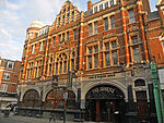 More images |
| The Salisbury Public House | Harringay, Haringey | Restaurant | 1898–1899 | 10 May 1974 | TQ3178888753 51°34′56″N 0°05′58″W / 51.582235°N 0.099333°W / 51.582235; -0.099333 (The Salisbury Public House) | 1358865 | 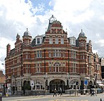 More images |
| The Sycamores | 17-21 North Road, Highgate, Haringey | House | Early 18th century | 19 March 1951 | TQ2828387560 51°34′20″N 0°09′01″W / 51.572322°N 0.150326°W / 51.572322; -0.150326 (The Sycamores) | 1079194 |  More images |
| Top Rank Club | Wood Green, Haringey | Bingo Hall | 1933–34 | 26 March 1990 | TQ3100090285 51°35′46″N 0°06′36″W / 51.596186°N 0.110128°W / 51.596186; -0.110128 (Top Rank Club) | 1263635 | Upload Photo |
| Tower of Old Parish Church of St Mary | Hornsey, Haringey | Tower | 15th century | 19 March 1951 | TQ3063189290 51°35′14″N 0°06′57″W / 51.58733°N 0.115822°W / 51.58733; -0.115822 (Tower of Old Parish Church of St Mary) | 1189047 | 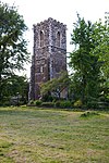 More images |
| No. 583 and 585 High Road | Tottenham, Haringey | House | Early to mid-18th century | 22 July 1949 | TQ3384590376 51°35′47″N 0°04′09″W / 51.596336°N 0.069044°W / 51.596336; -0.069044 (No. 583 and 585 High Road) | 1358855 | Upload Photo |
| No. 808 and 810 High Road | Tottenham, Haringey | House | Early 18th century | 22 July 1949 | TQ3390291452 51°36′22″N 0°04′04″W / 51.605991°N 0.067811°W / 51.605991; -0.067811 (No. 808 and 810 High Road) | 1358835 | Upload Photo |
Notes
- ^ a b The date given is the date used by Historic England as significant for the initial building or that of an important part in the structure's description.
- ^ a b Sometimes known as OSGB36, the grid reference is based on the British national grid reference system used by the Ordnance Survey.
- ^ a b The "List Entry Number" is a unique number assigned to each listed building and scheduled monument by Historic England.
External links
 Media related to Grade I listed buildings in the London Borough of Haringey at Wikimedia Commons
- Media related to Grade II* listed buildings in the London Borough of Haringey at Wikimedia Commons
- v
- t
- e


- Albert Road Recreation Ground
- Alexandra Park
- Bruce Castle Park
- Chestnuts Park
- Coldfall Wood
- Down Lane Park
- Downhills Park
- Ducketts Common
- Finsbury Park
- Highgate Wood
- Lordship Recreation Ground
- Markfield Park
- Parkland Walk
- Priory Park
- Queen's Wood
- Railway Fields
- Stationers Park
- Tottenham Marshes
- Woodside Park
- Hornsey and Wood Green
- Tottenham

- Coat of arms
- Council
- Grade I and II* listed buildings
- People
- Public art
- Schools
 Category
- Commons

Portals:
 London
 Architecture


