Grade I and II* listed buildings in the London Borough of Harrow
Map all coordinates using OpenStreetMap
Download coordinates as:
- KML
- GPX (all coordinates)
- GPX (primary coordinates)
- GPX (secondary coordinates)
There are over 9,000 Grade I listed buildings and 20,000 Grade II* listed buildings in England. This page is a list of these buildings in the London Borough of Harrow.
Grade I
| Name | Location | Type | Completed [note 1] | Date designated | Grid ref.[note 2] Geo-coordinates | Entry number [note 3] | Image |
|---|---|---|---|---|---|---|---|
| Church of St Lawrence | Little Stanmore, Harrow | Church | Early 16th century[a] | 21 September 1951 | TQ1855891329 51°36′30″N 0°17′22″W / 51.608322°N 0.289312°W / 51.608322; -0.289312 (Church of St Lawrence) | 1194471 | 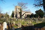 More images |
| Headstone Manor | Harrow | Hall House | Early 15th century | 21 September 1951 | TQ1409689705 51°35′41″N 0°21′15″W / 51.594647°N 0.354246°W / 51.594647; -0.354246 (Headstone Manor) | 1285855 | 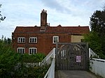 More images |
| Parish Church of St Mary | Harrow on the Hill, Harrow | Church | Norman | 21 September 1951 | TQ1531687452 51°34′27″N 0°20′15″W / 51.57415°N 0.33738°W / 51.57415; -0.33738 (Parish Church of St Mary) | 1079742 |  More images |
| The Old Schools, Harrow School | Harrow on the Hill, Harrow | School | 1615 | 21 September 1951 | TQ1531987361 51°34′24″N 0°20′15″W / 51.573332°N 0.337367°W / 51.573332; -0.337367 (The Old Schools, Harrow School) | 1079741 |  More images |
Grade II*
| Name | Location | Type | Completed [note 1] | Date designated | Grid ref.[note 2] Geo-coordinates | Entry number [note 3] | Image |
|---|---|---|---|---|---|---|---|
| Ace Cinema | Rayners Lane, Harrow | Cinema | 1936 | 13 March 1981 | TQ1301087371 51°34′26″N 0°22′14″W / 51.573889°N 0.370667°W / 51.573889; -0.370667 (Ace Cinema) | 1079729 |  More images |
| Barn South West of Headstone Manor | Headstone, Harrow | Barn | c. 1600 | 21 September 1951 | TQ1404189686 51°35′40″N 0°21′18″W / 51.594488°N 0.355045°W / 51.594488; -0.355045 (Barn South West of Headstone Manor) | 1358623 |  |
| Central Entrance Block to Bentley Priory | Stanmore, Harrow | House | 1789–90 | 25 May 1983 | TQ1547393279 51°37′35″N 0°20′00″W / 51.626488°N 0.333199°W / 51.626488; -0.333199 (Central Entrance Block to Bentley Priory) | 1358638 |  More images |
| Church of All Saints | Harrow Weald, Harrow | Church | 1842 | 24 February 1982 | TQ1533091725 51°36′45″N 0°20′09″W / 51.612551°N 0.335775°W / 51.612551; -0.335775 (Church of All Saints) | 1358649 | 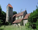 More images |
| Church of St John | Great Stanmore | Church | 1849 | 25 May 1983 | TQ1671992164 51°36′58″N 0°18′56″W / 51.616211°N 0.315578°W / 51.616211; -0.315578 (Church of St John) | 1193096 | 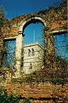 More images |
| Church of St John the Baptist | Pinner | Church | 13th century | 21 September 1951 | TQ1239089656 51°35′40″N 0°22′44″W / 51.59455°N 0.378879°W / 51.59455; -0.378879 (Church of St John the Baptist) | 1286312 |  More images |
| Church of St Mary | Kenton | Parish Hall | 1935-6 | 29 November 1993 | TQ1718488783 51°35′09″N 0°18′36″W / 51.585728°N 0.309994°W / 51.585728; -0.309994 (Church of St Mary) | 1254054 |  More images |
| East End Farm Cottage | Pinner | House | Early 15th century | 21 September 1951 | TQ1257689918 51°35′49″N 0°22′34″W / 51.596867°N 0.376111°W / 51.596867; -0.376111 (East End Farm Cottage) | 1358620 |  Upload Photo |
| Grim's Dyke | Harrow Weald, Harrow | House | 1872 | 5 September 1969 | TQ1417992883 51°37′23″N 0°21′07″W / 51.623193°N 0.352014°W / 51.623193; -0.352014 (Grim's Dyke) | 1079676 | 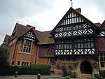 More images |
| Harrow School Chapel | Harrow on the Hill, Harrow | School | 1854–57 | 9 July 1968 | TQ1537487350 51°34′24″N 0°20′12″W / 51.573222°N 0.336577°W / 51.573222; -0.336577 (Harrow School Chapel) | 1079728 |  More images |
| Harrow Weald House Farm | Harrow Weald, Harrow | House | c. 1500 | 25 May 1983 | TQ1538991300 51°36′31″N 0°20′06″W / 51.608719°N 0.335063°W / 51.608719; -0.335063 (Harrow Weald House Farm) | 1286262 | Upload Photo |
| No. 73 Stanmore Hill | Stanmore, Harrow | House | Early 18th century | 21 September 1951 | TQ1669492626 51°37′13″N 0°18′57″W / 51.620368°N 0.315786°W / 51.620368; -0.315786 (No. 73 Stanmore Hill) | 1358643 | Upload Photo |
| Old Stanmore Church | Stanmore, Harrow | Church | 1632 | 21 September 1951 | TQ1664792157 51°36′58″N 0°19′00″W / 51.616163°N 0.31662°W / 51.616163; -0.31662 (Old Stanmore Church) | 1079747 |  More images |
| Pinner House | Pinner, Harrow | House | 17th century | 21 September 1951 | TQ1246289598 51°35′38″N 0°22′40″W / 51.594014°N 0.377859°W / 51.594014; -0.377859 (Pinner House) | 1358615 |  More images |
| Speech Room (Harrow School) | Harrow on the Hill, Harrow | School | 1872–1877 | 9 July 1968 | TQ1536887420 51°34′26″N 0°20′12″W / 51.573852°N 0.336641°W / 51.573852; -0.336641 (Speech Room (Harrow School)) | 1193321 |  More images |
| Stanmore Hall | Stanmore, Harrow | Town House | c. 1843 | 26 August 1971 | TQ1650993067 51°37′28″N 0°19′06″W / 51.62437°N 0.31831°W / 51.62437; -0.31831 (Stanmore Hall) | 1194606 |  More images |
| Sweetmans Hall | Pinner | House | Late C16 | 21 September 1951 | TQ1175689614 51°35′39″N 0°23′17″W / 51.594298°N 0.388041°W / 51.594298; -0.388041 (Sweetmans Hall) | 1194385 | Upload Photo |
| The White Cottage | Harrow on the Hill, Harrow | House | 1908 | 22 December 1982 | TQ1527686447 51°33′54″N 0°20′18″W / 51.565126°N 0.338287°W / 51.565126; -0.338287 (The White Cottage) | 1079652 |  |
| Vaughan Library (Harrow School) | Harrow on the Hill, Harrow | School | 1861-3 | 9 July 1968 | TQ1537487316 51°34′22″N 0°20′12″W / 51.572916°N 0.336588°W / 51.572916; -0.336588 (Vaughan Library (Harrow School)) | 1193423 |  More images |
| Harrow School War Memorial Building | Harrow on the Hill, Harrow | War memorial | 1926 | 9 July 1968 | TQ1535287365 51°34′24″N 0°20′13″W / 51.573361°N 0.33688954°W / 51.573361; -0.33688954 (Harrow School War Memorial Building) | 1358630 | 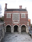 More images |
Notes
- ^ a b The date given is the date used by Historic England as significant for the initial building or that of an important part in the structure's description.
- ^ a b Sometimes known as OSGB36, the grid reference is based on the British national grid reference system used by the Ordnance Survey.
- ^ a b The "List Entry Number" is a unique number assigned to each listed building and scheduled monument by Historic England.
- ^ Heavily modified in the 18th century; the most interesting features of the building date to this period.
External links
 Media related to Grade I listed buildings in the London Borough of Harrow at Wikimedia Commons
- Media related to Grade II* listed buildings in the London Borough of Harrow at Wikimedia Commons
- v
- t
- e
| Partly in Brent |
|---|


- Harrow West
- Harrow East
- Ruislip, Northwood and Pinner

- Council
- Grade I and II* listed buildings
- People
- Public art
- Schools
 Category
- Commons

Portals:
 London
 Architecture


