Höhenland
Municipality in Brandenburg, Germany
Location of Höhenland within Märkisch-Oderland district

(2024–29) Karsten Eschner[1]
(2022-12-31)[2]
16259
Höhenland is a municipality in the district Märkisch-Oderland, in Brandenburg, Germany.
Demography

|
|
- Wölsickendorf
-
 Church
 -
 Manor house
 -
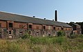
 Former Distillery
 -
 Barnyard
 -
 Traffic sign


References
- ^ Landkreis Märkisch-Oderland Wahl der Bürgermeisterin / des Bürgermeisters. Retrieved 3 July 2024.
- ^ "Bevölkerungsentwicklung und Bevölkerungsstandim Land Brandenburg Dezember 2022" (PDF). Amt für Statistik Berlin-Brandenburg (in German). June 2023.
- ^ Detailed data sources are to be found in the Wikimedia Commons.Population Projection Brandenburg at Wikimedia Commons
External links
![]() Media related to Höhenland at Wikimedia Commons
Media related to Höhenland at Wikimedia Commons
- v
- t
- e
Towns and municipalities in Märkisch-Oderland
- Alt Tucheband
- Altlandsberg
- Bad Freienwalde
- Beiersdorf-Freudenberg
- Bleyen-Genschmar
- Bliesdorf
- Buckow
- Falkenberg
- Falkenhagen
- Fichtenhöhe
- Fredersdorf-Vogelsdorf
- Garzau-Garzin
- Golzow
- Gusow-Platkow
- Heckelberg-Brunow
- Höhenland
- Hoppegarten
- Küstriner Vorland
- Lebus
- Letschin
- Lietzen
- Lindendorf
- Märkische Höhe
- Müncheberg
- Neuenhagen bei Berlin
- Neuhardenberg
- Neulewin
- Neutrebbin
- Oberbarnim
- Oderaue
- Petershagen-Eggersdorf
- Podelzig
- Prötzel
- Rehfelde
- Reichenow-Möglin
- Reitwein
- Rüdersdorf
- Seelow
- Strausberg
- Treplin
- Vierlinden
- Waldsieversdorf
- Wriezen
- Zechin
- Zeschdorf

| Authority control databases |
|
|---|
 | This Brandenburg location article is a stub. You can help Wikipedia by expanding it. |
- v
- t
- e


