Inchydoney
51°36′07″N 8°52′34″W / 51.602°N 8.876°W / 51.602; -8.876


Inchydoney
Location in Ireland
Ireland
Inchydoney or Inchydoney Island (from Irish Inse Duine)[1] (sometimes misspelled Inchadoney)[2] is a small island off West Cork, Ireland, connected to the mainland by two causeways. The nearest town is Clonakilty. It has a Blue Flag beach.[2]
It is a tourist destination with two beaches, one either side of the Virgin Mary headland. In summer there is a lifeguard station on the headland for three months.
History
The island was granted by Queen Elizabeth I to the Church of Ireland Bishop of Ross in 1584. During the Irish Confederate Wars, when a Protestant force led by Lord Forbes retook the town of Clonakilty from Catholic rebels in 1642, several hundred rebels fled towards the island to take refuge, but were caught and drowned in the rising tide before reaching Inchydoney.[3][4]
Gallery
-
 Rocky cove east of Inchdoney headland
 -
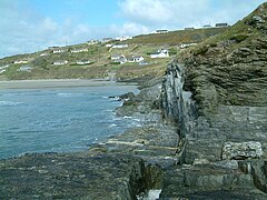
 Outcrops to west of Inchdoney
 -
 Inchydoney beach


References
- ^ "Oileán Inse Duine / Inchydoney Island". logainm.ie. Placenames Database of Ireland.
- ^ a b "Inchydoney, West Cork". Archived from the original on 3 September 2010.
- ^ Lewis, Samuel (1837). "Island". A Topographical Dictionary of Ireland. Lewis.
- ^ Lewis, Samuel (1837). "Clonkilty". A Topographical Dictionary of Ireland. Lewis. Archived from the original on 18 January 2021. Retrieved 12 September 2020.
![]() Media related to Inchydoney at Wikimedia Commons
Media related to Inchydoney at Wikimedia Commons
- v
- t
- e


