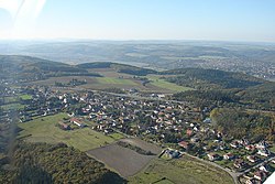
Jíloviště | |
|---|---|
 Aerial view | |
| Coordinates: 49°55′39″N 14°20′34″E / 49.92750°N 14.34278°E | |
| Country | |
| Region | Central Bohemian |
| District | Prague-West |
| First mentioned | 1347 |
| Area | |
• Total | 14.01 km2 (5.41 sq mi) |
| Elevation | 353 m (1,158 ft) |
| Population (2025-01-01)[1] | |
• Total | 712 |
| • Density | 51/km2 (130/sq mi) |
| Time zone | UTC+1 (CET) |
| • Summer (DST) | UTC+2 (CEST) |
| Postal code | 252 02 |
| Website | jiloviste |
Jíloviště is a municipality and village in Prague-West District in the Central Bohemian Region of the Czech Republic. It has about 700 inhabitants.
Etymology
[edit]The name is derived from the Czech word jíl (i.e. 'clay') and translates as 'clay pit'.[2]
Geography
[edit]Jíloviště is located about 12 kilometres (7 mi) southwest of Prague. It lies mostly in the Brdy Highlands, only the southern and western part of the municipal territory extends into the Benešov Uplands. The highest point is the Kámen hill at 414 m (1,358 ft) above sea level. The Vrané Reservoir, built on the Vltava River, is located east of the municipality just outside the municipal territory. The Vltava briefly crosses the eastern part of the municipal territory. The Berounka River briefly flows along the western municipal border, outside the territoy of Jíloviště.
History
[edit]The first written mention of Jíloviště is in a deed of Zbraslav Monastery from 1347. The village was founded after 1342. The monastery owned Jíloviště until 1420, when the Hussites burned down the monastery. In 1420, the village was acquired by a lower noblemen Zikmund Bolechovec of Pušperk, but between 1471 and 1526, it became a property of the Zbraslav Monastery again.[3]
In the mid-16th century, Jíloviště was described as abandoned, but it was repopulated in 1587 at the latest. Around 1639, during the Thirty Years' War, the village was burned down. The Zbraslav Monastery was abolished in 1785 and the estate was managed by the religious fund since then. In 1825, the Zbraslav estate was bought by Count Bedřich Jindřich Öettinger-Wallerstein. In 1848, Jíloviště became an independent municipality.[3]
Demographics
[edit]
|
|
| ||||||||||||||||||||||||||||||||||||||||||||||||||||||
| Source: Censuses[4][5] | ||||||||||||||||||||||||||||||||||||||||||||||||||||||||
Transport
[edit]The D4 motorway from Prague to Písek runs through the municipal territory.
Sights
[edit]
Among the protected cultural monuments in the municipality are two gords called Humenská and Kazín. Only terrain remains have survived. The localities are archaeological sites.[6]
A landmark in the centre of Jíloviště is the Chapel of Saint Florian. It was originally a firehouse, transformed into the chapel in 2014.[7]
References
[edit]- ^ "Population of Municipalities – 1 January 2025". Czech Statistical Office. 2025-05-16.
- ^ Profous, Antonín (1949). Místní jména v Čechách II: CH–L (in Czech). p. 152.
- ^ a b "Historie obce" (in Czech). Obec Jíloviště. Retrieved 2025-05-05.
- ^ "Historický lexikon obcí České republiky 1869–2011" (in Czech). Czech Statistical Office. 2015-12-21.
- ^ "Population Census 2021: Population by sex". Public Database. Czech Statistical Office. 2021-03-27.
- ^ "Výsledky vyhledávání: Kulturní památky, obec Jíloviště". Ústřední seznam kulturních památek (in Czech). National Heritage Institute. Retrieved 2025-05-05.
- ^ "Zvonice – zpravodaj obce Jíloviště 3/2014" (PDF) (in Czech). Obec Jíloviště. 2014. Retrieved 2025-05-05.
External links
[edit]


