Kumkan Peak
Mountain in British Columbia, Canada


Kumkan Peak
Location in British Columbia
Show map of British Columbia
Kumkan Peak
Kumkan Peak (Canada)
Show map of CanadaCoast Mountains
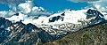
Kumkan Peak is a 2,742-metre (8,996-foot) mountain summit located in British Columbia, Canada.
Description
This remote glaciated peak is situated 31 km (19 mi) southwest of Lytton and is part of the Lillooet Ranges of the Coast Mountains. The nearest neighbor is Kwoiek Peak 2.35 km (1.46 mi) to the northwest and the nearest higher neighbor is Skihist Mountain, 12.82 km (8 mi) to the north.[1] Meltwater from the Kwoiek Glacier on the north slope drains into Kwoiek Creek, thence Fraser River, and precipitation runoff from the peak's south slope drains into headwaters of Mehatl Creek → Nahatlatch River → Fraser River. Topographic relief is significant as the summit rises 1,240 metres (4,068 ft) above Mehatl Creek in 2 km (1.2 mi). The first ascent of the summit was made August 16, 1958, by four members of the British Columbia Mountaineering Club: Dick Culbert, Art Dellow, Roy Mason, and Ralph Hutchinson.[4][5]
Etymology
The mountain's name is the traditional name for "head", presumably a reference to the peak's position at the head of the Kwoiek Creek watershed.[6] The toponym was officially adopted on April 3, 1950, by the Geographical Names Board of Canada.[6]
Climate
Based on the Köppen climate classification, Kumkan Peak is located in a subarctic climate zone of western North America.[7] Most weather fronts originate in the Pacific Ocean, and travel east toward the Coast Mountains where they are forced upward by the range (Orographic lift), causing them to drop their moisture in the form of rain or snowfall. As a result, the Coast Mountains experience high precipitation, especially during the winter months in the form of snowfall. Winter temperatures can drop below −20 °C with wind chill factors below −30 °C. This climate supports the Kwoiek Glacier on the north slope of the peak. The months July through September offer the most favorable weather for climbing Kumkan Peak.
See also
- Geography of British Columbia
 Mountains portal
- Haynon Peak

Gallery
-
 Aerial view of Kumkan Peak, Kwoiek Glacier and Stukolait Lake.
 -
 Aerial view of north aspect of Kumkan Peak (left) and Kwoiek Peak (right)


References
- ^ a b c d "Kumkan Peak, British Columbia". Peakbagger.com. Retrieved 2023-03-17.
- ^ a b "Kumkan Peak, Peakvisor.com". Retrieved 2023-03-17.
- ^ a b "Kumkan Peak". Geographical Names Data Base. Natural Resources Canada. Retrieved 2023-03-17.
- ^ The Canadian Alpine Journal (1959), Alpine Club of Canada, p. 36.
- ^ Dick Culbert (1974), Alpine Guide to Southwestern British Columbia, p. 171
- ^ a b "Kumkan Peak". BC Geographical Names.
- ^ Peel, M. C.; Finlayson, B. L.; McMahon, T. A. (2007). "Updated world map of the Köppen−Geiger climate classification". Hydrol. Earth Syst. Sci. 11. ISSN 1027-5606.
External links
- Weather: Kumkan Peak
- v
- t
- e
- Bendor
- Britannia
- Bunster
- Cadwallader
- Calliope
- Camelsfoot
- Cantilever
- Caren
- Cayley
- Chilcotin
- Colville
- Conical
- Douglas
- Earle
- Edwards
- Fannin
- Fitzsimmons
- Franklyn
- Fraser
- Garibaldi
- Gastineau
- Georgina
- Koeye
- Lewis
- Lillooet
- Meager
- Namu
- Nicholl
- Niut
- North Shore
- Pantheon
- Pembroke
- Sir Harry
- Tantalus
- Tottenham
- Unwin
- Waddington
- Wharncliffe
- Whitemantle
- Akasik
- Alfred
- Alice
- Arthur
- Asperity
- Birkenhead
- Bishop
- The Black Tusk
- Blackcomb
- Blanshard
- Brandywine
- Breakenridge
- Brew
- Brew
- Burke
- Callaghan
- Capricorn
- Castle Towers
- Cauldron
- Cayley
- Cinder Cone
- Clarke
- Coquitlam
- Crevasse Crag
- Crickmer
- Crown
- Currie
- Cypress
- Devastator
- Dewdney
- Eagle
- Edge
- Elsay
- Fang
- Fee
- Fitzgerald
- Forefinger
- Frederick William
- Fromme
- Garibaldi
- Good Hope
- Grouse
- Helena
- Job
- Judge Howay
- ḵ’els
- Kinch
- Little Finger
- Little Ring
- Luna
- Mamquam
- Meager
- Merlon
- Middle Finger
- Monarch
- Monmouth
- Munday
- Nicomen
- One Eye
- Opal Cone
- Overill
- Pali
- Petlushkwohap
- Plinth
- Powder
- Price
- Pylon
- Pyroclastic
- Queen Bess
- Raleigh
- Red Tusk
- Ring
- Robie Reid
- Round
- Serratus
- Seymour
- Silverthrone
- Skihist
- Stein
- Somolenko
- Spearhead
- Table
- Tantalus
- Taseko
- Tatlow
- Tiedemann
- Tricouni
- Tuber
- Vic
- Vulcan's Thumb
- Waddington
- Wedge
- Wellington
- ʔEniyud (Niut)
- Clendinning
- Duffey Lake
- Garibaldi
- Mount Elphinstone
- Stein Valley Nlaka'pamux Heritage
- Spruce Lake (South Chilcotin)
- Upper Lillooet
- Golden Ears
- Tantalus
- Mehatl Creek
- Birkenhead Lake
- Joffre Lakes
- Ts'il?os
- Bishop River
- Princess Louisa Marine
- Callaghan
- Nairn Falls
- Brandywine Falls
- Alice Lake
- Blackcomb Glacier
- Tetrahedron
- Stawamus Chief
- Murrin
- Mount Seymour
- Cypress
- Say Nuth Khaw Yum (Indian Arm)
- Pinecone-Burke
- Shannon Falls
- Rolley Lake
- Sasquatch
- Big Creek
- Homathko Estuary
- Davis Lake


