List of listed buildings in Carnock, Fife
This is a list of listed buildings in the parish of Carnock in Fife, Scotland.
Map all coordinates using OpenStreetMap
Download coordinates as:
- KML
- GPX (all coordinates)
- GPX (primary coordinates)
- GPX (secondary coordinates)
List
| Name | Location | Date Listed | Grid Ref. [note 1] | Geo-coordinates | Notes | LB Number [note 2] | Image |
|---|---|---|---|---|---|---|---|
| Gowkhall, Luscar House And Stables | 56°05′20″N 3°31′27″W / 56.088944°N 3.524205°W / 56.088944; -3.524205 (Gowkhall, Luscar House And Stables) | Category B | 43646 |  Upload Photo | |||
| 45 Station Road Oakley | 56°05′02″N 3°34′04″W / 56.083814°N 3.567891°W / 56.083814; -3.567891 (45 Station Road Oakley) | Category B | 3432 | Upload Photo | |||
| Blair House | 56°05′23″N 3°33′57″W / 56.089769°N 3.565963°W / 56.089769; -3.565963 (Blair House) | Category B | 3420 | Upload Photo | |||
| Pitdinnie Dovecot South Pitdinnie Farm | 56°03′57″N 3°31′58″W / 56.065799°N 3.532672°W / 56.065799; -3.532672 (Pitdinnie Dovecot South Pitdinnie Farm) | Category B | 3430 | Upload Photo | |||
| Cairneyhill Church Of Scotland Main Street Cairneyhill | 56°03′39″N 3°31′31″W / 56.060795°N 3.525391°W / 56.060795; -3.525391 (Cairneyhill Church Of Scotland Main Street Cairneyhill) | Category B | 3431 | Upload Photo | |||
| Easter Luscar House | 56°05′32″N 3°31′26″W / 56.092217°N 3.523997°W / 56.092217; -3.523997 (Easter Luscar House) | Category C(S) | 3419 | Upload Photo | |||
| Carnock Parish Manse Main Street Carnock | 56°05′07″N 3°32′31″W / 56.0854°N 3.54184°W / 56.0854; -3.54184 (Carnock Parish Manse Main Street Carnock) | Category C(S) | 3410 | Upload Photo | |||
| Blair Tower Blair Tower Wood | 56°05′21″N 3°33′34″W / 56.089213°N 3.559479°W / 56.089213; -3.559479 (Blair Tower Blair Tower Wood) | Category B | 3421 | 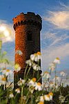 Upload another image | |||
| Newbigging Farmhouse | 56°05′20″N 3°32′14″W / 56.088811°N 3.537106°W / 56.088811; -3.537106 (Newbigging Farmhouse) | Category C(S) | 3433 | Upload Photo | |||
| Carnock Old Parish Kirk Carnock Burial Ground | 56°05′07″N 3°32′32″W / 56.08526°N 3.542236°W / 56.08526; -3.542236 (Carnock Old Parish Kirk Carnock Burial Ground) | Category B | 3411 | Upload Photo | |||
| Sepulchral Monument And Burial Enclosure Carnock Burial Ground | 56°05′07″N 3°32′32″W / 56.085368°N 3.542256°W / 56.085368; -3.542256 (Sepulchral Monument And Burial Enclosure Carnock Burial Ground) | Category B | 3412 | Upload Photo | |||
| Oakley, Station Road, Church Of The Most Holy Name | 56°04′47″N 3°34′06″W / 56.079603°N 3.568298°W / 56.079603; -3.568298 (Oakley, Station Road, Church Of The Most Holy Name) | Category B | 45593 | Upload Photo | |||
| Carnock Parish Kirk Main Street Carnock | 56°05′04″N 3°32′24″W / 56.084542°N 3.540006°W / 56.084542; -3.540006 (Carnock Parish Kirk Main Street Carnock) | Category B | 3409 | Upload Photo | |||
| The Old Inn 6 Main Street Carnock | 56°05′03″N 3°32′22″W / 56.084063°N 3.539521°W / 56.084063; -3.539521 (The Old Inn 6 Main Street Carnock) | Category C(S) | 3413 | Upload Photo | |||
| Carnock Village Carnock House Garden Walls And Gatepiers | 56°05′10″N 3°32′43″W / 56.086084°N 3.545339°W / 56.086084; -3.545339 (Carnock Village Carnock House Garden Walls And Gatepiers) | Category B | 3429 | Upload Photo |
Key
The scheme for classifying buildings in Scotland is:
- Category A: "buildings of national or international importance, either architectural or historic; or fine, little-altered examples of some particular period, style or building type."[1]
- Category B: "buildings of regional or more than local importance; or major examples of some particular period, style or building type, which may have been altered."[1]
- Category C: "buildings of local importance; lesser examples of any period, style, or building type, as originally constructed or moderately altered; and simple traditional buildings which group well with other listed buildings."[1]
In March 2016 there were 47,288 listed buildings in Scotland. Of these, 8% were Category A, and 50% were Category B, with the remaining 42% being Category C.[2]
See also
Notes
- ^ Sometimes known as OSGB36, the grid reference (where provided) is based on the British national grid reference system used by the Ordnance Survey.
• "Guide to National Grid". Ordnance Survey. Retrieved 12 December 2007.
• "Get-a-map". Ordnance Survey. Retrieved 17 December 2007. - ^ Historic Environment Scotland assign a unique alphanumeric identifier to each designated site in Scotland, for listed buildings this always begins with "LB", for example "LB12345".
References
- All entries, addresses and coordinates are based on data from Historic Scotland. This data falls under the Open Government Licence
- ^ a b c "What is Listing?". Historic Environment Scotland. Retrieved 29 May 2018.
- ^ Scotland's Historic Environment Audit 2016 (PDF). Historic Environment Scotland and the Built Environment Forum Scotland. pp. 15–16. Retrieved 29 May 2018.


