List of listed buildings in Northmavine, Shetland Islands
This is a list of listed buildings in the parish of Northmavine in the Shetland Islands, Scotland.
Map all coordinates using OpenStreetMap
Download coordinates as:
- KML
- GPX (all coordinates)
- GPX (primary coordinates)
- GPX (secondary coordinates)
List
| Name | Location | Date Listed | Grid Ref. [note 1] | Geo-coordinates | Notes | LB Number [note 2] | Image |
|---|---|---|---|---|---|---|---|
| North Roe Post Office | 60°34′44″N 1°19′57″W / 60.578928°N 1.33245°W / 60.578928; -1.33245 (North Roe Post Office) | Category C(S) | 44560 |  Upload another image | |||
| Hillswick, Northmavine Kirk, Including Kirkyard Wall, Gate, And Gatepiers | 60°28′37″N 1°29′13″W / 60.476843°N 1.487004°W / 60.476843; -1.487004 (Hillswick, Northmavine Kirk, Including Kirkyard Wall, Gate, And Gatepiers) | Category B | 19900 | 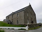 Upload another image | |||
| Ollaberry, Ollaberry Kirkyard Monument | 60°30′25″N 1°20′02″W / 60.506981°N 1.33393°W / 60.506981; -1.33393 (Ollaberry, Ollaberry Kirkyard Monument) | Category B | 18687 |  Upload Photo | |||
| Hillswick, Hillswick House, Including Gatepiers, Outbuildings, Cottage, Garden And Boundary Walls | 60°28′34″N 1°29′19″W / 60.476095°N 1.488543°W / 60.476095; -1.488543 (Hillswick, Hillswick House, Including Gatepiers, Outbuildings, Cottage, Garden And Boundary Walls) | Category B | 18688 | Upload Photo | |||
| Ollaberry, Ollaberry Bods, Including Retaining Wall And Steps | 60°30′25″N 1°20′08″W / 60.506845°N 1.335426°W / 60.506845; -1.335426 (Ollaberry, Ollaberry Bods, Including Retaining Wall And Steps) | Category C(S) | 44563 | Upload Photo | |||
| North Roe Methodist Church, Including Railings | 60°34′46″N 1°19′58″W / 60.579531°N 1.332748°W / 60.579531; -1.332748 (North Roe Methodist Church, Including Railings) | Category C(S) | 44558 | 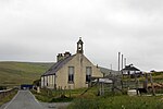 Upload another image | |||
| North Roe, Telephone Kiosk | 60°34′44″N 1°19′57″W / 60.578991°N 1.332394°W / 60.578991; -1.332394 (North Roe, Telephone Kiosk) | Category B | 44561 | Upload another image | |||
| Ollaberry, Bardister Haa, With Outbuilding And Garden Walls | 60°28′45″N 1°20′51″W / 60.479242°N 1.347633°W / 60.479242; -1.347633 (Ollaberry, Bardister Haa, With Outbuilding And Garden Walls) | Category B | 44562 | Upload Photo | |||
| Hamnavoe, Johnny 'Notion' Williamson's House, Including Outbuildings | 60°30′30″N 1°34′11″W / 60.508291°N 1.569827°W / 60.508291; -1.569827 (Hamnavoe, Johnny 'Notion' Williamson's House, Including Outbuildings) | Category C(S) | 18692 | 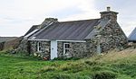 Upload another image | |||
| North Roe, North Haa, Including Walls And Outbuildings | 60°35′09″N 1°19′55″W / 60.585705°N 1.332055°W / 60.585705; -1.332055 (North Roe, North Haa, Including Walls And Outbuildings) | Category C(S) | 44559 | Upload Photo | |||
| Hillswick, St Magnus Bay Hotel | 60°28′36″N 1°29′17″W / 60.476802°N 1.488078°W / 60.476802; -1.488078 (Hillswick, St Magnus Bay Hotel) | Category C(S) | 18689 | 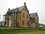 Upload another image | |||
| Tangwick, Haa Of Tangwick, Including Walled Garden | 60°28′56″N 1°34′44″W / 60.48221°N 1.57896°W / 60.48221; -1.57896 (Tangwick, Haa Of Tangwick, Including Walled Garden) | Category B | 18690 | 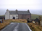 Upload another image | |||
| Eshaness, Eshaness Lighthouse, Including Oil Tank, Sundial, And Gates | 60°29′21″N 1°37′38″W / 60.489223°N 1.627329°W / 60.489223; -1.627329 (Eshaness, Eshaness Lighthouse, Including Oil Tank, Sundial, And Gates) | Category B | 44556 | 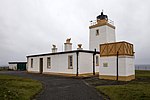 Upload another image | |||
| North Roe, Lochend House, Including Outbuilding And Garden Wall | 60°32′25″N 1°19′49″W / 60.540219°N 1.330185°W / 60.540219; -1.330185 (North Roe, Lochend House, Including Outbuilding And Garden Wall) | Category C(S) | 44557 | Upload Photo | |||
| Stenness, Stenness Fishing Station Bod | 60°28′38″N 1°36′42″W / 60.477228°N 1.611731°W / 60.477228; -1.611731 (Stenness, Stenness Fishing Station Bod) | Category C(S) | 44565 | 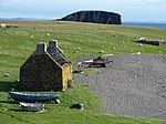 Upload another image | |||
| Ollaberry, Ollaberry Pier, Including Derrick And Walls | 60°30′23″N 1°20′09″W / 60.50646°N 1.335707°W / 60.50646; -1.335707 (Ollaberry, Ollaberry Pier, Including Derrick And Walls) | Category B | 44564 |  Upload another image | |||
| Hillswick, Northmavine Manse, Including Garden And Boundary Walls And Outbuildings | 60°28′26″N 1°29′24″W / 60.473811°N 1.490016°W / 60.473811; -1.490016 (Hillswick, Northmavine Manse, Including Garden And Boundary Walls And Outbuildings) | Category B | 18686 | 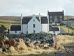 Upload another image | |||
| Ollaberry, Ollaberry House (Haa Of Ollaberry), Including Outbuilding And Boundary Walls | 60°30′25″N 1°20′10″W / 60.50684°N 1.336172°W / 60.50684; -1.336172 (Ollaberry, Ollaberry House (Haa Of Ollaberry), Including Outbuilding And Boundary Walls) | Category B | 18691 | Upload Photo |
Key
The scheme for classifying buildings in Scotland is:
- Category A: "buildings of national or international importance, either architectural or historic; or fine, little-altered examples of some particular period, style or building type."[1]
- Category B: "buildings of regional or more than local importance; or major examples of some particular period, style or building type, which may have been altered."[1]
- Category C: "buildings of local importance; lesser examples of any period, style, or building type, as originally constructed or moderately altered; and simple traditional buildings which group well with other listed buildings."[1]
In March 2016 there were 47,288 listed buildings in Scotland. Of these, 8% were Category A, and 50% were Category B, with the remaining 42% being Category C.[2]
Notes
- ^ Sometimes known as OSGB36, the grid reference (where provided) is based on the British national grid reference system used by the Ordnance Survey.
• "Guide to National Grid". Ordnance Survey. Retrieved 12 December 2007.
• "Get-a-map". Ordnance Survey. Retrieved 17 December 2007. - ^ Historic Environment Scotland assign a unique alphanumeric identifier to each designated site in Scotland, for listed buildings this always begins with "LB", for example "LB12345".
References
- All entries, addresses and coordinates are based on data from Historic Scotland. This data falls under the Open Government Licence
- ^ a b c "What is Listing?". Historic Environment Scotland. Retrieved 29 May 2018.
- ^ Scotland's Historic Environment Audit 2016 (PDF). Historic Environment Scotland and the Built Environment Forum Scotland. pp. 15–16. Retrieved 29 May 2018.


