Mesa Falls Tuff
Volcanic formation in Idaho, United States
44°20′N 111°20′W / 44.33°N 111.33°W / 44.33; -111.33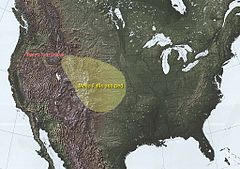
Extent of the Mesa Falls ash bed
The Mesa Falls Tuff is a tuff formation produced by the Mesa Falls eruption that formed the Henry's Fork Caldera that is located in Idaho west of Yellowstone National Park.[1] It is the second most recent caldera forming eruption from the Yellowstone hotspot and ejected of 280 km3 (67 cu mi) of material. This eruption, 1.3 million years BP, was preceded by the Huckleberry Ridge Tuff and succeeded by the Lava Creek Tuff, both of which were also formed by the Yellowstone hotspot.[2]
See also
- Yellowstone Caldera
- Snake River Plain
- Island Park, Idaho
- Upper Mesa Falls
- Lower Mesa Falls
References
- v
- t
- e
State of Idaho
Boise (capital)
- Index
- Geography
- Government
- Delegations
- Governors
- History
- Images
- People
- Symbols
- Tourist attractions
cities
cities
- Ada
- Adams
- Bannock
- Bear Lake
- Benewah
- Bingham
- Blaine
- Boise
- Bonner
- Bonneville
- Boundary
- Butte
- Camas
- Canyon
- Caribou
- Cassia
- Clark
- Clearwater
- Custer
- Elmore
- Franklin
- Fremont
- Gem
- Gooding
- Idaho
- Jefferson
- Jerome
- Kootenai
- Latah
- Lemhi
- Lewis
- Lincoln
- Madison
- Minidoka
- Nez Perce
- Oneida
- Owyhee
- Payette
- Power
- Shoshone
- Teton
- Twin Falls
- Valley
- Washington
 Idaho portal
| |||||||||||||
|---|---|---|---|---|---|---|---|---|---|---|---|---|---|
| Cenozoic Era (present–66.0 Ma) |
| ||||||||||||
| Mesozoic Era (66.0–252 Ma) |
| ||||||||||||
| Paleozoic Era (252–539 Ma) |
| ||||||||||||
| Proterozoic Eon (539 Ma–2.5 Ga) |
| ||||||||||||
| Archean Eon (2.5–4 Ga) | |||||||||||||
| Hadean Eon (4–4.6 Ga) | |||||||||||||
ka = kiloannum (thousands years ago); Ma = megaannum (millions years ago); Ga = gigaannum (billions years ago). See also: Geologic time scale •  Geology portal • Geology portal •  World portal World portal | |||||||||||||
 | This volcanology article is a stub. You can help Wikipedia by expanding it. |
- v
- t
- e
 | This article about a specific stratigraphic formation in Wyoming is a stub. You can help Wikipedia by expanding it. |
- v
- t
- e


