National Register of Historic Places listings in Cumberland Island National Seashore
This is a list of the National Register of Historic Places listings in Cumberland Island National Seashore.
This is intended to be a complete list of the properties and districts on the National Register of Historic Places in Cumberland Island National Seashore, Georgia, United States. The locations of National Register properties and districts for which the latitude and longitude coordinates are included below, may be seen in a Google map.[1]
There are eight properties and districts listed on the National Register in the park.
This National Park Service list is complete through NPS recent listings posted September 5, 2024.[2]
Map all coordinates using OpenStreetMap
Download coordinates as:
- KML
- GPX (all coordinates)
- GPX (primary coordinates)
- GPX (secondary coordinates)
Current listings
| [3] | Name on the Register | Image | Date listed[4] | Location | City or town | Description |
|---|---|---|---|---|---|---|
| 1 | Duck House | Upload image | February 13, 1984 (#84000938) | Cumberland Island 30°50′50″N 81°25′51″W / 30.847222°N 81.430833°W / 30.847222; -81.430833 (Duck House) | St. Marys | |
| 2 | Dungeness Historic District |  | February 13, 1984 (#84000920) | Address Restricted | St. Marys | |
| 3 | High Point-Half Moon Bluff Historic District | Upload image | December 22, 1978 (#78000265) | NE of St. Marys on Cumberland Island 30°55′14″N 81°25′56″W / 30.920556°N 81.432222°W / 30.920556; -81.432222 (High Point-Half Moon Bluff Historic District) | St. Marys | |
| 4 | Main Road | Upload image | February 13, 1984 (#84000938) | Cumberland Island 30°49′45″N 81°27′26″W / 30.829167°N 81.457222°W / 30.829167; -81.457222 (Main Road) | St. Marys | |
| 5 | Plum Orchard Historic District |  | November 23, 1984 (#84000258) | Address Restricted | St. Marys | |
| 6 | Rayfield Archeological District | Upload image | February 13, 1984 (#84000924) | Address Restricted | St. Marys | |
| 7 | Stafford Plantation Historic District |  | November 23, 1984 (#84000265) | Address Restricted | St. Marys | |
| 8 | Table Point Archeological District | Upload image | November 23, 1984 (#84000260) | Address Restricted | St. Marys |
Associated site
Greyfield is a private inholding on Cumberland Island.
| [3] | Name on the Register | Image | Date listed[4] | Location | City or town | Description |
|---|---|---|---|---|---|---|
| 1 | Greyfield | 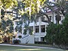 | July 24, 2003 (#03000675) | Cumberland Island 30°46′51″N 81°27′51″W / 30.780833°N 81.464167°W / 30.780833; -81.464167 (Greyfield) | Camden |
See also
- National Register of Historic Places listings in Camden County, Georgia
- National Register of Historic Places listings in Georgia
References
- ^ The latitude and longitude information provided in this table was derived originally from the National Register Information System, which has been found to be fairly accurate for about 99% of listings. Some locations in this table may have been corrected to current GPS standards.
- ^ National Park Service, United States Department of the Interior, "National Register of Historic Places: Weekly List Actions", retrieved September 5, 2024.
- ^ a b Numbers represent an alphabetical ordering by significant words. Various colorings, defined here, differentiate National Historic Landmarks and historic districts from other NRHP buildings, structures, sites or objects.
- ^ a b The eight-digit number below each date is the number assigned to each location in the National Register Information System database, which can be viewed by clicking the number.
Wikimedia Commons has media related to National Register of Historic Places in Cumberland Island National Seashore.
- v
- t
- e
- Dungeness Historic District
- High Point-Half Moon Bluff Historic District
- Plum Orchard Historic District
- Rayfield Archeological District
- Stafford Plantation Historic District
- Table Point Archeological District
- Duck House
- Main Road
See also: National Register of Historic Places listings in Cumberland Island National Seashore
| |
|---|---|
| Topics | |
| Lists by state |
|
| Lists by insular areas | |
| Lists by associated state | |
| Other areas | |
| Related | |
| |


