National Register of Historic Places listings in Prowers County, Colorado
List of National Register of Historic Places in Prowers County, Colorado, United States

This is a list of the National Register of Historic Places listings in Prowers County, Colorado.
This is intended to be a complete list of the properties and districts on the National Register of Historic Places in Prowers County, Colorado, United States. The locations of National Register properties and districts for which the latitude and longitude coordinates are included below, may be seen in a map.[1]
There are 16 properties and districts listed on the National Register in the county, including 1 National Historic Landmark.
This National Park Service list is complete through NPS recent listings posted September 5, 2024.[2]
- v
- t
- e
Properties on the National Register of Historic Places in Colorado by county
- Adams
- Alamosa
- Arapahoe
- Archuleta
- Baca
- Bent
- Boulder
- Broomfield
- Chaffee
- Cheyenne
- Clear Creek
- Conejos
- Costilla
- Crowley
- Custer
- Delta
- Denver
- Dolores
- Douglas
- Eagle
- El Paso
- Elbert
- Fremont
- Garfield
- Gilpin
- Grand
- Gunnison
- Hinsdale
- Huerfano
- Jackson
- Jefferson
- Kiowa
- Kit Carson
- La Plata
- Lake
- Larimer
- Las Animas
- Lincoln
- Logan
- Mesa
- Mineral
- Moffat
- Montezuma
- Montrose
- Morgan
- Otero
- Ouray
- Park
- Phillips
- Pitkin
- Prowers
- Pueblo
- Rio Blanco
- Rio Grande
- Routt
- Saguache
- San Juan
- San Miguel
- Sedgwick
- Summit
- Teller
- Washington
- Weld
- Yuma

Map all coordinates using OpenStreetMap
Download coordinates as:
- KML
- GPX (all coordinates)
- GPX (primary coordinates)
- GPX (secondary coordinates)
Current listings
| [3] | Name on the Register[4] | Image | Date listed[5] | Location | City or town | Description |
|---|---|---|---|---|---|---|
| 1 | Atchison, Topeka and Santa Fe Railway Passenger Depot | 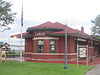 | July 19, 2019 (#100004186) | 109 E. Beech St. 38°05′23″N 102°37′05″W / 38.0896°N 102.6180°W / 38.0896; -102.6180 (Atchison, Topeka and Santa Fe Railway Passenger Depot) | Lamar | |
| 2 | Davies Hotel | 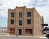 | October 19, 1978 (#78000875) | 122 N. Main 38°05′27″N 102°37′08″W / 38.090833°N 102.618889°W / 38.090833; -102.618889 (Davies Hotel) | Lamar | |
| 3 | Douglas Crossing Bridge | 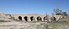 | February 4, 1985 (#85000224) | County Road 28 37°47′43″N 102°15′20″W / 37.795278°N 102.255556°W / 37.795278; -102.255556 (Douglas Crossing Bridge) | Granada | |
| 4 | Granada Bridge |  | October 15, 2002 (#02001138) | U.S. Route 385 at milepost 97.32 38°05′38″N 102°18′37″W / 38.093889°N 102.310278°W / 38.093889; -102.310278 (Granada Bridge) | Granada | |
| 5 | Granada Relocation Center | 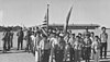 | May 18, 1994 (#94000425) | 23900 County Road FF, approximately 1 mile southwest of Granada 38°02′58″N 102°19′43″W / 38.049444°N 102.328611°W / 38.049444; -102.328611 (Granada Relocation Center) | Granada | |
| 6 | Holly City Hall |  | October 10, 2003 (#03001010) | 119 E. Cheyenne St. 38°03′07″N 102°07′17″W / 38.051944°N 102.121389°W / 38.051944; -102.121389 (Holly City Hall) | Holly | |
| 7 | Holly Gymnasium |  | April 24, 2007 (#07000344) | N. Main St. 38°03′18″N 102°07′19″W / 38.055°N 102.121944°W / 38.055; -102.121944 (Holly Gymnasium) | Holly | |
| 8 | Holly Santa Fe Depot | 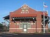 | July 28, 1995 (#95000935) | 302 S. Main St. 38°03′01″N 102°07′24″W / 38.050278°N 102.123333°W / 38.050278; -102.123333 (Holly Santa Fe Depot) | Holly | |
| 9 | Holly SS Ranch Barn |  | February 25, 2004 (#04000068) | 407 West Vinson 38°02′56″N 102°07′22″W / 38.048889°N 102.122778°W / 38.048889; -102.122778 (Holly SS Ranch Barn) | Holly | |
| 10 | Paulsen Farm | 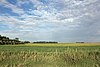 | December 9, 1999 (#99001542) | 39035 Road 7 38°12′28″N 102°37′54″W / 38.207778°N 102.631667°W / 38.207778; -102.631667 (Paulsen Farm) | Lamar | |
| 11 | Petticrew Stage Stop | Upload image | August 24, 2000 (#00000936) | About 25 miles (40 km) south of Lamar on the Cedar Cliff Ranch[6] Coordinates missing | Lamar | |
| 12 | Prowers County Building |  | September 21, 1981 (#81000186) | 301 S. Main St. 38°05′12″N 102°37′07″W / 38.08675°N 102.618611°W / 38.08675; -102.618611 (Prowers County Building) | Lamar | |
| 13 | Prowers County Welfare Housing |  | December 22, 2009 (#09001121) | 800 E. Maple St. 38°05′33″N 102°36′38″W / 38.092622°N 102.610567°W / 38.092622; -102.610567 (Prowers County Welfare Housing) | Lamar | |
| 14 | US Post Office-Lamar Main |  | January 22, 1986 (#86000179) | 300 S. 5th St. 38°05′12″N 102°37′19″W / 38.086667°N 102.621944°W / 38.086667; -102.621944 (US Post Office-Lamar Main) | Lamar | |
| 15 | Wiley Rock Schoolhouse | 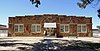 | February 20, 2004 (#04000057) | 603 Main St. 38°09′24″N 102°43′11″W / 38.156667°N 102.719722°W / 38.156667; -102.719722 (Wiley Rock Schoolhouse) | Wiley | |
| 16 | Willow Creek Park |  | August 7, 2007 (#07000789) | Roughly bounded by Memorial Dr., Parkview Ave., and Willow Valley Rd. 38°04′28″N 102°36′51″W / 38.074331°N 102.614256°W / 38.074331; -102.614256 (Willow Creek Park) | Lamar |
See also
 History portal
 United States portal
 Colorado portal
 National Register of Historic Places portal


- List of National Historic Landmarks in Colorado
- List of National Register of Historic Places in Colorado
- Bibliography of Colorado
- Geography of Colorado
- History of Colorado
- Index of Colorado-related articles
- List of Colorado-related lists
- Outline of Colorado
References
- ^ The latitude and longitude information provided in this table was derived originally from the National Register Information System, which has been found to be fairly accurate for about 99% of listings. Some locations in this table may have been corrected to current GPS standards.
- ^ National Park Service, United States Department of the Interior, "National Register of Historic Places: Weekly List Actions", retrieved September 5, 2024.
- ^ Numbers represent an alphabetical ordering by significant words. Various colorings, defined here, differentiate National Historic Landmarks and historic districts from other NRHP buildings, structures, sites or objects.
- ^ "National Register Information System". National Register of Historic Places. National Park Service. July 9, 2010.
- ^ The eight-digit number below each date is the number assigned to each location in the National Register Information System database, which can be viewed by clicking the number.
- ^ "Petticrew Stage Stop". 21 May 2018.
External links
Wikimedia Commons has media related to Prowers County, Colorado.
- State of Colorado
- History Colorado
- Prowers County, Colorado
| |
|---|---|
| Topics | |
| Lists by state |
|
| Lists by insular areas | |
| Lists by associated state | |
| Other areas | |
| Related | |
| |


Municipalities and communities of Prowers County, Colorado, United States | ||
|---|---|---|
County seat: Lamar | ||
| City |  | |
| Towns | ||
| Unincorporated communities | ||
| Former communities | ||
| ||
| |
|---|---|
Denver (capital) | |
| Topics |
|
| Society | |
| Cities |
|
| Counties |
|
| Regions |
|
 Colorado portal Colorado portal | |
37°57′18″N 102°23′36″W / 37.9549°N 102.3934°W / 37.9549; -102.3934 (Prowers County, Colorado)


