National Register of Historic Places listings in Stone County, Arkansas

This is a list of the National Register of Historic Places listings in Stone County, Arkansas.
This is intended to be a complete list of the properties and districts on the National Register of Historic Places in Stone County, Arkansas, United States. The locations of National Register properties and districts for which the latitude and longitude coordinates are included below, may be seen in a map.[1]
There are 57 properties and districts listed on the National Register in the county.
This National Park Service list is complete through NPS recent listings posted September 5, 2024.[2]
Map all coordinates using OpenStreetMap
Download coordinates as:
- KML
- GPX (all coordinates)
- GPX (primary coordinates)
- GPX (secondary coordinates)
Current listings
| [3] | Name on the Register[4] | Image | Date listed[5] | Location | City or town | Description |
|---|---|---|---|---|---|---|
| 1 | Jessie Abernathy House |  | September 17, 1985 (#85002216) | Off Highway 14 35°47′16″N 91°52′55″W / 35.787778°N 91.881944°W / 35.787778; -91.881944 (Jessie Abernathy House) | Marcella | |
| 2 | Alco School |  | September 4, 1992 (#92001125) | Just north of Highway 66 35°53′28″N 92°22′21″W / 35.891111°N 92.3725°W / 35.891111; -92.3725 (Alco School) | Alco | |
| 3 | Clarence Anderson Barn |  | September 17, 1985 (#85002217) | Highway 66 35°53′20″N 92°15′03″W / 35.888889°N 92.250833°W / 35.888889; -92.250833 (Clarence Anderson Barn) | Newnata | |
| 4 | George Anderson House | Upload image | September 17, 1985 (#85002218) | West of Big Springs 35°54′03″N 92°16′56″W / 35.900833°N 92.282222°W / 35.900833; -92.282222 (George Anderson House) | Big Springs | |
| 5 | John Avey Barn |  | September 17, 1985 (#85002219) | Off Highway 66 35°53′56″N 92°16′03″W / 35.898889°N 92.2675°W / 35.898889; -92.2675 (John Avey Barn) | Big Springs | |
| 6 | John Bettis House |  | September 17, 1985 (#85002220) | Highway 14 35°48′53″N 91°54′18″W / 35.814722°N 91.905°W / 35.814722; -91.905 (John Bettis House) | Pleasant Grove | |
| 7 | Bluff Springs Church and School |  | September 17, 1985 (#85002210) | 3.5 miles west of Onia 35°55′29″N 92°23′41″W / 35.924722°N 92.394722°W / 35.924722; -92.394722 (Bluff Springs Church and School) | Onia | |
| 8 | Bonds House | Upload image | February 3, 1992 (#91000691) | County Road 2 east of Meadow Creek 35°46′17″N 92°20′43″W / 35.771389°N 92.345278°W / 35.771389; -92.345278 (Bonds House) | Fox | |
| 9 | Brewer's Mill |  | September 17, 1985 (#85002221) | Highway 66 35°52′05″N 92°07′15″W / 35.868056°N 92.120833°W / 35.868056; -92.120833 (Brewer's Mill) | Mountain View | |
| 10 | A.B. Brewer Building |  | October 25, 1985 (#85003395) | Highway 66 35°52′06″N 92°07′06″W / 35.868333°N 92.118333°W / 35.868333; -92.118333 (A.B. Brewer Building) | Mountain View | |
| 11 | John F. Brewer House |  | October 25, 1985 (#85003398) | Highway 9 35°52′03″N 92°07′06″W / 35.8675°N 92.118333°W / 35.8675; -92.118333 (John F. Brewer House) | Mountain View | |
| 12 | Samuel Brown House |  | September 17, 1985 (#85002204) | Off Highway 9 35°49′49″N 92°08′39″W / 35.830278°N 92.144167°W / 35.830278; -92.144167 (Samuel Brown House) | West Richwoods | |
| 13 | C.B. Case Motor Co. Building | 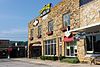 | September 17, 1985 (#85002222) | 103 E Main St 35°52′08″N 92°07′08″W / 35.868889°N 92.118889°W / 35.868889; -92.118889 (C.B. Case Motor Co. Building) | Mountain View | |
| 14 | Clark-King House |  | September 17, 1985 (#85002234) | Northeast of Mountain View 35°53′04″N 92°07′32″W / 35.884444°N 92.125556°W / 35.884444; -92.125556 (Clark-King House) | Mountain View | |
| 15 | Commercial Hotel |  | September 17, 1985 (#85002223) | 100 W Washington St 35°52′10″N 92°07′03″W / 35.869444°N 92.1175°W / 35.869444; -92.1175 (Commercial Hotel) | Mountain View | |
| 16 | Henry Copeland House | 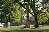 | September 17, 1985 (#85002224) | Highway 14 35°48′56″N 91°54′29″W / 35.815556°N 91.908056°W / 35.815556; -91.908056 (Henry Copeland House) | Pleasant Grove | |
| 17 | Wesley Copeland House | Upload image | September 17, 1985 (#85002208) | Southeast of Timbo 35°51′11″N 92°18′25″W / 35.853056°N 92.306944°W / 35.853056; -92.306944 (Wesley Copeland House) | Timbo | |
| 18 | Davis Barn | Upload image | September 17, 1985 (#85002225) | West of Pleasant Grove 35°48′43″N 91°55′40″W / 35.811944°N 91.927778°W / 35.811944; -91.927778 (Davis Barn) | Pleasant Grove | |
| 19 | Dew Drop Inn |  | September 17, 1985 (#85002231) | 307 W. Washington St. 35°52′10″N 92°07′13″W / 35.869444°N 92.120278°W / 35.869444; -92.120278 (Dew Drop Inn) | Mountain View | |
| 20 | William Dillard Homestead |  | September 17, 1985 (#85002214) | Near the White River 35°56′00″N 92°02′04″W / 35.933333°N 92.034444°W / 35.933333; -92.034444 (William Dillard Homestead) | Round Bottom | |
| 21 | H.J. Doughtery House | Upload image | September 17, 1985 (#85002232) | Highway 14 35°47′31″N 91°53′03″W / 35.791944°N 91.884167°W / 35.791944; -91.884167 (H.J. Doughtery House) | Marcella | |
| 22 | Farmers and Merchants Bank | 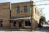 | September 17, 1985 (#85002228) | Highway 66 35°52′07″N 92°07′02″W / 35.868611°N 92.117222°W / 35.868611; -92.117222 (Farmers and Merchants Bank) | Mountain View | |
| 23 | Zachariah Ford House | 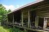 | September 17, 1985 (#85002206) | Near the White River 35°51′07″N 91°52′04″W / 35.851944°N 91.867778°W / 35.851944; -91.867778 (Zachariah Ford House) | Pleasant Grove | |
| 24 | Fox Pictograph | Upload image | May 4, 1982 (#82002143) | Address Restricted | Fox | |
| 25 | Orvall Gammill Barn |  | September 17, 1985 (#85002229) | Northwest of Big Springs 35°54′36″N 92°16′25″W / 35.91°N 92.273611°W / 35.91; -92.273611 (Orvall Gammill Barn) | Big Springs | |
| 26 | Walter Gray House |  | September 17, 1985 (#85002212) | Off Highway 14 35°44′20″N 91°51′04″W / 35.738889°N 91.851111°W / 35.738889; -91.851111 (Walter Gray House) | Melrose | |
| 27 | Joe Guffey House | Upload image | September 17, 1985 (#85002211) | Highway 110 35°43′12″N 92°24′34″W / 35.72°N 92.409444°W / 35.72; -92.409444 (Joe Guffey House) | Old Lexington | No longer standing |
| 28 | Binks Hess House and Barn | Upload image | September 17, 1985 (#85002227) | Off Highway 14 35°47′20″N 91°52′53″W / 35.788889°N 91.881389°W / 35.788889; -91.881389 (Binks Hess House and Barn) | Marcella | |
| 29 | Thomas E. Hess House |  | December 27, 1983 (#83003548) | Highway 14 35°47′19″N 91°53′05″W / 35.788611°N 91.884722°W / 35.788611; -91.884722 (Thomas E. Hess House) | Marcella | |
| 30 | Thomas M. Hess House | Upload image | September 17, 1985 (#85002226) | Off Highway 14 35°47′24″N 91°52′45″W / 35.79°N 91.879167°W / 35.79; -91.879167 (Thomas M. Hess House) | Marcella | |
| 31 | Miles Jeffery Barn | Upload image | September 17, 1985 (#85002215) | Off Highway 5 35°59′11″N 92°07′21″W / 35.986389°N 92.1225°W / 35.986389; -92.1225 (Miles Jeffery Barn) | Optimus | |
| 32 | Lackey General Merchandise and Warehouse |  | September 17, 1985 (#85002233) | Highway 66 35°52′07″N 92°07′03″W / 35.868611°N 92.1175°W / 35.868611; -92.1175 (Lackey General Merchandise and Warehouse) | Mountain View | |
| 33 | George W. Lackey House |  | October 2, 1990 (#90000992) | Junction of King and Washington Sts. 35°52′10″N 92°07′07″W / 35.869444°N 92.118611°W / 35.869444; -92.118611 (George W. Lackey House) | Mountain View | |
| 34 | Albert and Almeda Lancaster House | Upload image | September 7, 2021 (#100006931) | 306 East Main St. 35°52′02″N 92°06′52″W / 35.8671°N 92.1144°W / 35.8671; -92.1144 (Albert and Almeda Lancaster House) | Mountain View | |
| 35 | Fred Lancaster Barn |  | September 17, 1985 (#85002213) | Near the White River 35°56′19″N 92°02′45″W / 35.938611°N 92.045833°W / 35.938611; -92.045833 (Fred Lancaster Barn) | Round Bottom | |
| 36 | Luber School |  | September 4, 1992 (#92001124) | County Road 214 35°46′11″N 92°05′15″W / 35.769722°N 92.0875°W / 35.769722; -92.0875 (Luber School) | Luber | |
| 37 | H.S. Mabry Barn |  | September 17, 1985 (#85002236) | Near Johnson Creek 35°49′11″N 92°06′53″W / 35.819722°N 92.114722°W / 35.819722; -92.114722 (H.S. Mabry Barn) | East Richwoods | |
| 38 | Marcella Church & School |  | September 17, 1985 (#85002237) | Highway 14 35°47′16″N 91°53′03″W / 35.787778°N 91.884167°W / 35.787778; -91.884167 (Marcella Church & School) | Marcella | |
| 39 | Owen Martin House |  | October 25, 1985 (#85003397) | Highway 14 35°47′14″N 91°53′07″W / 35.787222°N 91.885278°W / 35.787222; -91.885278 (Owen Martin House) | Marcella | |
| 40 | Noah McCarn House | Upload image | September 17, 1985 (#85002238) | Highway 5 35°49′16″N 92°02′27″W / 35.821111°N 92.040833°W / 35.821111; -92.040833 (Noah McCarn House) | Mountain View | Demolished in 2010 |
| 41 | Mirror Lake Historic District |  | September 11, 1995 (#94001614) | Forest Service Road 1110E 35°57′37″N 92°10′26″W / 35.960278°N 92.173889°W / 35.960278; -92.173889 (Mirror Lake Historic District) | Ozark National Forest | |
| 42 | Jim Morris Barn | Upload image | September 17, 1985 (#85002209) | Highway 66 35°52′07″N 92°18′40″W / 35.868611°N 92.311111°W / 35.868611; -92.311111 (Jim Morris Barn) | Timbo | |
| 43 | Mountain View Waterworks |  | October 5, 2006 (#06000906) | Junction of Clarence St. and King St. 35°52′22″N 92°07′10″W / 35.872778°N 92.119444°W / 35.872778; -92.119444 (Mountain View Waterworks) | Mountain View | |
| 44 | Newton Sutterfield Farmstead |  | May 20, 2003 (#03000398) | 1797 Horton Hill Rd. 35°54′44″N 92°23′29″W / 35.912222°N 92.391389°W / 35.912222; -92.391389 (Newton Sutterfield Farmstead) | Alco | |
| 45 | Noricks Chapel School |  | June 4, 1998 (#98000615) | Meisenheimer Rd., 10 miles southeast of Mountain View 35°47′08″N 92°01′12″W / 35.785556°N 92.02°W / 35.785556; -92.02 (Noricks Chapel School) | Mountain View | |
| 46 | North Sylamore Creek Bridge | Upload image | February 24, 2010 (#10000034) | Forest Service Road 1102 over N. Sylamore Creek 35°59′44″N 92°12′46″W / 35.99555°N 92.212736°W / 35.99555; -92.212736 (North Sylamore Creek Bridge) | Ozark National Forest | |
| 47 | Pictograph Cave | Upload image | May 4, 1982 (#82002144) | Address Restricted | Mountain View | |
| 48 | Pinky Pruitt Barn |  | September 17, 1985 (#85002239) | Highway 14 35°50′17″N 91°56′07″W / 35.838056°N 91.935278°W / 35.838056; -91.935278 (Pinky Pruitt Barn) | St. James | |
| 49 | Roasting Ear Church and School |  | September 17, 1985 (#85002230) | Northeast of Onia 35°56′51″N 92°17′20″W / 35.9475°N 92.288889°W / 35.9475; -92.288889 (Roasting Ear Church and School) | Onia | |
| 50 | C.L. Smith & Son General Store |  | September 17, 1985 (#85002240) | Highway 66 35°52′06″N 92°07′05″W / 35.868333°N 92.118056°W / 35.868333; -92.118056 (C.L. Smith & Son General Store) | Mountain View | |
| 51 | Stegall General Store |  | September 17, 1985 (#85002241) | 104 W. Main St. 35°52′06″N 92°07′05″W / 35.868333°N 92.118056°W / 35.868333; -92.118056 (Stegall General Store) | Mountain View | |
| 52 | Stone County Courthouse |  | September 29, 1976 (#76000470) | Courthouse Sq. 35°52′08″N 92°07′05″W / 35.868889°N 92.118056°W / 35.868889; -92.118056 (Stone County Courthouse) | Mountain View | |
| 53 | Sugarloaf Fire Tower Historic District | Upload image | September 11, 1995 (#94001615) | Forest Service Road 1123 36°05′02″N 92°09′48″W / 36.083889°N 92.163333°W / 36.083889; -92.163333 (Sugarloaf Fire Tower Historic District) | Ozark National Forest | |
| 54 | Sylamore Creek Bridge |  | November 18, 1999 (#99001353) | County Road 283 over Sylamore Creek 35°56′09″N 92°07′18″W / 35.935833°N 92.121667°W / 35.935833; -92.121667 (Sylamore Creek Bridge) | Allison | |
| 55 | Taylor-Stokes House | Upload image | September 17, 1985 (#85002207) | Off Highway 14 35°45′36″N 91°51′57″W / 35.76°N 91.865833°W / 35.76; -91.865833 (Taylor-Stokes House) | Marcella | |
| 56 | Turkey Creek School | 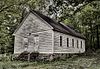 | October 25, 1985 (#85003396) | Highway 9 35°45′31″N 92°13′54″W / 35.758611°N 92.231667°W / 35.758611; -92.231667 (Turkey Creek School) | Turkey Creek | |
| 57 | West Richwoods Church & School | 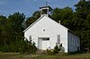 | September 17, 1985 (#85002205) | Highway 9 35°49′35″N 92°10′19″W / 35.826389°N 92.171944°W / 35.826389; -92.171944 (West Richwoods Church & School) | West Richwoods |
Former listings
| [3] | Name on the Register | Image | Date listed | Date removed | Location | City or town | Description |
|---|---|---|---|---|---|---|---|
| 1 | John L. Lancaster House | Upload image | September 17, 1985 (#85002235) | May 27, 2014 | Off AR 66 | Mountain View | Part of the Stone County MRA |
| 2 | Stone County Recorder Building | Upload image | September 17, 1985 (#85002242) | May 27, 2014 | Off AR 66 | Mountain View | Part of the Stone County MRA |
See also
Wikimedia Commons has media related to National Register of Historic Places in Stone County, Arkansas.
- List of National Historic Landmarks in Arkansas
- National Register of Historic Places listings in Arkansas
References
- ^ The latitude and longitude information provided in this table was derived originally from the National Register Information System, which has been found to be fairly accurate for about 99% of listings. Some locations in this table may have been corrected to current GPS standards.
- ^ National Park Service, United States Department of the Interior, "National Register of Historic Places: Weekly List Actions", retrieved September 5, 2024.
- ^ a b Numbers represent an alphabetical ordering by significant words. Various colorings, defined here, differentiate National Historic Landmarks and historic districts from other NRHP buildings, structures, sites or objects.
- ^ "National Register Information System". National Register of Historic Places. National Park Service. March 13, 2009.
- ^ The eight-digit number below each date is the number assigned to each location in the National Register Information System database, which can be viewed by clicking the number.
- v
- t
- e
- List of U.S. National Historic Landmarks by state:
- Alabama
- Alaska
- Arizona
- Arkansas
- California
- Colorado
- Connecticut
- Delaware
- Florida
- Georgia
- Hawaii
- Idaho
- Illinois
- Indiana
- Iowa
- Kansas
- Kentucky
- Louisiana
- Maine
- Maryland
- Massachusetts
- Michigan
- Minnesota
- Mississippi
- Missouri
- Montana
- Nebraska
- Nevada
- New Hampshire
- New Jersey
- New Mexico
- New York
- North Carolina
- North Dakota
- Ohio
- Oklahoma
- Oregon
- Pennsylvania
- Rhode Island
- South Carolina
- South Dakota
- Tennessee
- Texas
- Utah
- Vermont
- Virginia
- Washington
- West Virginia
- Wisconsin
- Wyoming
 National Register of Historic Places portal
 Category


Municipalities and communities of Stone County, Arkansas, United States | ||
|---|---|---|
County seat: Mountain View | ||
| Cities |  | |
| CDPs | ||
| Other unincorporated communities | ||
| Ghost town | ||
| ||


