Pilica, Masovian Voivodeship
Village in Masovian Voivodeship, Poland
51°48′30″N 21°15′30″E / 51.80833°N 21.25833°E / 51.80833; 21.25833 Poland
Pilica (Polish pronunciation: [piˈlit͡sa]) is a village in the administrative district of Gmina Warka, within Grójec County, Masovian Voivodeship, in east-central Poland.[1] It lies approximately 4 kilometres (2 mi) north-east of Warka, 28 km (17 mi) east of Grójec, and 50 km (31 mi) south of Warsaw.
The village lies on the higher, left bank of the Pilica River, about 9 km upstream from where it now joins the Vistula. In the Middle Ages, the settlement's location on the western scarp of the Vistula River valley marked the then confluence of the two rivers, resulting in the village sharing the name of the river;[2] however there is another small town also called Pilica, which lies near the source of the same river.
During World War II the area was heavily fought over and the village was in the front line for five months from the beginning of August 1944 when the Soviet army established a strategic bridgehead at Magnuszew on the west bank of the Vistula, followed by German counterattacks, until the successful Soviet breakout on 12 January 1945.
References
Historical photos
-
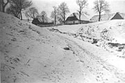 Houses in Pilica, c.1939
 -
 Spire of Evangelical Lutheran church (Kościół Ewangelicko-Augsburski) in Pilica, c.1939
 -
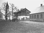 Evangelical Lutheran church and manse in Pilica, c.1939


- v
- t
- e

- Bończa
- Borowe
- Branków
- Brzezinki
- Budy Michałowskie
- Budy Opożdżewskie
- Dębnowola
- Gąski
- Gośniewice
- Grażyna
- Grzegorzewice
- Gucin
- Hornigi
- Kalina
- Kazimierków
- Klonowa Wola
- Konary
- Krześniaków
- Laski
- Lechanice
- Magierowa Wola
- Michalczew
- Michałów Dolny
- Michałów Górny
- Michałów-Parcele
- Murowanka
- Niwy Ostrołęckie
- Nowa Ostrołęka
- Nowa Wieś
- Nowe Biskupice
- Nowe Grzegorzewice
- Opożdżew
- Oskardów
- Ostrołęka
- Ostrówek
- Palczew
- Palczew-Parcela
- Paulin
- Piaseczno
- Pilica
- Podgórzyce
- Prusy
- Przylot
- Stara Warka
- Stare Biskupice
- Wichradz
- Wola Palczewska
- Wrociszew
- Zastruże
| Authority control databases |
|
|---|
 | This Grójec County location article is a stub. You can help Wikipedia by expanding it. |
- v
- t
- e


