Sakaraha (district)
Place in Atsimo-Andrefana, Madagascar
Sakaraha | |
|---|---|
 | |
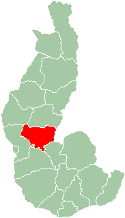 Map of former Toliara Province showing the location of Sakaraha (red). | |
| Country | Madagascar |
| Region | Atsimo-Andrefana |
Sakaraha is a district located in Atsimo-Andrefana Region, south-western Madagascar.
Communes
The district is further divided into 11 communes:
- Ambinany
- Amboronabo
- Andalamasina Vineta
- Andranolava
- Bereketa
- Mahaboboka
- Miary Lamatihy
- Miary Taheza
- Mihavatsy
- Mikoboka
- Mitsinjo, Sakaraha
- Sakaraha
Geography
Sakaraha is situated along route nationale No. 7 (Tuléar-Fianarantsoa) at 134 km from Tuléar, 64 km from Andranovory and 84 km from Ilakaka.[1] Zombitse-Vohibasia National Park is located in the district, east of the town of Sakaraha. Analavelona Massif is in the western portion of the district.
References
- ^ Atlas Mondial, France Loisir, page 159
22°55′0″S 44°32′59″E / 22.91667°S 44.54972°E / -22.91667; 44.54972

- v
- t
- e

Capital: Toliara

- Ambatolahy
- Andranomafana
- Ankazoabo
- Ankeriky
- Ankilivalokely
- Ántevamena
- Berenty
- Fotivolo
- Ilemby
- Tandrano
- Ambalavato
- Ankilimary
- Benenitra
- Benonoky
- Ehara
- Ianapera
- Behisatra (Behisatsy)
- Bemavo
- Beroroha
- Fanjakana
- Mandronarivo
- Marerano
- Sakena
- Tanamary
- Tanandava
- Ambatry Mitsinjo
- Ankazomanga Ouest
- Ankazombalala
- Andranomangatsiaka
- Ankilivalo
- Antohabato
- Antsavoa
- Atsimo I
- Atsimo II
- Beantake
- Beavoha
- Belamoty
- Beora
- Besely
- Betioky
- Bezaha
- Efoetsy
- Fenoandala
- Lazarivo
- Manalobe
- Masiaboay
- Maroarivo Ankazomanga
- Montifeno
- Salobe
- Savazy II
- Sakamasay
- Soamanonga
- Soaserana
- Tameantsoa
- Tanambao Ambony
- Tongobory
- Vatolatsaka
- Vohimary
9 districts; 119 communes
 | This Atsimo-Andrefana location article is a stub. You can help Wikipedia by expanding it. |
- v
- t
- e


