Suggan Buggan, Victoria
Locality in Victoria, Australia

Suggan Buggan is a ghost town in the remote wilderness of north-eastern Gippsland in Victoria, Australia, 8 km from the border with New South Wales.[1][2] About five or six people live there permanently. The postcode is 3885.
The traditional custodians of the area are the Australian Aboriginal Bidawal and Nindi-Ngudjam Ngarigu Monero peoples.[3] The name of the locality supposedly derives from the Aboriginal phrase "bukkan bukkan", which describes bags made from grass.[4]
Suggan Buggan is surrounded by the Alpine National Park. There is a free camping area on the Suggan Buggan River. Several historical remains exist, including a well preserved 1860s wooden schoolhouse and an old house.
Gallery
-
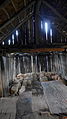 Interior of the schoolhouse.
 -
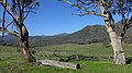 Farming area around Suggan Buggan


References
- ^ "Suggan Buggan". Victoria. Retrieved 19 September 2022.
- ^ "Suggan Buggan, Victoria: Travel guide and things to do". Traveller. 23 January 2015. Retrieved 19 September 2022.
- ^ "Snowy River National Park". Parks Victoria. Archived from the original on 2 October 2011. Retrieved 23 January 2023.
- ^ "Suggan Buggan". Sydney Morning Herald. 8 February 2004. Retrieved 22 January 2023.
36°57′14″S 148°19′45″E / 36.9538°S 148.3293°E / -36.9538; 148.3293
- v
- t
- e
Some localities in the Shire of East Gippsland
- Anglers Rest
- Bairnsdale
- Bemm River
- Benambra
- Bendoc
- Bruthen
- Buchan
- Cann River
- Cassilis
- Clifton Creek
- Eagle Point
- Ensay
- Fernbank
- Genoa
- Goon Nure
- Johnsonville
- Lakes Entrance
- Lindenow
- Lucknow
- Mallacoota
- Marlo
- Metung
- Newmerella
- Nicholson
- Nowa Nowa
- Omeo
- Orbost
- Paynesville
- Raymond Island
- Swan Reach
- Swifts Creek
- Tambo Crossing
- Tongio
- W Tree
- Wy Yung

 | This article about a location in Gippsland (region) is a stub. You can help Wikipedia by expanding it. |
- v
- t
- e
| This article about a location in Victoria, Australia is a stub. You can help Wikipedia by expanding it. |
- v
- t
- e
 | This Australian ghost town-related article is a stub. You can help Wikipedia by expanding it. |
- v
- t
- e


