Breaksea Sound
Fiord on the southwestern coast of South Island, New Zealand
45°34′S 166°47′E / 45.57°S 166.78°E / -45.57; 166.78
Te Puaitaha / Breaksea Sound is a small fiord on the southwestern coast of South Island, New Zealand in the Tasman Sea. Breaksea Island in Fiordland National Park lies at its entrance. In the 1850s, early settlers Henry Hirst and John Watts-Russell explored the area for flat land suitable for sheep farming, but they were unsuccessful.[1] In October 2019, the name of the fiord was officially altered to Te Puaitaha / Breaksea Sound.[2]
Gallery
-
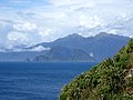 Breaksea Island at the entry to Te Puaitaha / Breaksea Sound.
 -
 2022 satellite image of Te Puaitaha / Breaksea Sound, showing bleached sea sponges
 -
 19th century sketch of the Narrows in Breaksea Sound by Charles Heaphy


References
- v
- t
- e
Fiordland, New Zealand
- Doubtful Sound / Patea
- Deep Cove
- Hāwea / Bligh Sound
- Hinenui / Nancy Sound
- Bradshaw Sound
- Milford Sound
- Taiari / Chalky Inlet
- Charles Sound
- Caswell Sound
- Tamatea / Dusky Sound
- Thompson Sound
- Sutherland Sound
- George Sound
- Breaksea Sound
- Dagg Sound
- Rakituma / Preservation Inlet
- Big Bay
- Martins Bay
- Pearl Harbour
- Te Waewae Bay
- Anchor Island
- Arran Island
- Bauza Island
- Bay Rock
- Belle Vue Island
- Breaksea Island
- Brig Rock
- Buncrana Island
- Centre Island
- Chalky Island
- Coal Island
- Cooper Island
- Elizabeth Island
- Great Island
- Indian Island
- Long Island
- Pomona Island
- Resolution Island
- Secretary Island
- Hawea (Clio Rocks)
- Kahukura (Gold Arm)
- Kutu Parera (Gaer Arm)
- Moana Uta (Wet Jacket Arm)
- Piopiotahi (Milford Sound)
- Taipari Roa (Elizabeth Island)
- Taumoana (Five Finger Peninsula)
- Te Awaatu Channel (The Gut)
- Te Hapua (Sutherland Sound)
- Te Tapuwae o Hua (Long Sound)
- Darran Mountains
- Franklin Mountains
- Humboldt Mountains
- Hunter Mountains
- Kepler Mountains
- Murchison Mountains
- Wick Mountains
- Mitre Peak
- Mount Edgecumbe
- Mount Grono
- Mount Luxmore
- Mount Moturau
- Mount Richardson
- Mount Titiroa
- Mount Tūtoko
- Aan River
- Arthur River
- Awarua River
- Big River
- Bowen River
- Camelot River
- Carrick River
- Castle River
- Cavendish River
- Cleddau River
- Clinton River
- Coal River
- Dark River
- Donne River
- Doon River
- Dry Awarua River
- Edith River
- Eglinton River
- Electric River
- Elizabeth River
- Forgotten River
- George River
- Glaisnock River
- Gray River
- Grebe River
- Gulliver River
- Hollyford River
- Irene River
- John o'Groats River
- Juno River
- Kaipo River
- Light River
- Lyvia River
- Mike River
- Misty River
- Monowai River
- Namu River
- Newton River
- Olivine River
- Pandora River
- Pitt River
- Pyke River
- Rea River
- Red Pyke River
- Rooney River
- Seaforth River
- Shag River
- Spey River
- Stillwater River
- Talbot River
- Thurso River
- Transit River
- Tūtoko River
- Waiau River
- Waikōau River
- Wairaurāhiri River
- Waitutu River
- Walker River
- Wapiti River
- Whitewater River
- Wild Natives River
- Wilmot River
- Wilson River
- Windward River
- Wolff River
- Manapouri
- Milford Sound
- Port Craig
- Te Anau
 | This Fiordland, New Zealand geography article is a stub. You can help Wikipedia by expanding it. |
- v
- t
- e
 | This article about a fjord is a stub. You can help Wikipedia by expanding it. |
- v
- t
- e


