Beit Safafa
Beit Safafa | |
|---|---|
Lingkungan | |
| Negara | |
| Provinsi | Yerusalem |
| Kota | Yerusalem |
| Zona waktu | UTC+3 (EAT) |
| • Musim panas (DST) | UTC+3 (EAT) |
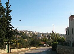
Beit Safafa (bahasa Arab: بيت صفافا, Ibrani: בית צפפה;[1]) adalah kota atau lingkungan Arab di sepanjang Garis Hijau, dengan sebagian besar wilayahnya berada dalam wilayah Yerusalem Timur dan bagian utara lainnya berada di Yerusalem Barat.[2] Beit Safafa mencakup wilayah seluas 1,577 dunam[3] dan memiliki populasi sebanyak 5,463.[4]
Referensi
- ^ Palmer, 1881, p. 287
- ^ Tearing a neighbourhood in two. Ir Amim, February 2013
- ^ Amir Cheshin; Bill Hutman & Avi Melamed (1999). Separate and Unequal: the Inside Story of Israeli Rule in East Jerusalem. Harvard University Press. hlm. 136.
- ^ "Beit Safafa Housing Project 2010". Diarsipkan dari versi asli tanggal 2017-11-07. Diakses tanggal 2016-12-29.
Bibliografi
Wikimedia Commons memiliki media mengenai Beit Safafa.
- Barron, J. B., ed. (1923). Palestine: Report and General Abstracts of the Census of 1922. Government of Palestine.
- Barzel, Vered (2007-12-18), Jerusalem, Beit Safafa (West) (119), Hadashot Arkheologiyot – Excavations and Surveys in Israel
- Conder, Claude Reignier; Kitchener, H. H. (1883). The Survey of Western Palestine: Memoirs of the Topography, Orography, Hydrography, and Archaeology. 3. London: Committee of the Palestine Exploration Fund.
- Department of Statistics (1945). Village Statistics, April, 1945. Government of Palestine.
- Eirikh-Rose, Anna; Levi, Danit (2012-12-31), Jerusalem, Beit Safafa (124), Hadashot Arkheologiyot – Excavations and Surveys in Israel [pranala nonaktif permanen]
- Finn, James (1878). Elizabeth A. Finn, ed. Stirring Times, or, Records from Jerusalem Consular Chronicles of 1853 to 1856. Edited and Compiled by His Widow E. A. Finn. With a Preface by the Viscountess Strangford. 2. London: C.K. Paul & co. p. 215
- Guérin, Victor (1869). Description Géographique Historique et Archéologique de la Palestine (dalam bahasa French). 1: Judee, pt. 2. Paris: L'Imprimerie Nationale. Pemeliharaan CS1: Bahasa yang tidak diketahui (link)
- Hadawi, Sami (1970). Village Statistics of 1945: A Classification of Land and Area ownership in Palestine. Palestine Liberation Organization Research Center.
- Hütteroth, Wolf-Dieter; Abdulfattah, Kamal (1977). Historical Geography of Palestine, Transjordan and Southern Syria in the Late 16th Century. Erlanger Geographische Arbeiten, Sonderband 5. Erlangen, Germany: Vorstand der Fränkischen Geographischen Gesellschaft. ISBN 3-920405-41-2.
- Mills, E., ed. (1932). Census of Palestine 1931. Population of Villages, Towns and Administrative Areas (PDF). Jerusalem: Government of Palestine.
- Palmer, E. H. (1881). The Survey of Western Palestine: Arabic and English Name Lists Collected During the Survey by Lieutenants Conder and Kitchener, R. E. Transliterated and Explained by E.H. Palmer. Committee of the Palestine Exploration Fund.
- Pringle, Denys (1997). Secular buildings in the Crusader Kingdom of Jerusalem: an archaeological Gazetter. Cambridge University Press.
- Röhricht, Reinhold (1893). (RRH) Regesta regni Hierosolymitani (MXCVII-MCCXCI) (dalam bahasa Latin). Berlin: Libraria Academica Wageriana.
- Zilberbod, Irina (2007-12-20), Jerusalem, Beit Safafa Final Report (119), Hadashot Arkheologiyot – Excavations and Surveys in Israel
Pranala luar
- Welcome To Bayt Safafa
- Survey of Western Palestine, Map 17: IAA, Wikimedia commons
- Beit Safafa and Sharafat (Fact Sheet), ARIJ
- Beit Safafa & Sharafat Town Profile, ARIJ
- Beit Safafa & Sharafat aerial photo, ARIJ
- The Mashrabiya House, Beit Safafa, ARIJ
Koordinat: 31°44′38″N 35°12′20″E / 31.74389°N 35.20556°E / 31.74389; 35.20556
Lingkungan di Yerusalem | ||
|---|---|---|
Lingkungan-lingkungan Yerusalem sebelah timur garis gencatan senjata tahun 1949 digambarkan dengan warna hijau, sedangkan sebelah barat dari garis tersebut digambarkan dalam warna biru (lihat Garis Hijau). | ||
| Kota Lama |
|  |
| Lingkungan Tengah |
| |
| Lingkungan Utara |
| |
| Lingkungan Timur |
| |
| Lingkungan Selatan |
| |
| Lingkungan Barat | ||
| Lingkungan bersejarah |
| |
Lihat pula: Lingkaran Lingkungan | ||
Pengawasan otoritas | |
|---|---|
| Umum |
|
| Perpustakaan nasional |
|
 | Artikel bertopik geografi atau tempat Israel ini adalah sebuah rintisan. Anda dapat membantu Wikipedia dengan mengembangkannya. |
- l
- b
- s


