Tulkarm
Lambang Tulkarm
(2007)

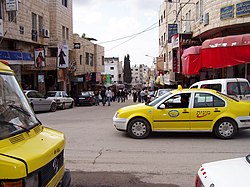
Tulkarm atau Tulkarem (Arab: طولكرم, Ṭūlkarm); adalah sebuah kota Palestina di Tepi Barat, yang terletak di Kegubernuran Tulkarm. Kota Israel Netanya dan Haifa berada di sebelah baratnya, dan kota Palestina Nablus dan Jenin berada di sebelah timurnya. Menurut Biro Pusat Statistik Palestina pada 2007, Tulkarm memiliki penduduk sejumlah 51,300 orang sementara kamp pengungsi-nya memiliki penduduk sejumlah 10,641 orang.[2]
Referensi
Daftar pustaka
Wikimedia Commons memiliki media mengenai Tulkarm.
- Barron, J. B., ed. (1923). Palestine: Report and General Abstracts of the Census of 1922 (PDF). Government of Palestine.
- Conder, Claude Reignier; Kitchener, Herbert H. (1882). The Survey of Western Palestine: Memoirs of the Topography, Orography, Hydrography, and Archaeology. 2. London: Committee of the Palestine Exploration Fund.
- Doumani, Beshara (1995). "Rediscovering Palestine, Merchants and Peasants in Jabal Nablus, 1700-1900". University of California Press.
- Guérin, Victor (1875). Description Géographique Historique et Archéologique de la Palestine (dalam bahasa French). 2: Samarie, pt. 2. Paris: L'Imprimerie Nationale. Pemeliharaan CS1: Bahasa yang tidak diketahui (link)
- Hadawi, Sami (1970). Village Statistics of 1945: A Classification of Land and Area ownership in Palestine. Palestine Liberation Organization Research Center.
- Hütteroth, Wolf-Dieter; Abdulfattah, Kamal (1977). Historical Geography of Palestine, Transjordan and Southern Syria in the Late 16th Century. Erlanger Geographische Arbeiten, Sonderband 5. Erlangen, Germany: Vorstand der Fränkischen Geographischen Gesellschaft. ISBN 0-88728-224-5.
- Karmon, Y. (1960). "An Analysis of Jacotin's Map of Palestine" (PDF). Israel Exploration Journal. 10 (3,4): 155–173; 244–253. Diarsipkan dari versi asli (PDF) tanggal 2019-12-22. Diakses tanggal 2015-12-14.
- Mills. E., ed. (1932). Census of Palestine 1931. Population of Villages, Towns and Administrative Areas (PDF). Jerusalem: Government of Palestine.
- Palmer, E. H. (1881). The Survey of Western Palestine: Arabic and English Name Lists Collected During the Survey by Lieutenants Conder and Kitchener, R. E. Transliterated and Explained by E.H. Palmer. Committee of the Palestine Exploration Fund.
- Thawaba, Salem (2009). "Urban growth of a city under siege: Tulkarm, Palestine over the past century". Journal of Planning History. 28: 27–46.
Pranala luar
- Welcome To Tulkarm R.C.
- Survey of Western Palestine, Map 11: IAA, Wikimedia commons
- Al-Salim, Farid. Tulkarm Landed Property and Elite Conflict in Ottoman Tulkarm Jerusalem Quarterly.
- Official website www.tulkarm.org Diarsipkan 2022-02-16 di Wayback Machine.
- www.mtulkarm.com
Kebugernuran Tulkarm | ||
|---|---|---|
| Kota |
|   |
| Munisipalitas |
| |
| Desa |
| |
| Kamp pengungsi |
| |


