Capel-le-Ferne
| Państwo |
|
|---|---|
| Kraj |
|
| Region | South East |
| Hrabstwo | Kent |
| Dystrykt | Dover |
| Populacja (2015) • liczba ludności |
|
| Nr kierunkowy | 01303 |
| Kod pocztowy | CT18 |
Położenie na mapie Kentu  | |
Położenie na mapie Wielkiej Brytanii  | |
Położenie na mapie Anglii  | |
 51°06′13″N 1°12′06″E/51,103611 1,201667 51°06′13″N 1°12′06″E/51,103611 1,201667 | |


Capel-le-Ferne – wieś w Anglii, w hrabstwie Kent, w dystrykcie Dover. Leży 21 km na południowy wschód od miasta Canterbury i 103 km na południowy wschód od centrum Londynu[2]. W 2015 miejscowość liczyła 2430 mieszkańców[1].
- Battle of Britain Memorial
-

-
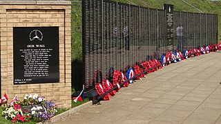 Memorial Wall
 -
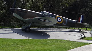 Airplane


Przypisy
- ↑ a b Business Intelligence Statistical Bulletin. 2015 Mid-year population estimates: Ward level population in Kent. Strategic Business Development & Intelligence, Kent County Council, listopad 2016. s. 11. [dostęp 2018-08-13]. (ang.).
- ↑ Capel-le-Ferne na mapie. getamap.ordnancesurvey.co.uk. [dostęp 2010-10-06]. (ang.).


