Mongsang
| Mongsang (Möngsang) | |||||||||
|---|---|---|---|---|---|---|---|---|---|
| State of the Shan States in personal union with Monghsu | |||||||||
| 1857–1959 | |||||||||
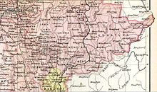 Möng Sang State in an Imperial Gazetteer of India map | |||||||||
| Area | |||||||||
• 1901 | 2,650 km2 (1,020 sq mi) | ||||||||
| Population | |||||||||
• 1901 | 30,482 | ||||||||
| History | |||||||||
• State founded | 1857 | ||||||||
• Abdication of the last Myoza | 1959 | ||||||||
| |||||||||

Mongsang (also known as Maingsin) was a Shan state in what is today Burma.[1]
History
Mongsang became independent from Hsenwi in 1857 under a personal union with the neighbouring state of Monghsu. It was a tributary of Burma until 1887, when the Shan states submitted to British rule after the fall of the Konbaung dynasty.[2]
Rulers
The rulers of Möngsang/Monghsu bore the title of Myoza.[3]
Myozas
- 1857 - 1879 Hkun Mon
- 1879 - 1901 Hkun Maha
- 1901 - 1917 Hkun Kyaw (b. 1845 - d. 1917)
- 1917 - 19.. Hkun Sao (Hkun Saw) (b. 1845 - d. 19..)
References
External links
- "Gazetteer of Upper Burma and the Shan states"
- The Imperial Gazetteer of India
- v
- t
- e
- Hsenwi State
- Mongmit
- Hsipaw
- North Hsenwi
- South Hsenwi
- Hsumhsai
- Manglon
- Mongleng
- Monglong
- Mongtung
- Tawngpeng
Eastern Division
Central Division
Myelat Division
Kengtung & Yawnghwe
- Federated Shan states
- List of rulers of Shan states
- Princely state
- Saopha
21°48′N 98°21′E / 21.800°N 98.350°E / 21.800; 98.350
 | This Burmese history article is a stub. You can help Wikipedia by expanding it. |
- v
- t
- e
 | This Shan State location article is a stub. You can help Wikipedia by expanding it. |
- v
- t
- e


