National Register of Historic Places listings in Coffee County, Georgia
This is a list of properties and districts in Coffee County, Georgia that are listed on the National Register of Historic Places (NRHP).
Map all coordinates using OpenStreetMap
Download coordinates as:
- KML
- GPX (all coordinates)
- GPX (primary coordinates)
- GPX (secondary coordinates)
This National Park Service list is complete through NPS recent listings posted June 28, 2024.[1]
- v
- t
- e
Properties on the National Register of Historic Places in Georgia by county
- Appling
- Atkinson
- Bacon
- Baker
- Baldwin
- Banks
- Barrow
- Bartow
- Ben Hill
- Berrien
- Bibb
- Bleckley
- Brantley
- Brooks
- Bryan
- Bulloch
- Burke
- Butts
- Calhoun
- Camden
- Candler
- Carroll
- Catoosa
- Charlton
- Chatham
- Chattahoochee
- Chattooga
- Cherokee
- Clarke
- Clay
- Clayton
- Clinch
- Cobb
- Coffee
- Colquitt
- Columbia
- Cook
- Coweta
- Crawford
- Crisp
- Dade
- Dawson
- Decatur
- DeKalb
- Dodge
- Dooly
- Dougherty
- Douglas
- Early
- Echols
- Effingham
- Elbert
- Emanuel
- Evans
- Fannin
- Fayette
- Floyd
- Forsyth
- Franklin
- Fulton
- Gilmer
- Glascock
- Glynn
- Gordon
- Grady
- Greene
- Gwinnett
- Habersham
- Hall
- Hancock
- Haralson
- Harris
- Hart
- Heard
- Henry
- Houston
- Irwin
- Jackson
- Jasper
- Jeff Davis
- Jefferson
- Jenkins
- Johnson
- Jones
- Lamar
- Lanier
- Laurens
- Lee
- Liberty
- Lincoln
- Long
- Lowndes
- Lumpkin
- Macon
- Madison
- Marion
- McDuffie
- McIntosh
- Meriwether
- Miller
- Mitchell
- Monroe
- Montgomery
- Morgan
- Murray
- Muscogee
- Newton
- Oconee
- Oglethorpe
- Paulding
- Peach
- Pickens
- Pierce
- Pike
- Polk
- Pulaski
- Putnam
- Quitman
- Rabun
- Randolph
- Richmond
- Rockdale
- Schley
- Screven
- Seminole
- Spalding
- Stephens
- Stewart
- Sumter
- Talbot
- Taliaferro
- Tattnall
- Taylor
- Telfair
- Terrell
- Thomas
- Tift
- Toombs
- Towns
- Treutlen
- Troup
- Turner
- Twiggs
- Union
- Upson
- Walker
- Walton
- Ware
- Warren
- Washington
- Wayne
- Webster
- Wheeler
- White
- Whitfield
- Wilcox
- Wilkes
- Wilkinson
- Worth

Current listings
| [2] | Name on the Register | Image | Date listed[3] | Location | City or town | Description |
|---|---|---|---|---|---|---|
| 1 | 63rd Army Air Forces Contract Pilot School (Primary) |  | May 14, 2013 (#13000270) | 2700 S. Peterson Ave. 31°28′48″N 82°51′08″W / 31.48°N 82.8522°W / 31.48; -82.8522 (63rd Army Air Forces Contract Pilot School (Primary)) | Douglas | At the Douglas Municipal Airport, several buildings used to train pilots in World War II |
| 2 | Downtown Douglas Historic District |  | September 9, 1993 (#93000941) | Roughly bounded by Jackson St., Pearl Ave., Cherry St. and the Georgia-Florida RR tracks 31°30′25″N 82°51′02″W / 31.506944°N 82.850556°W / 31.506944; -82.850556 (Downtown Douglas Historic District) | Douglas | Union Banking Company in the Downtown Douglas Historic District |
| 3 | Eleventh District A & M School-South Georgia College Historic District |  | May 21, 2010 (#10000274) | Roughly bounded by College Park Dr., Brooks & Tiger Rds. 31°29′44″N 82°51′19″W / 31.495425°N 82.855214°W / 31.495425; -82.855214 (Eleventh District A & M School-South Georgia College Historic District) | Douglas | Includes other buildings at the college, contributing buildings were built 1907-58 |
| 4 | Gaskin Avenue Historic District |  | October 21, 1993 (#93001138) | Roughly bounded by Madison Ave., Wilson St., Pearl Ave., Gordon St., McDonald Ave., Atlantic Coastline RR and Coffee Ave 31°30′38″N 82°50′40″W / 31.510556°N 82.844444°W / 31.510556; -82.844444 (Gaskin Avenue Historic District) | Douglas | |
| 5 | Lonnie A. Pope House | 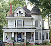 | June 17, 1982 (#82002395) | Jackson St. and Central of Georgia RR tracks (the RR tracks are no longer there - called "Douglas Trail" now) 31°30′39″N 82°51′09″W / 31.510833°N 82.8525°W / 31.510833; -82.8525 (Lonnie A. Pope House) | Douglas | Built in 1910 |
| 6 | Union Banking Company Building |  | December 10, 1982 (#82000144) | 102 Peterson Ave. 31°30′33″N 82°51′00″W / 31.50904°N 82.85011°W / 31.50904; -82.85011 (Union Banking Company Building) | Douglas | Built in 1911, also known as the Coffee County Bank |
References
- ^ National Park Service, United States Department of the Interior, "National Register of Historic Places: Weekly List Actions", retrieved June 28, 2024.
- ^ Numbers represent an alphabetical ordering by significant words. Various colorings, defined here, differentiate National Historic Landmarks and historic districts from other NRHP buildings, structures, sites or objects.
- ^ The eight-digit number below each date is the number assigned to each location in the National Register Information System database, which can be viewed by clicking the number.
Wikimedia Commons has media related to National Register of Historic Places in Coffee County, Georgia.


