National Register of Historic Places listings in Monroe County, Georgia
This is a list of properties and districts in Monroe County, Georgia that are listed on the National Register of Historic Places (NRHP).
Map all coordinates using OpenStreetMap
Download coordinates as:
- KML
- GPX (all coordinates)
- GPX (primary coordinates)
- GPX (secondary coordinates)
This National Park Service list is complete through NPS recent listings posted June 28, 2024.[1]
- v
- t
- e
Properties on the National Register of Historic Places in Georgia by county
- Appling
- Atkinson
- Bacon
- Baker
- Baldwin
- Banks
- Barrow
- Bartow
- Ben Hill
- Berrien
- Bibb
- Bleckley
- Brantley
- Brooks
- Bryan
- Bulloch
- Burke
- Butts
- Calhoun
- Camden
- Candler
- Carroll
- Catoosa
- Charlton
- Chatham
- Chattahoochee
- Chattooga
- Cherokee
- Clarke
- Clay
- Clayton
- Clinch
- Cobb
- Coffee
- Colquitt
- Columbia
- Cook
- Coweta
- Crawford
- Crisp
- Dade
- Dawson
- Decatur
- DeKalb
- Dodge
- Dooly
- Dougherty
- Douglas
- Early
- Echols
- Effingham
- Elbert
- Emanuel
- Evans
- Fannin
- Fayette
- Floyd
- Forsyth
- Franklin
- Fulton
- Gilmer
- Glascock
- Glynn
- Gordon
- Grady
- Greene
- Gwinnett
- Habersham
- Hall
- Hancock
- Haralson
- Harris
- Hart
- Heard
- Henry
- Houston
- Irwin
- Jackson
- Jasper
- Jeff Davis
- Jefferson
- Jenkins
- Johnson
- Jones
- Lamar
- Lanier
- Laurens
- Lee
- Liberty
- Lincoln
- Long
- Lowndes
- Lumpkin
- Macon
- Madison
- Marion
- McDuffie
- McIntosh
- Meriwether
- Miller
- Mitchell
- Monroe
- Montgomery
- Morgan
- Murray
- Muscogee
- Newton
- Oconee
- Oglethorpe
- Paulding
- Peach
- Pickens
- Pierce
- Pike
- Polk
- Pulaski
- Putnam
- Quitman
- Rabun
- Randolph
- Richmond
- Rockdale
- Schley
- Screven
- Seminole
- Spalding
- Stephens
- Stewart
- Sumter
- Talbot
- Taliaferro
- Tattnall
- Taylor
- Telfair
- Terrell
- Thomas
- Tift
- Toombs
- Towns
- Treutlen
- Troup
- Turner
- Twiggs
- Union
- Upson
- Walker
- Walton
- Ware
- Warren
- Washington
- Wayne
- Webster
- Wheeler
- White
- Whitfield
- Wilcox
- Wilkes
- Wilkinson
- Worth

Current listings
| [2] | Name on the Register | Image | Date listed[3] | Location | City or town | Description |
|---|---|---|---|---|---|---|
| 1 | Culloden Historic District |  | March 13, 1980 (#80001119) | Hickory Grove Rd., Main, College and Orange Sts. 32°51′51″N 84°05′48″W / 32.864167°N 84.096667°W / 32.864167; -84.096667 (Culloden Historic District) | Culloden | |
| 2 | Forsyth Commercial Historic District |  | January 13, 1983 (#83000239) | Main, Lee, Johnston, Adams, Jackson, Kimball, and Harris Sts. 33°02′04″N 83°56′20″W / 33.034444°N 83.938889°W / 33.034444; -83.938889 (Forsyth Commercial Historic District) | Forsyth | |
| 3 | Forsyth Railroad Depots and Baggage Room |  | July 23, 2013 (#13000532) | E. Adams St. 33°02′07″N 83°56′03″W / 33.03529°N 83.93427°W / 33.03529; -83.93427 (Forsyth Railroad Depots and Baggage Room) | Forsyth | |
| 4 | Front Circle, Tift College |  | February 8, 1980 (#80001120) | Tift College Dr. 33°02′08″N 83°55′57″W / 33.035556°N 83.9325°W / 33.035556; -83.9325 (Front Circle, Tift College) | Forsyth | |
| 5 | Great Hill Place |  | July 24, 1973 (#73000633) | W of Bolingbroke off GA 41 32°56′42″N 83°49′04″W / 32.945°N 83.817778°W / 32.945; -83.817778 (Great Hill Place) | Bolingbroke | |
| 6 | Hil'ardin/Sharp-Hardin-Wright House | Upload image | June 22, 1979 (#79000735) | 212 S. Lee St. 33°01′40″N 83°56′19″W / 33.02783°N 83.93853°W / 33.02783; -83.93853 (Hil'ardin/Sharp-Hardin-Wright House) | Forsyth | |
| 7 | Monroe County Courthouse |  | September 18, 1980 (#80001121) | Courthouse Sq. 33°02′03″N 83°56′20″W / 33.034167°N 83.938889°W / 33.034167; -83.938889 (Monroe County Courthouse) | Forsyth | |
| 8 | Montpelier Female Institute | 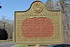 | October 10, 1975 (#75000602) | W of Macon 32°52′11″N 83°53′01″W / 32.869722°N 83.883611°W / 32.869722; -83.883611 (Montpelier Female Institute) | Macon | Historical marker at 32°51′54″N 83°52′55″W / 32.865105°N 83.882016°W / 32.865105; -83.882016 Down a private road, if it still exists |
| 9 | State Teachers and Agricultural College for Negroes Women's Dormitory and Teachers' Cottage | 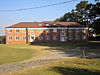 | May 30, 2003 (#03000475) | Martin Luther King Dr. 33°01′25″N 83°57′16″W / 33.02371°N 83.95447°W / 33.02371; -83.95447 (State Teachers and Agricultural College for Negroes Women's Dormitory and Teachers' Cottage) | Forsyth |
References
- ^ National Park Service, United States Department of the Interior, "National Register of Historic Places: Weekly List Actions", retrieved June 28, 2024.
- ^ Numbers represent an alphabetical ordering by significant words. Various colorings, defined here, differentiate National Historic Landmarks and historic districts from other NRHP buildings, structures, sites or objects.
- ^ The eight-digit number below each date is the number assigned to each location in the National Register Information System database, which can be viewed by clicking the number.
Wikimedia Commons has media related to National Register of Historic Places in Monroe County, Georgia.


