Grade II* listed buildings in North East Derbyshire
Map all coordinates using OpenStreetMap
Download coordinates as:
- KML
- GPX (all coordinates)
- GPX (primary coordinates)
- GPX (secondary coordinates)
There are over 20,000 Grade II* listed buildings in England. This page is a list of these buildings in the district of North East Derbyshire in Derbyshire.
List of buildings
| Name | Location | Type | Completed [note 1] | Date designated | Grid ref.[note 2] Geo-coordinates | Entry number [note 3] | Image |
|---|---|---|---|---|---|---|---|
| Barlow Woodseats | Barlow | House | 1624 | 25 October 1957 | SK3170475468 53°16′31″N 1°31′34″W / 53.275253°N 1.526027°W / 53.275253; -1.526027 (Barlow Woodseats) | 1087802 |  More images |
| Church of St Lawrence | Barlow | Church | Early 13th century | 31 January 1967 | SK3441974698 53°16′05″N 1°29′07″W / 53.268163°N 1.485398°W / 53.268163; -1.485398 (Church of St Lawrence) | 1033277 |  More images |
| Ogston Hall and attached stable block | Brackenfield | Country house | circa 1500 | 31 January 1967 | SK3780259732 53°08′00″N 1°26′11″W / 53.133413°N 1.436444°W / 53.133413; -1.436444 (Ogston Hall and attached stable block) | 1087805 | 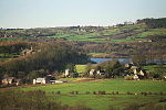 More images |
| Barn at Frith Hall Farm | Brampton | Cruck barn | Late 16th century | 31 January 1967 | SK3313070968 53°14′05″N 1°30′18″W / 53.234718°N 1.505111°W / 53.234718; -1.505111 (Barn at Frith Hall Farm) | 1218534 |  More images |
| Cutthorpe Hall | Brampton | Manor house | Mid-18th century | 31 January 1967 | SK3447573048 53°15′12″N 1°29′05″W / 53.253329°N 1.484737°W / 53.253329; -1.484737 (Cutthorpe Hall) | 1116985 |  Upload Photo |
| Aston End | Dronfield | House | 17th century | 9 January 1967 | SK3603879405 53°18′37″N 1°27′38″W / 53.310364°N 1.460592°W / 53.310364; -1.460592 (Aston End) | 1087766 | Upload Photo |
| Building to the north east of the Hall | Dronfield | Hall house | Late 17th century (with earlier remains) | 7 July 1989 | SK3512078547 53°18′10″N 1°28′28″W / 53.302714°N 1.474464°W / 53.302714; -1.474464 (Building to the north east of the Hall) | 1040018 | Upload Photo |
| Chiverton House, attached boundary walls, gatepiers and railings | Dronfield | House | 17th century | 9 January 1967 | SK3551278467 53°18′07″N 1°28′07″W / 53.301969°N 1.468591°W / 53.301969; -1.468591 (Chiverton House, attached boundary walls, gatepiers and railings) | 1087804 | Upload Photo |
| Dronfield Woodhouse Hall farmhouse and attached boundary walls | Dronfield | Farmhouse | Late 16th century | 9 January 1967 | SK3302878542 53°18′10″N 1°30′21″W / 53.302803°N 1.505855°W / 53.302803; -1.505855 (Dronfield Woodhouse Hall farmhouse and attached boundary walls) | 1187126 | Upload Photo |
| Stable court at Renishaw Hall | Renishaw Park, Eckington | Stable | 1795 | 31 January 1967 | SK4365078626 53°18′10″N 1°20′47″W / 53.302792°N 1.346464°W / 53.302792; -1.346464 (Stable court at Renishaw Hall) | 1335076 | Upload Photo |
| The Rectory | Eckington | Vicarage | Late 18th century | 31 January 1967 | SK4324979706 53°18′45″N 1°21′08″W / 53.312532°N 1.352334°W / 53.312532; -1.352334 (The Rectory) | 1370038 | Upload Photo |
| Cartledge Hall | Holmesfield | House | 1492 | 25 October 1951 | SK3233877310 53°17′30″N 1°30′59″W / 53.291772°N 1.516333°W / 53.291772; -1.516333 (Cartledge Hall) | 1109626 | Upload Photo |
| Farm outbuildings to the east of Holmesfield Hall | Holmesfield | House | 17th century | 31 January 1967 | SK3197677688 53°17′43″N 1°31′18″W / 53.295191°N 1.521726°W / 53.295191; -1.521726 (Farm outbuildings to the east of Holmesfield Hall) | 1335104 | Upload Photo |
| Holmesfield Hall | Holmesfield | House | 17th century or earlier | 31 January 1967 | SK3193777683 53°17′43″N 1°31′20″W / 53.295149°N 1.522312°W / 53.295149; -1.522312 (Holmesfield Hall) | 1109637 | Upload Photo |
| Outbuilding to the south west of Unthank Hall | Holmesfield | Farm building | Early 17th century | 31 January 1967 | SK3067876042 53°16′50″N 1°32′29″W / 53.280473°N 1.541358°W / 53.280473; -1.541358 (Outbuilding to the south west of Unthank Hall) | 1109640 | Upload Photo |
| Unthank Hall | Holmesfield | House | Earlier than late 16th century | 31 January 1967 | SK3070276072 53°16′51″N 1°32′28″W / 53.280741°N 1.540995°W / 53.280741; -1.540995 (Unthank Hall) | 1057686 |  |
| Church of St Giles | Killamarsh | Church | 12th century | 7 July 1989 | SK4612080966 53°19′25″N 1°18′33″W / 53.323615°N 1.309063°W / 53.323615; -1.309063 (Church of St Giles) | 1057656 |  More images |
| Church of Holy Cross | Morton | Church | Late 13th century | 31 January 1967 | SK4072560115 53°08′12″N 1°23′34″W / 53.136641°N 1.392709°W / 53.136641; -1.392709 (Church of Holy Cross) | 1335461 | 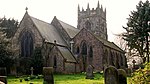 More images |
| Church of St Leonard | Shirland | Church | 15th century | 31 January 1967 | SK3997058458 53°07′18″N 1°24′15″W / 53.121804°N 1.4042°W / 53.121804; -1.4042 (Church of St Leonard) | 1158790 |  More images |
| Church of St Mary | Sutton-cum-Duckmanton | Church | Early 14th century | 31 January 1967 | SK4421268878 53°12′54″N 1°20′22″W / 53.215128°N 1.339382°W / 53.215128; -1.339382 (Church of St Mary) | 1108915 |  More images |
| Unstone Manor House | Unstone | Manor house | 1630 | 25 October 1951 | SK3694777380 53°17′32″N 1°26′50″W / 53.292101°N 1.447186°W / 53.292101; -1.447186 (Unstone Manor House) | 1335126 | Upload Photo |
| West Handley Hall | Unstone | House | Early 17th century | 31 January 1967 | SK3983677536 53°17′36″N 1°24′14″W / 53.293294°N 1.403828°W / 53.293294; -1.403828 (West Handley Hall) | 1335127 | Upload Photo |
| Stubbing Court | Wingerworth | Country house | Early–mid-18th century | 31 January 1967 | SK3570267145 53°12′01″N 1°28′01″W / 53.200189°N 1.467006°W / 53.200189; -1.467006 (Stubbing Court) | 1291898 |  More images |
See also
- Grade I listed buildings in Derbyshire
- Grade II* listed buildings in Amber Valley
- Grade II* listed buildings in Bolsover (district)
- Grade II* listed buildings in Chesterfield
- Grade II* listed buildings in Derby
- Grade II* listed buildings in Derbyshire Dales
- Grade II* listed buildings in Erewash
- Grade II* listed buildings in High Peak
- Grade II* listed buildings in South Derbyshire
Notes
- ^ The date given is the date used by Historic England as significant for the initial building or that of an important part in the structure's description.
- ^ Sometimes known as OSGB36, the grid reference is based on the British national grid reference system used by the Ordnance Survey.
- ^ The "List Entry Number" is a unique number assigned to each listed building and scheduled monument by Historic England.
External links
- v
- t
- e
- Bedfordshire
- Berkshire
- Bristol
- Buckinghamshire
- Cambridgeshire
- Cheshire
- Cornwall
- Cumbria
- Derbyshire
- Devon
- Dorset
- Durham
- East Sussex
- East Riding of Yorkshire
- Essex
- Gloucestershire
- Greater London
- Greater Manchester
- Hampshire
- Herefordshire
- Hertfordshire
- Isle of Wight
- Kent
- Lancashire
- Leicestershire
- Lincolnshire
- Merseyside
- Norfolk
- North Yorkshire
- Northamptonshire
- Northumberland
- Nottinghamshire
- Oxfordshire
- Rutland
- Shropshire
- Somerset
- South Yorkshire
- Staffordshire
- Suffolk
- Surrey
- Tyne and Wear
- Warwickshire
- West Midlands
- West Sussex
- West Yorkshire
- Wiltshire
- Worcestershire
- Allerdale
- Amber Valley
- Ashford
- Babergh
- Barrow-in-Furness
- Basildon
- Basingstoke and Deane
- Bath and North East Somerset
- Bolsover
- Boston
- Bournemouth
- Bradford
- Braintree
- Breckland
- Brentwood
- Brighton and Hove
- Bristol
- Broadland
- Calderdale
- Cambridge
- Camden
- Canterbury
- Carlisle
- Castle Point
- Chelmsford
- Cheltenham
- Cherwell
- Cheshire East
- Cheshire West and Chester
- Chesterfield
- Chiltern
- Christchurch
- Colchester
- Copeland
- Corby
- Cotswold
- Dartford
- Daventry
- Dover
- East Cambridgeshire
- Exeter
- Mendip
- North Somerset
- North Yorkshire (district)
- Poole
- Sedgemoor
- South Somerset
- Stoke-on-Trent
- Taunton Deane
- West Somerset
- York


