Grade II* listed buildings in the City of Chelmsford
Map all coordinates using OpenStreetMap
Download coordinates as:
- KML
- GPX (all coordinates)
- GPX (primary coordinates)
- GPX (secondary coordinates)
There are over 20,000 Grade II* listed buildings in England. This page is a list of these buildings in the City of Chelmsford in Essex.
List of buildings
| Name | Location | Type | Completed [note 1] | Date designated | Grid ref.[note 2] Geo-coordinates | Entry number [note 3] | Image |
|---|---|---|---|---|---|---|---|
| The Old Rectory | Boreham | House | 17th century | 10 April 1967 | TL7557109521 51°45′25″N 0°32′33″E / 51.756856°N 0.54242°E / 51.756856; 0.54242 (The Old Rectory) | 1338401 | 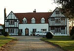 More images |
| Church of St Mary the Virgin | Broomfield | Church | Late 11th century | 10 April 1967 | TL7052410473 51°46′01″N 0°28′11″E / 51.766965°N 0.469836°E / 51.766965; 0.469836 (Church of St Mary the Virgin) | 1338425 |  More images |
| Former Church of St James | Chignal St James, Chignall | House | Late 13th and early 14th century | 10 April 1967 | TL6695209663 51°45′39″N 0°25′04″E / 51.760765°N 0.417731°E / 51.760765; 0.417731 (Former Church of St James) | 1122199 |  More images |
| Chobbing's Farmhouse | Chignal St James, Chignall | Farmhouse | Late 14th century | 19 June 1975 | TL6863709414 51°45′29″N 0°26′31″E / 51.758024°N 0.442003°E / 51.758024; 0.442003 (Chobbing's Farmhouse) | 1306286 |  More images |
| Church of St Nicholas | Chignall Smealy, Chignall | Church | Early 16th century | 10 April 1967 | TL6678711617 51°46′42″N 0°24′59″E / 51.778367°N 0.41628°E / 51.778367; 0.41628 (Church of St Nicholas) | 1170018 |  More images |
| Slough House | Danbury | House | 17th century | 29 December 1952 | TL8051803134 51°41′53″N 0°36′39″E / 51.697918°N 0.610708°E / 51.697918; 0.610708 (Slough House) | 1122172 | 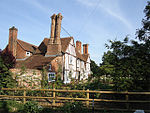 More images |
| Willis Farmhouse | East Hanningfield | Farmhouse | Early 16th century | 29 December 1952 | TL7717000799 51°40′41″N 0°33′40″E / 51.678011°N 0.561131°E / 51.678011; 0.561131 (Willis Farmhouse) | 1122177 |  Upload Photo |
| Barn at Great Seabrights Farm | Galleywood | Barn | 18th century | 29 May 1981 | TL7179703852 51°42′26″N 0°29′06″E / 51.707103°N 0.484999°E / 51.707103; 0.484999 (Barn at Great Seabrights Farm) | 1237350 |  |
| Church of St Andrew | Good Easter | Church | c.1200 | 10 April 1967 | TL6264012077 51°47′01″N 0°21′23″E / 51.783719°N 0.356438°E / 51.783719; 0.356438 (Church of St Andrew) | 1122143 |  More images |
| Church of St John the Evangelist | Little Leighs, Great and Little Leighs | Church | Early 12th century | 10 April 1967 | TL7189916750 51°49′23″N 0°29′34″E / 51.822928°N 0.49285°E / 51.822928; 0.49285 (Church of St John the Evangelist) | 1122132 |  More images |
| The Vicarage | Great Baddow | House | Early 18th century | 19 June 1975 | TL7298004755 51°42′53″N 0°30′09″E / 51.714851°N 0.502551°E / 51.714851; 0.502551 (The Vicarage) | 1170837 | Upload Photo |
| 66 and 68 High Street | Great Baddow | House | 17th century | 10 April 1967 | TL7288004850 51°42′57″N 0°30′04″E / 51.715735°N 0.501152°E / 51.715735; 0.501152 (66 and 68 High Street) | 1170982 | Upload Photo |
| Black Chapel Cottage | North End, Great Waltham | House | Late 15th century | 10 April 1967 | TL6634318187 51°50′15″N 0°24′47″E / 51.837517°N 0.413001°E / 51.837517; 0.413001 (Black Chapel Cottage) | 1171938 |  More images |
| Bollingtons | Great Waltham | House | 18th century | 29 December 1952 | TL6960213454 51°47′38″N 0°27′29″E / 51.794023°N 0.457942°E / 51.794023; 0.457942 (Bollingtons) | 1122056 |  More images |
| Fitzjohn's Farmhouse | Great Waltham | Farmhouse | 15th century | 10 April 1967 | TL6756613738 51°47′50″N 0°25′43″E / 51.797187°N 0.428585°E / 51.797187; 0.428585 (Fitzjohn's Farmhouse) | 1171901 |  More images |
| Hillhouse Farmhouse | Howe Street, Great Waltham | Farmhouse | 16th century | 29 December 1952 | TL7003915437 51°48′42″N 0°27′55″E / 51.811703°N 0.465245°E / 51.811703; 0.465245 (Hillhouse Farmhouse) | 1338490 | Upload Photo |
| Wisemans | Great Waltham | Jettied house | 16th century | 10 April 1967 | TL6942413501 51°47′40″N 0°27′19″E / 51.794499°N 0.455387°E / 51.794499; 0.455387 (Wisemans) | 1305525 | Upload Photo |
| Little Baddow Hall | Little Baddow | House | 16th century | 29 December 1952 | TL7644108022 51°44′35″N 0°33′15″E / 51.743118°N 0.554251°E / 51.743118; 0.554251 (Little Baddow Hall) | 1338483 |  More images |
| Old Riffhams | Little Baddow | House | Mid-16th century | 29 December 1952 | TL7770506565 51°43′47″N 0°34′18″E / 51.729632°N 0.571797°E / 51.729632; 0.571797 (Old Riffhams) | 1122037 |  More images |
| Brick revetting to moat and octagonal turrets at north-west and south-west angles, Killigrews | Margaretting | Moat | Early 16th century | 10 April 1967 | TL6883502787 51°41′54″N 0°26′30″E / 51.698434°N 0.441658°E / 51.698434; 0.441658 (Brick revetting to moat and octagonal turrets at north-west and south-west angles, Killigrews) | 1152176 | Upload Photo |
| Church of St Margaret | Margaretting | Church | Early–mid-15th century | 10 April 1967 | TL6651200422 51°40′40″N 0°24′25″E / 51.677882°N 0.406948°E / 51.677882; 0.406948 (Church of St Margaret) | 1338504 |  More images |
| Killigrews | Margaretting | House | 1714 | 29 December 1952 | TL6886502777 51°41′54″N 0°26′32″E / 51.698335°N 0.442087°E / 51.698335; 0.442087 (Killigrews) | 1338505 | Upload Photo |
| Church (of no known dedication) | Mashbury | Church | 12th century | 10 April 1967 | TL6515011856 51°46′52″N 0°23′34″E / 51.780999°N 0.392687°E / 51.780999; 0.392687 (Church (of no known dedication)) | 1265087 | 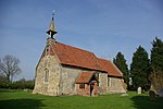 More images |
| Church of Holy Trinity | Pleshey | Church | c.1394 | 10 April 1967 | TL6632814297 51°48′09″N 0°24′39″E / 51.802578°N 0.410917°E / 51.802578; 0.410917 (Church of Holy Trinity) | 1235569 |  More images |
| Church of St Michael and All Angels | Roxwell | Church | 14th century | 10 April 1967 | TL6454608490 51°45′03″N 0°22′56″E / 51.750939°N 0.382346°E / 51.750939; 0.382346 (Church of St Michael and All Angels) | 1235784 |  More images |
| Church of St Andrew | Sandon | Church | 12th century | 10 April 1967 | TL7431104813 51°42′54″N 0°31′19″E / 51.71496°N 0.521827°E / 51.71496; 0.521827 (Church of St Andrew) | 1235849 |  More images |
| The Rectory | Sandon | House | Mid-18th century | 10 April 1967 | TL7424404668 51°42′49″N 0°31′15″E / 51.713678°N 0.520785°E / 51.713678; 0.520785 (The Rectory) | 1264863 | Upload Photo |
| Church of St Peter | South Hanningfield | Parish church | Late 11th-century or early 12th-century origin | 10 April 1967 | TQ7444698056 51°39′15″N 0°31′13″E / 51.654224°N 0.520405°E / 51.654224; 0.520405 (Church of St Peter) | 1236422 |  More images |
| Church of St Mary | Buttsbury, Stock | Church | 14th–15th century | 10 April 1967 | TQ6638498622 51°39′42″N 0°24′15″E / 51.66175°N 0.404242°E / 51.66175; 0.404242 (Church of St Mary) | 1264434 |  More images |
| Stock Windmill | Stock | Tower mill | 18th century | 10 April 1967 | TQ6981598781 51°39′44″N 0°27′14″E / 51.662153°N 0.453878°E / 51.662153; 0.453878 (Stock Windmill) | 1264461 |  More images |
| Church of St Mary and St Edward | West Hanningfield | Church | 12th century | 10 April 1967 | TQ7350899825 51°40′13″N 0°30′28″E / 51.670404°N 0.507736°E / 51.670404; 0.507736 (Church of St Mary and St Edward) | 1236738 |  More images |
| Colevile Hall | West Hanningfield | House | Late 16th century | 10 April 1967 | TL7153600246 51°40′29″N 0°28′46″E / 51.674791°N 0.479454°E / 51.674791; 0.479454 (Colevile Hall) | 1236888 | Upload Photo |
| Edwins Hall | Woodham Ferrers and Bicknacre | House | Late 16th century | 29 December 1952 | TQ8115599386 51°39′51″N 0°37′05″E / 51.664049°N 0.617972°E / 51.664049; 0.617972 (Edwins Hall) | 1236906 |  More images |
| Barn south-west of Lordship Farm | Writtle | Aisled barn | Late 15th–early 16th century | 19 June 1975 | TL6766606676 51°44′01″N 0°25′36″E / 51.733719°N 0.426628°E / 51.733719; 0.426628 (Barn south-west of Lordship Farm) | 1264255 | Upload Photo |
| Church of All Saints | Writtle | Church | Late 12th century | 10 April 1967 | TL6775006145 51°43′44″N 0°25′39″E / 51.728924°N 0.427588°E / 51.728924; 0.427588 (Church of All Saints) | 1237229 |  More images |
| Hylands House | Hylands Park, Writtle | Country house | c.1728 | 10 April 1967 | TL6848504195 51°42′40″N 0°26′14″E / 51.711187°N 0.437278°E / 51.711187; 0.437278 (Hylands House) | 1264253 | 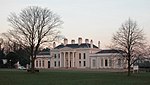 More images |
| Moor Hall | Newney Green, Writtle | House | 16th century | 29 December 1952 | TL6498306467 51°43′57″N 0°23′16″E / 51.732637°N 0.387713°E / 51.732637; 0.387713 (Moor Hall) | 1237175 | Upload Photo |
| All Saints Church, Springfield | Springfield | Church | Nave c.1100 | 20 May 1949 | TL7195107986 51°44′39″N 0°29′21″E / 51.74419°N 0.489266°E / 51.74419; 0.489266 (All Saints Church, Springfield) | 1186867 |  More images |
| Lodge Farmhouse | Chelmsford | House | c.1280–1330 | 14 December 1978 | TL6936802736 51°41′52″N 0°26′58″E / 51.697815°N 0.449338°E / 51.697815; 0.449338 (Lodge Farmhouse) | 1141329 | Upload Photo |
| Shire Hall | Chelmsford | Shire hall | 1790–91 | 20 May 1949 | TL7084406902 51°44′05″N 0°28′22″E / 51.734791°N 0.472715°E / 51.734791; 0.472715 (Shire Hall) | 1141328 | 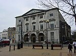 More images |
| The Old Rectory | Chelmsford | House | 1752 | 20 May 1949 | TL7180707933 51°44′38″N 0°29′14″E / 51.743758°N 0.487156°E / 51.743758; 0.487156 (The Old Rectory) | 1263936 | Upload Photo |
| The Old Rectory | Springfield | House | 1752 | 20 May 1949 | TL7181007936 51°44′38″N 0°29′14″E / 51.743784°N 0.487201°E / 51.743784; 0.487201 (The Old Rectory) | 1141369 | Upload Photo |
| 26 High Street | Chelmsford | House | Early 18th century | 20 April 1949 | TL7099306733 51°44′00″N 0°28′29″E / 51.733227°N 0.474788°E / 51.733227; 0.474788 (26 High Street) | 1328766 | Upload Photo |
See also
- Grade II* listed buildings in Essex
- Grade II* listed buildings in Basildon (district)
- Grade II* listed buildings in Braintree (district)
- Grade II* listed buildings in Brentwood (borough)
- Grade II* listed buildings in Castle Point
- Grade II* listed buildings in Colchester (borough)
- Grade II* listed buildings in Epping Forest (district)
- Grade II* listed buildings in Harlow
- Grade II* listed buildings in Maldon (district)
- Grade II* listed buildings in Rochford (district)
- Grade II* listed buildings in Southend-on-Sea
- Grade II* listed buildings in Tendring
- Grade II* listed buildings in Thurrock
- Grade II* listed buildings in Uttlesford
- Grade I listed buildings in Essex
Notes
- ^ The date given is the date used by Historic England as significant for the initial building or that of an important part in the structure's description.
- ^ Sometimes known as OSGB36, the grid reference is based on the British national grid reference system used by the Ordnance Survey.
- ^ The "List Entry Number" is a unique number assigned to each listed building and scheduled monument by Historic England.
External links
- v
- t
- e
- Bedfordshire
- Berkshire
- Bristol
- Buckinghamshire
- Cambridgeshire
- Cheshire
- Cornwall
- Cumbria
- Derbyshire
- Devon
- Dorset
- Durham
- East Sussex
- East Riding of Yorkshire
- Essex
- Gloucestershire
- Greater London
- Greater Manchester
- Hampshire
- Herefordshire
- Hertfordshire
- Isle of Wight
- Kent
- Lancashire
- Leicestershire
- Lincolnshire
- Merseyside
- Norfolk
- North Yorkshire
- Northamptonshire
- Northumberland
- Nottinghamshire
- Oxfordshire
- Rutland
- Shropshire
- Somerset
- South Yorkshire
- Staffordshire
- Suffolk
- Surrey
- Tyne and Wear
- Warwickshire
- West Midlands
- West Sussex
- West Yorkshire
- Wiltshire
- Worcestershire
- Allerdale
- Amber Valley
- Ashford
- Babergh
- Barrow-in-Furness
- Basildon
- Basingstoke and Deane
- Bath and North East Somerset
- Bolsover
- Boston
- Bournemouth
- Bradford
- Braintree
- Breckland
- Brentwood
- Brighton and Hove
- Bristol
- Broadland
- Calderdale
- Cambridge
- Camden
- Canterbury
- Carlisle
- Castle Point
- Chelmsford
- Cheltenham
- Cherwell
- Cheshire East
- Cheshire West and Chester
- Chesterfield
- Chiltern
- Christchurch
- Colchester
- Copeland
- Corby
- Cotswold
- Dartford
- Daventry
- Dover
- East Cambridgeshire
- Exeter
- Mendip
- North Somerset
- North Yorkshire (district)
- Poole
- Sedgemoor
- South Somerset
- Stoke-on-Trent
- Taunton Deane
- West Somerset
- York


