Grade II* listed buildings in Uttlesford
Map all coordinates using OpenStreetMap
Download coordinates as:
- KML
- GPX (all coordinates)
- GPX (primary coordinates)
- GPX (secondary coordinates)
There are over 20,000 Grade II* listed buildings in England. This page is a list of these buildings in the district of Uttlesford in Essex.
Uttlesford
| Name | Location | Type | Completed [note 1] | Date designated | Grid ref.[note 2] Geo-coordinates | Entry number [note 3] | Image |
|---|---|---|---|---|---|---|---|
| Church of St Mary the Virgin | Arkesden, Uttlesford | Church | Norman | 21 February 1967 | TL4822534599 51°59′24″N 0°09′26″E / 51.990069°N 0.157295°E / 51.990069; 0.157295 (Church of St Mary the Virgin) | 1170054 |  More images |
| Guildhall | Church End, Ashdon | House | By 1501 | 26 November 1951 | TL5810341465 52°02′57″N 0°18′15″E / 52.049028°N 0.304202°E / 52.049028; 0.304202 (Guildhall) | 1112492 |  More images |
| Friars Grange Farmhouse | Aythorpe Roding | House | 16th century | 7 February 1952 | TL6038414324 51°48′16″N 0°19′29″E / 51.804555°N 0.324799°E / 51.804555; 0.324799 (Friars Grange Farmhouse) | 1328492 |  More images |
| Judds Cottage | Keeres Green, Aythorpe Roding | Hall House | Early 14th century | 17 October 1983 | TL5957614275 51°48′16″N 0°18′47″E / 51.804346°N 0.313068°E / 51.804346; 0.313068 (Judds Cottage) | 1141300 |  Upload Photo |
| Parish Church of St Mary | Aythorpe Roding | Parish Church | 13th century | 23 February 1967 | TL5843415350 51°48′52″N 0°17′49″E / 51.814328°N 0.29701°E / 51.814328; 0.29701 (Parish Church of St Mary) | 1141292 |  More images |
| Aythorpe Roding Windmill | Gunners Green, Aythorpe Roding | Post Mill | Late 18th century | 23 February 1967 | TL5903415159 51°48′45″N 0°18′20″E / 51.812442°N 0.305619°E / 51.812442; 0.305619 (Aythorpe Roding Windmill) | 1328785 | 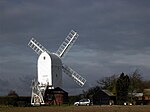 More images |
| Yeomans | Aythorpe Roding | Hall House | 14th century or 15th century | 17 October 1983 | TL6021015756 51°49′03″N 0°19′23″E / 51.81747°N 0.322939°E / 51.81747; 0.322939 (Yeomans) | 1328786 | Upload Photo |
| Barnston Hall | Barnston | House | 1920 | 7 February 1952 | TL6510819659 51°51′04″N 0°23′45″E / 51.851106°N 0.395795°E / 51.851106; 0.395795 (Barnston Hall) | 1322252 | Upload Photo |
| Barnston Lodge | Barnston | House | Late 18th century | 20 February 1967 | TL6544319666 51°51′04″N 0°24′02″E / 51.85107°N 0.400657°E / 51.85107; 0.400657 (Barnston Lodge) | 1112886 |  More images |
| Church of St Andrew | Barnston | Parish Church | c1160-1170 | 20 February 1967 | TL6523219624 51°51′03″N 0°23′51″E / 51.850755°N 0.397577°E / 51.850755; 0.397577 (Church of St Andrew) | 1308903 |  More images |
| The Old Rectory | Barnston | House | 18th century | 20 February 1967 | TL6563719473 51°50′57″N 0°24′12″E / 51.849279°N 0.403379°E / 51.849279; 0.403379 (The Old Rectory) | 1322254 | Upload Photo |
| Berden Hall | Berden | House | 16th century | 26 November 1951 | TL4674629505 51°56′41″N 0°08′01″E / 51.944694°N 0.133596°E / 51.944694; 0.133596 (Berden Hall) | 1112468 | Upload Photo |
| Berden Priory | Berden | Farmhouse | 17th century | 26 November 1951 | TL4623830224 51°57′05″N 0°07′35″E / 51.951288°N 0.126517°E / 51.951288; 0.126517 (Berden Priory) | 1112470 |  More images |
| Well House and Treadmill to North of Berden Priory | Berden | Donkey Wheel | 17th century | 21 February 1967 | TL4622130257 51°57′06″N 0°07′35″E / 51.951589°N 0.126283°E / 51.951589; 0.126283 (Well House and Treadmill to North of Berden Priory) | 1170289 | Upload Photo |
| Church of St Mary | Birchanger | Church | Early 12th century | 21 February 1967 | TL5073022781 51°53′00″N 0°11′19″E / 51.88322°N 0.188574°E / 51.88322; 0.188574 (Church of St Mary) | 1322445 |  More images |
| Barn to East of Church Hall | Church End, Broxted | Aisled Barn | Early 15th century | 20 February 1967 | TL5798127416 51°55′22″N 0°17′45″E / 51.922854°N 0.295959°E / 51.922854; 0.295959 (Barn to East of Church Hall) | 1112225 | Upload Photo |
| Church Hall | Church End, Broxted | House | Later alterations | 7 February 1952 | TL5791927397 51°55′22″N 0°17′42″E / 51.9227°N 0.295049°E / 51.9227; 0.295049 (Church Hall) | 1322561 | Upload Photo |
| Church of St Mary the Virgin | Broxted | Church | Early 13th century | 20 February 1967 | TL5784327380 51°55′21″N 0°17′38″E / 51.922569°N 0.293937°E / 51.922569; 0.293937 (Church of St Mary the Virgin) | 1112251 |  More images |
| Wood Farmhouse | Brick End, Broxted | Timber Framed House | Early 16th century or earlier | 24 October 1979 | TL5655726551 51°54′56″N 0°16′30″E / 51.915485°N 0.274876°E / 51.915485; 0.274876 (Wood Farmhouse) | 1306916 |  More images |
| Dovecote at Sibley's Farm | Chickney | Dovecote | Later | 7 February 1952 | TL5654429713 51°56′38″N 0°16′34″E / 51.943895°N 0.276124°E / 51.943895; 0.276124 (Dovecote at Sibley's Farm) | 1322581 | Upload Photo |
| Sibley's Farmhouse | Chickney | Farmhouse | 14th century | 7 February 1952 | TL5655529744 51°56′39″N 0°16′35″E / 51.94417°N 0.276298°E / 51.94417; 0.276298 (Sibley's Farmhouse) | 1322580 | Upload Photo |
| The Bury | Clavering | House | Pre-Conquest - Norman | 26 November 1951 | TL4714431935 51°57′59″N 0°08′26″E / 51.966422°N 0.140422°E / 51.966422; 0.140422 (The Bury) | 1170538 | Upload Photo |
| The Old Hall | Clavering | House | Later | 26 November 1951 | TL4702531724 51°57′52″N 0°08′19″E / 51.964557°N 0.138601°E / 51.964557; 0.138601 (The Old Hall) | 1112414 | Upload Photo |
| 1–5 Church Walk | Clavering | Jettied House | Late 15th century | 21 February 1967 | TL4704431764 51°57′54″N 0°08′20″E / 51.964912°N 0.138894°E / 51.964912; 0.138894 (1–5 Church Walk) | 1112457 |  More images |
| Brick House Farmhouse | Debden | Farmhouse | 15th century | 26 November 1951 | TL5444634094 51°59′02″N 0°14′51″E / 51.983839°N 0.247595°E / 51.983839; 0.247595 (Brick House Farmhouse) | 1112375 | Upload Photo |
| New Amberden Hall | Debden Green, Debden | House | c. 1670 | 26 November 1951 | TL5621830513 51°57′04″N 0°16′18″E / 51.951173°N 0.271748°E / 51.951173; 0.271748 (New Amberden Hall) | 1112407 | Upload Photo |
| Church of St Nicholas | Elmdon | Church | 15th century | 21 February 1967 | TL4619439663 52°02′10″N 0°07′48″E / 52.036104°N 0.129898°E / 52.036104; 0.129898 (Church of St Nicholas) | 1112358 |  More images |
| Pigots | Elmdon | Moat | Early 16th century | 21 February 1967 | TL4633739193 52°01′55″N 0°07′54″E / 52.031844°N 0.13178°E / 52.031844; 0.13178 (Pigots) | 1322504 | Upload Photo |
| Barn to North West of Waterside Preparatory School, on the West Side of the Yard | Hassobury, Farnham | Barn | c. 1300 | 22 February 1980 | TL4845125220 51°54′21″N 0°09′24″E / 51.905744°N 0.156537°E / 51.905744; 0.156537 (Barn to North West of Waterside Preparatory School, on the West Side of the Yard) | 1112313 | Upload Photo |
| Boote House | Felsted | Jettied House | c. 1596 | 7 February 1952 | TL6768620351 51°51′24″N 0°26′01″E / 51.856555°N 0.433524°E / 51.856555; 0.433524 (Boote House) | 1308644 |  More images |
| House Adjoining and now integral with Boote House | Felsted | House | C20 | 7 February 1952 | TL6769020340 51°51′23″N 0°26′01″E / 51.856455°N 0.433577°E / 51.856455; 0.433577 (House Adjoining and now integral with Boote House) | 1112870 | |
| Bury Farm Barn 50 Metres to North West | Felsted | Timber Framed Barn | Late 16th century | 22 May 1978 | TL6757720519 51°51′29″N 0°25′55″E / 51.858097°N 0.432024°E / 51.858097; 0.432024 (Bury Farm Barn 50 Metres to North West) | 1112865 | Upload Photo |
| Hartford End Mill | Hartford End, Felsted | House | Late 18th century | 6 August 1984 | TL6854017322 51°49′45″N 0°26′40″E / 51.829089°N 0.444438°E / 51.829089; 0.444438 (Hartford End Mill) | 1112855 |  More images |
| Ingrams Close | Felsted | House | c. 1800 | 20 February 1967 | TL6777520417 51°51′26″N 0°26′05″E / 51.857121°N 0.434847°E / 51.857121; 0.434847 (Ingrams Close) | 1146667 | Upload Photo |
| Leez Priory Fisherman's Hut | Felsted | House | Mid 16th century | 20 February 1967 | TL7004018593 51°50′24″N 0°28′01″E / 51.840052°N 0.466808°E / 51.840052; 0.466808 (Leez Priory Fisherman's Hut) | 1112816 | Upload Photo |
| Old Schoolmasters House adjacent to Old School to the East | Felsted | Jettied House | Early 16th century | 7 February 1952 | TL6768320367 51°51′24″N 0°26′01″E / 51.856699°N 0.433488°E / 51.856699; 0.433488 (Old Schoolmasters House adjacent to Old School to the East) | 1322255 |  More images |
| The Pavilion | Felsted | House | Mid 16th century | 6 August 1984 | TL6795820478 51°51′27″N 0°26′15″E / 51.857614°N 0.437531°E / 51.857614; 0.437531 (The Pavilion) | 1112891 | Upload Photo |
| Old Vicarage | Great Chesterford | House | 19th century | 21 February 1967 | TL5064142779 52°03′46″N 0°11′46″E / 52.062909°N 0.196051°E / 52.062909; 0.196051 (Old Vicarage) | 1112297 |  More images |
| Brands Farmhouse | Great Dunmow | Farmhouse | 14th century | 7 February 1952 | TL6085719396 51°51′00″N 0°20′02″E / 51.849984°N 0.334008°E / 51.849984; 0.334008 (Brands Farmhouse) | 1098283 | Upload Photo |
| Brook House | Great Dunmow | Kitchen | 16th century | 20 February 1967 | TL6272222412 51°52′36″N 0°21′45″E / 51.876537°N 0.36248°E / 51.876537; 0.36248 (Brook House) | 1076533 | Upload Photo |
| Diabold | Great Dunmow | House | Earlier | 20 February 1967 | TL6274521945 51°52′20″N 0°21′45″E / 51.872336°N 0.362594°E / 51.872336; 0.362594 (Diabold) | 1328241 | Upload Photo |
| Maltings at Boyes Croft | Great Dunmow | Maltings | Early 16th century | 2 June 1971 | TL6283922034 51°52′23″N 0°21′50″E / 51.873108°N 0.364°E / 51.873108; 0.364 (Maltings at Boyes Croft) | 1298840 | Upload Photo |
| Porters Yard | Church End, Great Dunmow | Hall House | 14th century | 20 February 1967 | TL6288522774 51°52′47″N 0°21′54″E / 51.879742°N 0.365017°E / 51.879742; 0.365017 (Porters Yard) | 1121539 | Upload Photo |
| The Chestnuts | Great Dunmow | House | 18th century | 20 February 1967 | TL6269122014 51°52′23″N 0°21′43″E / 51.872971°N 0.361843°E / 51.872971; 0.361843 (The Chestnuts) | 1051609 | Upload Photo |
| White Horse Public House | Great Dunmow | Jettied House | Early 14th century | 24 March 1981 | TL6277221964 51°52′21″N 0°21′47″E / 51.872498°N 0.362995°E / 51.872498; 0.362995 (White Horse Public House) | 1122660 | Upload Photo |
| 20, 22 and 24 High Street | Great Dunmow | Hall House | Late 14th century | 16 February 1984 | TL6277721888 51°52′19″N 0°21′47″E / 51.871814°N 0.363032°E / 51.871814; 0.363032 (20, 22 and 24 High Street) | 1359637 | Upload Photo |
| War Memorial | Great Dunmow | Cross | 1921 | 14 October 2016 | TL6282521809 51°52′16″N 0°21′49″E / 51.871091°N 0.363691°E / 51.871091; 0.363691 (War Memorial) | 1438524 |  More images |
| Bridgefoot | Great Easton | House | 16th century | 7 February 1952 | TL6038625328 51°54′12″N 0°19′48″E / 51.903409°N 0.32993°E / 51.903409; 0.32993 (Bridgefoot) | 1322576 | Upload Photo |
| Church of St John and St Giles | Great Easton | Church | Early 12th century | 20 February 1967 | TL6076025471 51°54′17″N 0°20′08″E / 51.904586°N 0.335428°E / 51.904586; 0.335428 (Church of St John and St Giles) | 1112198 |  More images |
| Elizabeth's Cottage | Great Easton | House | Later | 28 June 1983 | TL6037626893 51°55′03″N 0°19′50″E / 51.917471°N 0.330513°E / 51.917471; 0.330513 (Elizabeth's Cottage) | 1164926 | Upload Photo |
| Thatched Cottage | Little Cambridge, Great Easton | Hall House | 14th century | 28 June 1968 | TL6197827088 51°55′08″N 0°21′14″E / 51.91876°N 0.353877°E / 51.91876; 0.353877 (Thatched Cottage) | 1317501 | Upload Photo |
| Church of St Giles | Great Hallingbury | Church | Late 11th century | 20 February 1967 | TL5113719600 51°51′16″N 0°11′35″E / 51.854531°N 0.193092°E / 51.854531; 0.193092 (Church of St Giles) | 1147293 | 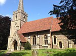 More images |
| Barrington Hall | Hatfield Broad Oak | Country House | c. 1734 | 21 July 1975 | TL5497217645 51°50′09″N 0°14′52″E / 51.835916°N 0.247855°E / 51.835916; 0.247855 (Barrington Hall) | 1097470 |  More images |
| Forest Cottage | Wood Row, Hatfield Broad Oak | House | Extension | 8 August 1985 | TL5390418797 51°50′48″N 0°13′58″E / 51.846561°N 0.232879°E / 51.846561; 0.232879 (Forest Cottage) | 1186299 | Upload Photo |
| Oak Cottage | Broad St, Hatfield Broad Oak | House | C20 | 1 April 1982 | TL5497216439 51°49′30″N 0°14′50″E / 51.825082°N 0.247315°E / 51.825082; 0.247315 (Oak Cottage) | 1097482 |  More images |
| Old Court House | Hatfield Broad Oak | House | 1985 | 8 August 1985 | TL5456016567 51°49′35″N 0°14′29″E / 51.826346°N 0.241399°E / 51.826346; 0.241399 (Old Court House) | 1299266 |  More images |
| Ploughden | Bush End, Hatfield Broad Oak | House | 1985 | 8 August 1985 | TL5508519912 51°51′23″N 0°15′02″E / 51.856252°N 0.25051°E / 51.856252; 0.25051 (Ploughden) | 1186260 |  More images |
| Rundle House | Hatfield Broad Oak | House | Early 19th century | 20 February 1967 | TL5455116512 51°49′33″N 0°14′28″E / 51.825854°N 0.241244°E / 51.825854; 0.241244 (Rundle House) | 1120880 |  More images |
| Shell House | Hatfield Forest, Hatfield Broad Oak | Garden House | c. 1757 | 8 August 1985 | TL5402519810 51°51′20″N 0°14′06″E / 51.8556°N 0.235085°E / 51.8556; 0.235085 (Shell House) | 1186279 |  More images |
| Town Farmhouse including Wall enclosing Yard | Hatfield Broad Oak | Kitchen | Late 14th century or early 15th century | 7 February 1952 | TL5456716441 51°49′31″N 0°14′29″E / 51.825212°N 0.241444°E / 51.825212; 0.241444 (Town Farmhouse including Wall enclosing Yard) | 1120907 |  More images |
| Ware Pond Cottages | Hatfield Broad Oak | Farmhouse | Early 15th century | 8 August 1985 | TL5505516511 51°49′33″N 0°14′55″E / 51.825706°N 0.248551°E / 51.825706; 0.248551 (Ware Pond Cottages) | 1334068 |  More images |
| Down Hall | Hatfield Heath | Country House | 1871-3 | 14 December 1983 | TL5225513108 51°47′45″N 0°12′23″E / 51.795901°N 0.20646°E / 51.795901; 0.20646 (Down Hall) | 1186292 |  More images |
| Lea Hall | Hatfield Heath | House | Early 17th century | 7 February 1952 | TL5286215357 51°48′57″N 0°12′58″E / 51.815941°N 0.216246°E / 51.815941; 0.216246 (Lea Hall) | 1334062 | Upload Photo |
| Church of St Andrew | Hempstead | Church | Mid 14th century by 1365 | 21 February 1967 | TL6350437996 52°00′59″N 0°22′52″E / 52.0163°N 0.381235°E / 52.0163; 0.381235 (Church of St Andrew) | 1278485 |  More images |
| Cock and Bell | High Easter | House | Later Alteration | 7 February 1952 | TL6206214773 51°48′29″N 0°20′58″E / 51.808106°N 0.349325°E / 51.808106; 0.349325 (Cock and Bell) | 1112509 |  More images |
| High Easterbury | High Easter | House | 14th century | 20 September 1985 | TL6196014668 51°48′26″N 0°20′52″E / 51.807192°N 0.347798°E / 51.807192; 0.347798 (High Easterbury) | 1147300 | Upload Photo |
| Pentlow End | High Easter | Farmhouse | Late 16th century | 20 November 1975 | TL6212816234 51°49′16″N 0°21′03″E / 51.821211°N 0.350964°E / 51.821211; 0.350964 (Pentlow End) | 1112504 | Upload Photo |
| Barn approximately 60 Metres South West of Moat at New Hall Farm | High Roothing | Barn | 17th century | 7 February 1952 | TL5795516158 51°49′18″N 0°17′26″E / 51.821723°N 0.290435°E / 51.821723; 0.290435 (Barn approximately 60 Metres South West of Moat at New Hall Farm) | 1328813 | Upload Photo |
| Parish Church of All Saints | High Roothing | Parish Church | 13th century | 20 February 1967 | TL5918616523 51°49′29″N 0°18′30″E / 51.824653°N 0.308448°E / 51.824653; 0.308448 (Parish Church of All Saints) | 1141272 |  More images |
| Church of St John the Evangelist | Upper Green, Langley | Church | 12th century | 21 February 1967 | TL4425935258 51°59′49″N 0°05′59″E / 51.997033°N 0.099855°E / 51.997033; 0.099855 (Church of St John the Evangelist) | 1278241 |  More images |
| Parish Church of St Michael and All Angels | Leaden Roding | Parish Church | 11th century | 20 February 1967 | TL5899813248 51°47′43″N 0°18′15″E / 51.795284°N 0.304221°E / 51.795284; 0.304221 (Parish Church of St Michael and All Angels) | 1328803 |  More images |
| Church of St Mary the Virgin | Lindsell | Parish Church | 12th century | 20 February 1967 | TL6436727122 51°55′06″N 0°23′19″E / 51.918366°N 0.388599°E / 51.918366; 0.388599 (Church of St Mary the Virgin) | 1112140 |  More images |
| Barn at Little Canfield Hall (50 Metres South West) | Little Canfield | Timber Framed Barn | Late 14th century | 16 February 1984 | TL5850421887 51°52′23″N 0°18′04″E / 51.873035°N 0.301018°E / 51.873035; 0.301018 (Barn at Little Canfield Hall (50 Metres South West)) | 1054762 | Upload Photo |
| Stone Hall | Little Canfield | House | 16th century | 16 February 1984 | TL5925222274 51°52′35″N 0°18′43″E / 51.876299°N 0.312052°E / 51.876299; 0.312052 (Stone Hall) | 1334091 | Upload Photo |
| Church of St Mary the Virgin | Little Chesterford | Church | Early 13th century | 21 February 1967 | TL5151441717 52°03′11″N 0°12′30″E / 52.05313°N 0.208305°E / 52.05313; 0.208305 (Church of St Mary the Virgin) | 1277390 |  More images |
| Brick House | Little Dunmow | House | Late C16-early 17th century | 7 May 1952 | TL6552720624 51°51′35″N 0°24′08″E / 51.859651°N 0.402334°E / 51.859651; 0.402334 (Brick House) | 1168301 | Upload Photo |
| Grange Farm Granary 60 Metres South of Farmhouse | Little Dunmow | Granary | 15th century or earlier | 20 February 1967 | TL6533821231 51°51′55″N 0°24′00″E / 51.86516°N 0.399883°E / 51.86516; 0.399883 (Grange Farm Granary 60 Metres South of Farmhouse) | 1251436 | Upload Photo |
| Easton Glebe | Little Easton | House | Mid 18th century | 20 February 1967 | TL6010323866 51°53′25″N 0°19′31″E / 51.890357°N 0.325142°E / 51.890357; 0.325142 (Easton Glebe) | 1334055 | Upload Photo |
| Church of St Mary the Virgin | Little Hallingbury | Church | 12th century | 20 February 1967 | TL5032617472 51°50′08″N 0°10′49″E / 51.835631°N 0.180402°E / 51.835631; 0.180402 (Church of St Mary the Virgin) | 1112021 |  More images |
| Gaston House | Gaston Green, Little Hallingbury | House | Late 18th century | 20 February 1967 | TL4987217215 51°50′00″N 0°10′25″E / 51.833444°N 0.173706°E / 51.833444; 0.173706 (Gaston House) | 1322661 |  More images |
| Hallingbury Mill | Little Hallingbury | Flour Mill | 1874 | 13 June 1983 | TL4957616922 51°49′51″N 0°10′09″E / 51.830891°N 0.169287°E / 51.830891; 0.169287 (Hallingbury Mill) | 1111991 |  More images |
| Tewes | Little Sampford | House | 16th century | 26 November 1951 | TL6405733925 51°58′46″N 0°23′14″E / 51.979568°N 0.387339°E / 51.979568; 0.387339 (Tewes) | 1231857 | Upload Photo |
| Ring Temple | Audley End Park, Littlebury | Garden Building | 1763 | 21 February 1967 | TL5155938323 52°01′21″N 0°12′27″E / 52.022626°N 0.207458°E / 52.022626; 0.207458 (Ring Temple) | 1231275 | Upload Photo |
| Church of St Mary the Virgin | Manuden | Church | 12th century | 21 February 1967 | TL4910426665 51°55′07″N 0°10′00″E / 51.918552°N 0.166647°E / 51.918552; 0.166647 (Church of St Mary the Virgin) | 1233999 |  More images |
| Clock House, North House, South House | Shortgrove, Newport | House | 1980 | 21 February 1967 | TL5267035326 51°59′43″N 0°13′20″E / 51.995397°N 0.222302°E / 51.995397; 0.222302 (Clock House, North House, South House) | 1235092 | Upload Photo |
| Crown House | Newport | House | Late 17th century | 26 November 1951 | TL5216834557 51°59′19″N 0°12′53″E / 51.988626°N 0.214655°E / 51.988626; 0.214655 (Crown House) | 1234043 |  More images |
| Monk's Barn | Newport | House | Later | 26 November 1951 | TL5215933938 51°58′59″N 0°12′51″E / 51.983068°N 0.21425°E / 51.983068; 0.21425 (Monk's Barn) | 1234841 |  More images |
| Newport House | Newport | House | 18th century | 21 February 1967 | TL5212933940 51°58′59″N 0°12′50″E / 51.983094°N 0.213814°E / 51.983094; 0.213814 (Newport House) | 1275835 | Upload Photo |
| Old Vicarage | Newport | Jettied House | Early 16th century | 21 February 1967 | TL5213833835 51°58′56″N 0°12′50″E / 51.982148°N 0.213899°E / 51.982148; 0.213899 (Old Vicarage) | 1234747 |  More images |
| The Georgians | Newport | House | 18th century | 21 February 1967 | TL5213233801 51°58′55″N 0°12′50″E / 51.981844°N 0.213796°E / 51.981844; 0.213796 (The Georgians) | 1275909 | Upload Photo |
| Tudor House | Newport | Farmhouse | 15th century | 26 November 1951 | TL5214834622 51°59′21″N 0°12′52″E / 51.989216°N 0.214393°E / 51.989216; 0.214393 (Tudor House) | 1276293 |  More images |
| Church of St Simon and St Jude | Quendon, Quendon and Rickling | Church | 13th century | 21 February 1967 | TL5154830664 51°57′14″N 0°12′14″E / 51.953821°N 0.203916°E / 51.953821; 0.203916 (Church of St Simon and St Jude) | 1216675 |  More images |
| Dovecote to West of Quendon Hall | Quendon Park, Quendon and Rickling | Dovecote | 17th century | 26 November 1951 | TL5145331861 51°57′53″N 0°12′11″E / 51.964601°N 0.203062°E / 51.964601; 0.203062 (Dovecote to West of Quendon Hall) | 1217182 | Upload Photo |
| Forecourt Walls and Gate Piers to South of Quendon Hall | Quendon Park, Quendon and Rickling | Gate Pier | 17th century | 21 February 1967 | TL5154031768 51°57′49″N 0°12′15″E / 51.963741°N 0.204286°E / 51.963741; 0.204286 (Forecourt Walls and Gate Piers to South of Quendon Hall) | 1216683 | Upload Photo |
| Quendon Court | Quendon, Quendon and Rickling | House | Medieval | 21 February 1967 | TL5139330238 51°57′00″N 0°12′05″E / 51.950036°N 0.201475°E / 51.950036; 0.201475 (Quendon Court) | 1275800 |  More images |
| Rickling Hall | Rickling, Quendon and Rickling | Hall | C14-C15 | 26 November 1951 | TL5003730302 51°57′04″N 0°10′54″E / 51.950978°N 0.181787°E / 51.950978; 0.181787 (Rickling Hall) | 1216666 |  More images |
| Church of St Mary the Virgin | The Village, Radwinter | Church | 14th century | 21 February 1967 | TL6063137275 52°00′38″N 0°20′21″E / 52.010662°N 0.339069°E / 52.010662; 0.339069 (Church of St Mary the Virgin) | 1221254 |  More images |
| The Old Vicarage | Radwinter | House | Modern | 26 November 1951 | TL6060837237 52°00′37″N 0°20′19″E / 52.010327°N 0.338716°E / 52.010327; 0.338716 (The Old Vicarage) | 1221273 |  More images |
| Ashcroft Court | Saffron Walden | House | c. 1800 | 28 November 1951 | TL5377838562 52°01′27″N 0°14′24″E / 52.024164°N 0.239879°E / 52.024164; 0.239879 (Ashcroft Court) | 1196153 | Upload Photo |
| Barclays Bank | Saffron Walden | Steps | 1874 | 1 November 1972 | TL5389738544 52°01′26″N 0°14′30″E / 52.023969°N 0.241604°E / 52.023969; 0.241604 (Barclays Bank) | 1297732 |  More images |
| Bridge House the Corner House | Saffron Walden | House | Early 16th century | 28 November 1951 | TL5354538653 52°01′30″N 0°14′11″E / 52.025046°N 0.236527°E / 52.025046; 0.236527 (Bridge House the Corner House) | 1204544 | Upload Photo |
| Burntwood End | Little Walden, Saffron Walden | House | 19th century | 1 November 1972 | TL5414242878 52°03′46″N 0°14′50″E / 52.062836°N 0.247124°E / 52.062836; 0.247124 (Burntwood End) | 1196099 | Upload Photo |
| Commemorative Column north east of Audley End House | Audley End, Saffron Walden | Column | 1774 | 28 November 1951 | TL5267138944 52°01′40″N 0°13′26″E / 52.027901°N 0.223928°E / 52.027901; 0.223928 (Commemorative Column north east of Audley End House) | 1196117 | Upload Photo |
| Lion Gate | Audley End, Saffron Walden | Gate | 1616 | 1 November 1972 | TL5233238023 52°01′11″N 0°13′07″E / 52.01972°N 0.218581°E / 52.01972; 0.218581 (Lion Gate) | 1204373 |  More images |
| Temple east of Audley End House | Audley End, Saffron Walden | Temple | 1790 | 1 November 1972 | TL5280038100 52°01′13″N 0°13′32″E / 52.020283°N 0.22543°E / 52.020283; 0.22543 (Temple east of Audley End House) | 1196116 |  More images |
| South Boundary Wall to Park | Audley End, Saffron Walden | Gate | Early 17th century | 28 November 1951 | TL5299237926 52°01′07″N 0°13′41″E / 52.018667°N 0.228148°E / 52.018667; 0.228148 (South Boundary Wall to Park) | 1204384 | Upload Photo |
| 1–7 Village Street | Audley End, Saffron Walden | House | Later alterations | 28 November 1951 | TL5248537947 52°01′08″N 0°13′15″E / 52.018995°N 0.220775°E / 52.018995; 0.220775 (1–7 Village Street) | 1196244 | Upload Photo |
| 2–28, Village Street | Audley End, Saffron Walden | House | 17th century | 28 November 1951 | TL5246937942 52°01′08″N 0°13′14″E / 52.018955°N 0.22054°E / 52.018955; 0.22054 (2–28, Village Street) | 1196245 |  More images |
| Cromwell House | 23, Church St, Saffron Walden | House | 16th century | 28 November 1951 | TL5378838566 52°01′27″N 0°14′24″E / 52.024197°N 0.240026°E / 52.024197; 0.240026 (Cromwell House) | 1196154 |  More images |
| Cross Keys Hotel | Saffron Walden | House | 16th century | 28 November 1951 | TL5373338455 52°01′24″N 0°14′21″E / 52.023215°N 0.239176°E / 52.023215; 0.239176 (Cross Keys Hotel) | 1196188 |  More images |
| Eight Bells Inn | Saffron Walden | Inn | Early 15th century | 28 November 1951 | TL5355538680 52°01′31″N 0°14′12″E / 52.025285°N 0.236684°E / 52.025285; 0.236684 (Eight Bells Inn) | 1196128 |  More images |
| Jubilee House | Saffron Walden | House | c. 1720 | 28 November 1951 | TL5387838426 52°01′22″N 0°14′29″E / 52.022914°N 0.241274°E / 52.022914; 0.241274 (Jubilee House) | 1196204 | Upload Photo |
| Sparrows Charity | Saffron Walden | House | Late 16th century | 28 November 1951 | TL5373638535 52°01′26″N 0°14′21″E / 52.023933°N 0.239255°E / 52.023933; 0.239255 (Sparrows Charity) | 1205520 | Upload Photo |
| The Priory | Saffron Walden | House | c. 1600 | 28 November 1951 | TL5396438562 52°01′27″N 0°14′33″E / 52.024112°N 0.242588°E / 52.024112; 0.242588 (The Priory) | 1297783 |  More images |
| No 21, High Street | Saffron Walden | Apartment | 17th century | 29 August 1969 | TL5367738497 52°01′25″N 0°14′18″E / 52.023606°N 0.238379°E / 52.023606; 0.238379 (No 21, High Street) | 1196187 |  |
| No 53, High St and attached Walls | Saffron Walden | House | Medieval | 28 November 1951 | TL5371938363 52°01′21″N 0°14′20″E / 52.022392°N 0.23893°E / 52.022392; 0.23893 (No 53, High St and attached Walls) | 1206038 |  More images |
| 5 and 7, Bridge Street | Saffron Walden | House | Late 17th century | 28 November 1951 | TL5356438630 52°01′29″N 0°14′12″E / 52.024834°N 0.236793°E / 52.024834; 0.236793 (5 and 7, Bridge Street) | 1204528 |  |
| 24 and 26, Bridge Street | Saffron Walden | House | Mid 16th century | 28 November 1951 | TL5351338719 52°01′32″N 0°14′10″E / 52.025647°N 0.23609°E / 52.025647; 0.23609 (24 and 26, Bridge Street) | 1204567 |  |
| 27 and 29, Bridge Street | Saffron Walden | House | 16th century | 28 November 1951 | TL5352038679 52°01′31″N 0°14′10″E / 52.025286°N 0.236174°E / 52.025286; 0.236174 (27 and 29, Bridge Street) | 1297807 | Upload Photo |
| 31, Bridge Street | Saffron Walden | House | Late 16th century | 28 November 1951 | TL5351938688 52°01′31″N 0°14′10″E / 52.025367°N 0.236164°E / 52.025367; 0.236164 (31, Bridge Street) | 1196126 | Upload Photo |
| 33, Bridge Street | Saffron Walden | House | 17th century | 28 November 1951 | TL5351438683 52°01′31″N 0°14′10″E / 52.025324°N 0.236089°E / 52.025324; 0.236089 (33, Bridge Street) | 1297768 | Upload Photo |
| 41 and 43 Castle Street | Saffron Walden | House | 19th century | 28 November 1951 | TL5369738692 52°01′31″N 0°14′20″E / 52.025354°N 0.238758°E / 52.025354; 0.238758 (41 and 43 Castle Street) | 1280720 |  |
| 45 and 47, Castle Street | Saffron Walden | House | Later alterations | 28 November 1951 | TL5370438693 52°01′31″N 0°14′20″E / 52.025361°N 0.23886°E / 52.025361; 0.23886 (45 and 47, Castle Street) | 1205408 | |
| 49 and 51, Castle Street | Saffron Walden | House | 15th and 17th-century | 28 November 1951 | TL5371138698 52°01′31″N 0°14′20″E / 52.025404°N 0.238964°E / 52.025404; 0.238964 (49 and 51, Castle Street) | 1205418 |  |
| 1, Freshwell Street | Saffron Walden | House | 19th century | 28 November 1951 | TL5355538642 52°01′30″N 0°14′12″E / 52.024944°N 0.236667°E / 52.024944; 0.236667 (1, Freshwell Street) | 1297749 | Upload Photo |
| 11, 13 and 15, Museum Street | Saffron Walden | House | 19th century | 28 November 1951 | TL5377838683 52°01′31″N 0°14′24″E / 52.025251°N 0.239933°E / 52.025251; 0.239933 (11, 13 and 15, Museum Street) | 1298578 |  |
| 17, 19 and 21, King Street | Saffron Walden | House | Early 16th century | 28 November 1951 | TL5379238457 52°01′24″N 0°14′24″E / 52.023216°N 0.240036°E / 52.023216; 0.240036 (17, 19 and 21, King Street) | 1206346 |  More images |
| 13a and 15, King Street | Saffron Walden | House | c. 1800 | 28 November 1951 | TL5382038473 52°01′24″N 0°14′26″E / 52.023352°N 0.240451°E / 52.023352; 0.240451 (13a and 15, King Street) | 1196208 |  |
| 4, Market Hill | Saffron Walden | House | c. 1800 | 28 November 1951 | TL5384938559 52°01′27″N 0°14′27″E / 52.024117°N 0.240912°E / 52.024117; 0.240912 (4, Market Hill) | 1206460 |  |
| 12 and 14, Market Hill | Saffron Walden | House | Mid 16th century | 28 November 1951 | TL5383038589 52°01′28″N 0°14′26″E / 52.024392°N 0.240648°E / 52.024392; 0.240648 (12 and 14, Market Hill) | 1196216 |  More images |
| Church of St Mary the Virgin | Stansted Mountfitchet | Church | 1120-1124 | 21 February 1967 | TL5210724174 51°53′43″N 0°12′33″E / 51.895361°N 0.209179°E / 51.895361; 0.209179 (Church of St Mary the Virgin) | 1238498 |  More images |
| Stansted Mountfitchet Windmill | Stansted Mountfitchet | Tower Mill | 1787 | 26 November 1951 | TL5097624740 51°54′03″N 0°11′35″E / 51.900754°N 0.193003°E / 51.900754; 0.193003 (Stansted Mountfitchet Windmill) | 1221435 |  More images |
| Parsonage Farmhouse | Stebbing | Kitchen | Late 15th century | 7 February 1952 | TL6626023888 51°53′20″N 0°24′52″E / 51.888754°N 0.414539°E / 51.888754; 0.414539 (Parsonage Farmhouse) | 1322281 |  More images |
| Porters Hall | Stebbing | House | Earlier | 7 February 1952 | TL6775723668 51°53′11″N 0°26′10″E / 51.886329°N 0.436164°E / 51.886329; 0.436164 (Porters Hall) | 1322338 |  More images |
| Stebbing Memorial Club | Stebbing | Public Library | c. 1674 | 20 February 1967 | TL6620924152 51°53′28″N 0°24′50″E / 51.89114°N 0.413926°E / 51.89114; 0.413926 (Stebbing Memorial Club) | 1168695 | Upload Photo |
| Stebbing Mill | Stebbing | Feed Mill | 18th century | 20 February 1967 | TL6586024063 51°53′26″N 0°24′32″E / 51.890445°N 0.408816°E / 51.890445; 0.408816 (Stebbing Mill) | 1322337 | Upload Photo |
| Stebbing Park | Stebbing Park, Stebbing | House | Later | 7 May 1952 | TL6574224433 51°53′38″N 0°24′26″E / 51.893803°N 0.407281°E / 51.893803; 0.407281 (Stebbing Park) | 1306764 | Upload Photo |
| Tan Farmhouse | Stebbing | Farmhouse | 15th century | 7 February 1952 | TL6599124122 51°53′27″N 0°24′39″E / 51.890936°N 0.410746°E / 51.890936; 0.410746 (Tan Farmhouse) | 1112728 | Upload Photo |
| Chestnuts | Takeley | House | 19th century | 10 September 1981 | TL5574421309 51°52′07″N 0°15′39″E / 51.868619°N 0.2607°E / 51.868619; 0.2607 (Chestnuts) | 1322589 |  More images |
| Josephes | Takeley | House | Modern | 10 September 1981 | TL5453421290 51°52′08″N 0°14′35″E / 51.868784°N 0.243131°E / 51.868784; 0.243131 (Josephes) | 1169005 |  More images |
| Moat Cottage | Smith's Green, Takeley | Timber Framed House | Mid 16th century | 20 February 1967 | TL5658521308 51°52′06″N 0°16′22″E / 51.868375°N 0.272904°E / 51.868375; 0.272904 (Moat Cottage) | 1112211 | Upload Photo |
| Sheering Hall | Bambers Green, Takeley | House | 18th century | 10 September 1981 | TL5756422889 51°52′56″N 0°17′16″E / 51.882303°N 0.287832°E / 51.882303; 0.287832 (Sheering Hall) | 1306827 | Upload Photo |
| Borough Farmhouse | Thaxted | Farmhouse | Late 14th century | 20 February 1967 | TL6070430785 51°57′08″N 0°20′14″E / 51.95234°N 0.337094°E / 51.95234; 0.337094 (Borough Farmhouse) | 1112972 |  More images |
| Goddards Farmhouse | Boyton End, Thaxted | Farmhouse | Late 16th century | 7 February 1952 | TL6124032435 51°58′01″N 0°20′44″E / 51.967007°N 0.345661°E / 51.967007; 0.345661 (Goddards Farmhouse) | 1165505 | Upload Photo |
| Park Farmhouse | Thaxted | House | 17th century | 7 February 1952 | TL6116630692 51°57′05″N 0°20′38″E / 51.951371°N 0.343767°E / 51.951371; 0.343767 (Park Farmhouse) | 1112927 |  More images |
| Prouds Farmhouse | Thaxted | Farmhouse | 14th century | 7 February 1952 | TL6044532663 51°58′09″N 0°20′03″E / 51.969285°N 0.334205°E / 51.969285; 0.334205 (Prouds Farmhouse) | 1112152 | Upload Photo |
| Recorder's House | 17, Town St, Thaxted | Jettied House | Mid 15th century | 7 February 1952 | TL6118130911 51°57′12″N 0°20′39″E / 51.953334°N 0.344088°E / 51.953334; 0.344088 (Recorder's House) | 1112902 |  More images |
| The Manse | 19, Town St, Thaxted | House | Early 19th century | 20 February 1967 | TL6117530914 51°57′12″N 0°20′38″E / 51.953362°N 0.344002°E / 51.953362; 0.344002 (The Manse) | 1322261 |  More images |
| The Priory | 38, Town St, Thaxted | House | 18th century | 20 February 1967 | TL6114630987 51°57′14″N 0°20′37″E / 51.954027°N 0.343615°E / 51.954027; 0.343615 (The Priory) | 1112944 | Upload Photo |
| Town House | 25, Town St, Thaxted | House | late 15th century or early 16th century | 20 February 1967 | TL6114330934 51°57′13″N 0°20′37″E / 51.953551°N 0.343546°E / 51.953551; 0.343546 (Town House) | 1112904 | Upload Photo |
| John Webb's Windmill | Thaxted | Tower Mill | 1804 | 7 February 1952 | TL6096630818 51°57′09″N 0°20′27″E / 51.95256°N 0.340919°E / 51.95256; 0.340919 (John Webb's Windmill) | 1112153 |  More images |
| 16 Watling Street | Thaxted | House | 18th century | 20 February 1967 | TL6110031049 51°57′17″N 0°20′35″E / 51.954597°N 0.342975°E / 51.954597; 0.342975 (16 Watling Street) | 1166190 |  More images |
| 1, Stoney Lane | Thaxted | House | 14th century with 18th century alterations | 20 February 1967 | TL6113330956 51°57′14″N 0°20′36″E / 51.953752°N 0.343411°E / 51.953752; 0.343411 (1, Stoney Lane) | 1112933 | Upload Photo |
| Tilty Mill | Tilty | Watermill | Early 18th century | 10 September 1981 | TL5994426734 51°54′58″N 0°19′27″E / 51.916167°N 0.324163°E / 51.916167; 0.324163 (Tilty Mill) | 1112221 |  More images |
| Church of St Peter | Ugley | Church | 13th century | 21 February 1967 | TL5196128755 51°56′12″N 0°12′33″E / 51.936557°N 0.209078°E / 51.936557; 0.209078 (Church of St Peter) | 1275055 | 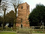 More images |
| Orford House | Ugley | House | c. 1700 | 21 February 1967 | TL5147627081 51°55′18″N 0°12′05″E / 51.92165°N 0.201293°E / 51.92165; 0.201293 (Orford House) | 1221630 |  More images |
| Dovecote at Hall Farm, Lofts Hall | Lofts Hall, Wenden Lofts | Dovecote | 16th century | 21 February 1967 | TL4644438721 52°01′39″N 0°07′59″E / 52.027575°N 0.133137°E / 52.027575; 0.133137 (Dovecote at Hall Farm, Lofts Hall) | 1238148 | Upload Photo |
| Barn to North of Colville Hall | White Roothing | Barn | 15th century Or early 16th century | 13 June 1983 | TL5535613456 51°47′53″N 0°15′06″E / 51.798176°N 0.251547°E / 51.798176; 0.251547 (Barn to North of Colville Hall) | 1308419 | Upload Photo |
| Byre to West of Colville Hall | White Roothing | Cow House | LATE 14th century or Early 15th century | 13 June 1983 | TL5533013416 51°47′52″N 0°15′04″E / 51.797824°N 0.251152°E / 51.797824; 0.251152 (Byre to West of Colville Hall) | 1112004 | Upload Photo |
| Cammas Hall | White Roothing | Hall | Late 16th century | 7 February 1952 | TL5653615302 51°48′52″N 0°16′10″E / 51.814431°N 0.269477°E / 51.814431; 0.269477 (Cammas Hall) | 1111989 | Upload Photo |
| Church of St Martin | White Roothing | Church | 11th century | 20 February 1967 | TL5617513351 51°47′49″N 0°15′48″E / 51.797005°N 0.263366°E / 51.797005; 0.263366 (Church of St Martin) | 1322680 |  More images |
| Colville Hall | White Roothing | House | Later | 7 February 1952 | TL5536713420 51°47′52″N 0°15′06″E / 51.797849°N 0.25169°E / 51.797849; 0.25169 (Colville Hall) | 1112003 | Upload Photo |
| Gateway at Colville Hall | White Roothing | Gate | Early 16th century | 7 February 1952 | TL5541313373 51°47′51″N 0°15′08″E / 51.797414°N 0.252335°E / 51.797414; 0.252335 (Gateway at Colville Hall) | 1147664 | Upload Photo |
| Granary to North West of Colville Hall | White Roothing | Granary | 15th century | 13 June 1983 | TL5536813447 51°47′53″N 0°15′06″E / 51.798092°N 0.251716°E / 51.798092; 0.251716 (Granary to North West of Colville Hall) | 1112005 | Upload Photo |
| Lower Barn North East of Colville Hall | White Roothing | Barn | 1630 | 13 June 1983 | TL5534113479 51°47′54″N 0°15′05″E / 51.798387°N 0.251339°E / 51.798387; 0.251339 (Lower Barn North East of Colville Hall) | 1322692 | Upload Photo |
| Lucas Farm House | White Roothing | Farmhouse | Early and mid 16th century | 13 June 1983 | TL5765813787 51°48′02″N 0°17′06″E / 51.800506°N 0.285052°E / 51.800506; 0.285052 (Lucas Farm House) | 1322653 |  More images |
| Brick House | Wicken Bonhunt | House | c. 1600 | 26 November 1951 | TL4973233102 51°58′34″N 0°10′43″E / 51.976216°N 0.178572°E / 51.976216; 0.178572 (Brick House) | 1238316 | Upload Photo |
| Church of St Margaret | Wicken Bonhunt | Church | 13th century | 21 February 1967 | TL4988733346 51°58′42″N 0°10′51″E / 51.978366°N 0.180934°E / 51.978366; 0.180934 (Church of St Margaret) | 1238314 |  More images |
| Church of St Mary the Virgin | Widdington | Church | 12th century | 21 February 1967 | TL5397231779 51°57′47″N 0°14′23″E / 51.963173°N 0.239661°E / 51.963173; 0.239661 (Church of St Mary the Virgin) | 1238372 |  More images |
| Thistley Hall | Widdington | House | c. 1670 | 26 November 1951 | TL5563731090 51°57′23″N 0°15′49″E / 51.95652°N 0.263562°E / 51.95652; 0.263562 (Thistley Hall) | 1112403 |  More images |
| Broadoaks Farmhouse | Wimbish | Farmhouse | 1980 | 26 November 1951 | TL5899133570 51°58′40″N 0°18′49″E / 51.97785°N 0.313478°E / 51.97785; 0.313478 (Broadoaks Farmhouse) | 1238676 |  More images |
| Operations Block, Carver Barracks (former RAF Debden) | Caversfield, Wimbish | Barracks | 1938 | 1 December 2005 | TL5686234523 51°59′13″N 0°16′59″E / 51.987016°N 0.282942°E / 51.987016; 0.282942 (Operations Block, Carver Barracks (former RAF Debden)) | 1392874 | Upload Photo |
Notes
- ^ The date given is the date used by Historic England as significant for the initial building or that of an important part in the structure's description.
- ^ Sometimes known as OSGB36, the grid reference is based on the British national grid reference system used by the Ordnance Survey.
- ^ The "List Entry Number" is a unique number assigned to each listed building and scheduled monument by Historic England.
External links
- v
- t
- e
- Bedfordshire
- Berkshire
- Bristol
- Buckinghamshire
- Cambridgeshire
- Cheshire
- Cornwall
- Cumbria
- Derbyshire
- Devon
- Dorset
- Durham
- East Sussex
- East Riding of Yorkshire
- Essex
- Gloucestershire
- Greater London
- Greater Manchester
- Hampshire
- Herefordshire
- Hertfordshire
- Isle of Wight
- Kent
- Lancashire
- Leicestershire
- Lincolnshire
- Merseyside
- Norfolk
- North Yorkshire
- Northamptonshire
- Northumberland
- Nottinghamshire
- Oxfordshire
- Rutland
- Shropshire
- Somerset
- South Yorkshire
- Staffordshire
- Suffolk
- Surrey
- Tyne and Wear
- Warwickshire
- West Midlands
- West Sussex
- West Yorkshire
- Wiltshire
- Worcestershire
- Allerdale
- Amber Valley
- Ashford
- Babergh
- Barrow-in-Furness
- Basildon
- Basingstoke and Deane
- Bath and North East Somerset
- Bolsover
- Boston
- Bournemouth
- Bradford
- Braintree
- Breckland
- Brentwood
- Brighton and Hove
- Bristol
- Broadland
- Calderdale
- Cambridge
- Camden
- Canterbury
- Carlisle
- Castle Point
- Chelmsford
- Cheltenham
- Cherwell
- Cheshire East
- Cheshire West and Chester
- Chesterfield
- Chiltern
- Christchurch
- Colchester
- Copeland
- Corby
- Cotswold
- Dartford
- Daventry
- Dover
- East Cambridgeshire
- Exeter
- Mendip
- North Somerset
- North Yorkshire (district)
- Poole
- Sedgemoor
- South Somerset
- Stoke-on-Trent
- Taunton Deane
- West Somerset
- York


