Distretto di Kenora

Questa voce sull'argomento Ontario è solo un abbozzo.
Contribuisci a migliorarla secondo le convenzioni di Wikipedia.
| Distretto di Kenora distretto | |
|---|---|
| Kenora District | |
| Localizzazione | |
| Stato |  Canada Canada |
| Provincia |  Ontario Ontario |
| Amministrazione | |
| Capoluogo | Kenora |
| Lingue ufficiali | inglese |
| Territorio | |
| Coordinate del capoluogo | 49°46′N 94°29′W49°46′N, 94°29′W (Distretto di Kenora) |
| Superficie | 407 192,66 km² |
| Abitanti | 64 419 (2006) |
| Densità | 0,16 ab./km² |
| Altre informazioni | |
| Cod. postale | P0V, P0X, P0Y, P8N, P8T, P9N |
| Prefisso | 807 |
| Fuso orario | UTC-5 |
| Cartografia | |
  Kenora | |
 | |
| Sito istituzionale | |
| Modifica dati su Wikidata · Manuale | |
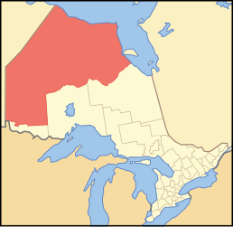
Il distretto di Kenora è un distretto dell'Ontario in Canada, nella regione dell'Ontario nordoccidentale. Al 2006 contava una popolazione di 64.419 abitanti. Il suo capoluogo è Kenora.
Suddivisioni
Città
- Dryden
- Kenora
Towns

- Red Lake
- Sioux Lookout
Townships
- Ear Falls
- Ignace
- Machin
- Pickle Lake
- Sioux Narrows-Nestor Falls
Riserva indiana
- Attawapiskat
- Bearskin Lake
- Cat Lake
- Deer Lake
- Eabametoong
- Eagle Lake 27
- English River 21
- Fort Albany 67 (part)
- Fort Severn 89
- Islington 29
- Kasabonika
- Keewaywin
- Kenora 38B
- Kingfisher Lake
- Kitchenuhmaykoosib Inninuwug
- Lac Seul
- Lake of the Woods 31G
- Lake of the Woods 37
- Marten Falls
- Mishkeegogamang
- Muskrat Dam Lake
- Neskantaga
- Northwest Angle 33
- North Spirit Lake
- Pikangikum
- Poplar Hill
- Rat Portage 38A
- Sabaskong Bay 35D
- Sachigo Lake
- Sandy Lake
- Shoal Lake 39A (part)
- Shoal Lake 40 (part)
- Shoal Lake 34B2
- The Dalles 38C
- Wabauskang 21
- Wabigoon Lake
- Wapekeka
- Wawakapewin
- Weagamow Lake 87
- Whitefish Bay 32A
- Whitefish Bay 33A
- Whitefish Bay 34A
- Wunnumin Lake
First Nations insediamenti
- Frenchman's Head
- Kejick Bay
- Lansdowne House
- MacDowell Lake
- Muskrat Dam
- Peawanuck
- Slate Falls
- Summer Beaver
- Webequie
- Whitefish Bay
Aree non organizzate
- Kenora, Unorganized (compresi i servizi locali di Greater Oxdrift, Melgund, Minaki, Redditt, Round Lake, and Wabigoon)
Altri progetti
Altri progetti
- Wikimedia Commons
 Wikimedia Commons contiene immagini o altri file su Distretto di Kenora
Collegamenti esterni
- Sito ufficiale, su kdsb.on.ca.


V · D · M | ||
|---|---|---|
| Contee | Bruce · Dufferin · Elgin · Essex · Frontenac · Grey · Haliburton · Hastings · Huron · Lambton · Lanark · Leeds e Grenville · Lennox e Addington · Middlesex · Northumberland · Perth · Peterborough · Prescott e Russell · Renfrew · Simcoe · Stormont, Dundas e Glengarry · Wellington |  |
| Distretti | Algoma · Cochrane · Kenora · Manitoulin · Nipissing · Parry Sound · Rainy River · Sudbury · Thunder Bay · Timiskaming | |
| Municipalità regionali | Durham · Halton · Muskoka · Niagara · Oxford · Peel · Waterloo · York | |
| Municipalità di livello singolo | Brant · Brantford · Chatham-Kent · Greater Sudbury · Haldimand · Hamilton · Kawartha Lakes · Norfolk · Ottawa · Prince Edward · Toronto | |
| Municipalità separate | Barrie · Belleville · Brockville · Gananoque · Guelph · Kingston · London · Orillia · Pembroke · Peterborough · Prescott · Quinte West · Smiths Falls · St. Marys · St. Thomas · Stratford · Windsor | |
| Regioni | Ontario orientale · Ontario centrale · Golden Horseshoe · Grande Toronto · Ontario sudoccidentale · Ontario settentrionale · Ontario nordorientale · Ontario nordoccidentale · Ontario meridionale | |
 Portale Canada: accedi alle voci di Wikipedia che parlano del Canada


